Blog

Sunday Streets Excelsior Celebrates the Neighborhood, Its Small Businesses and Local Resources

Sunday Streets Excelsior by Judith Sandoval

***PRESS RELEASE***

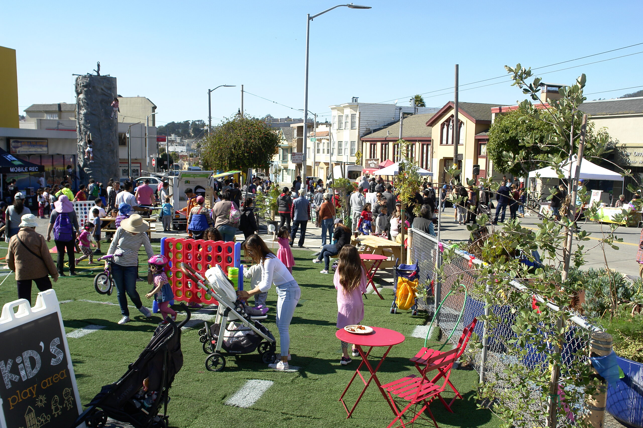
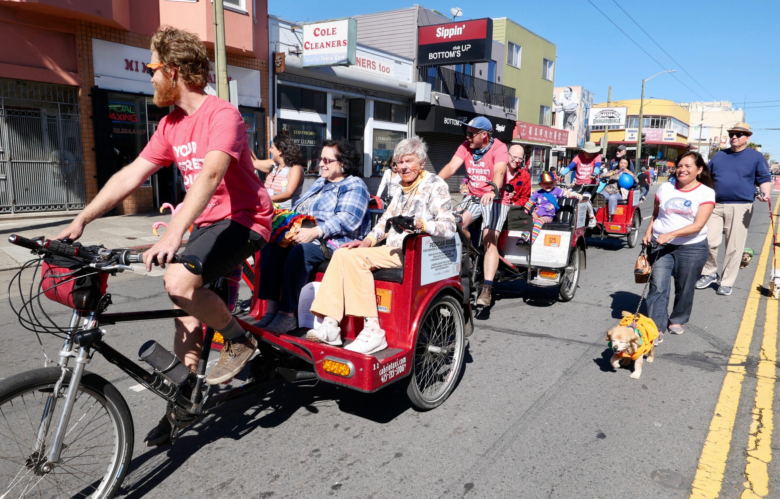
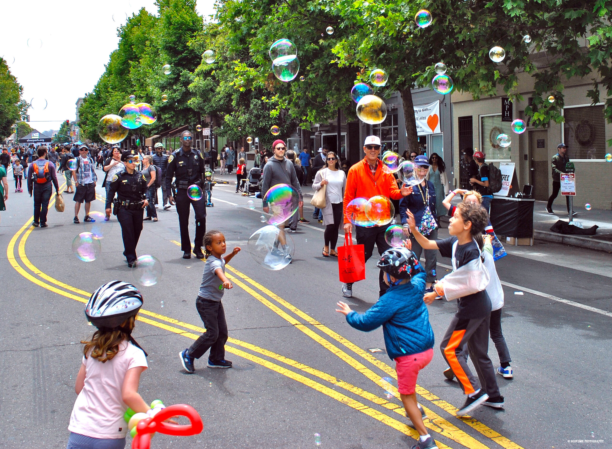
San Francisco –  Sunday Streets Excelsior returns on March 29, when Mission Street from Silver to Geneva Avenue transforms into a free, fun open space for the community from 11 a.m. to 4 p.m. With live music, resources, activities and a mile-long temporary park, the event showcases the area’s small businesses, local organizations and the diverse, family-filled neighborhood itself.

“Sunday Streets, shaped by the residents, businesses and nonprofits within the neighborhood, offers great opportunities for families, neighbors and visitors to engage with the rich culture of the Excelsior, have fun and support local merchants,” said Joaquín Torres, Director of the San Francisco Office of Economic and Workforce Development. “OEWD, in partnership with Livable City, is proud to support Sunday Streets in celebration of our beautiful and diverse neighborhoods, and we encourage everyone to come out and enjoy!”

Along the way, visit Activity Hubs at the southern and northern ends of the route. At Persia Triangle, residents of all ages can experience a pop-up community park with Friends of the Persia Triangle and partners SF Parks Alliance and SFOEWD.

The SF Department of Children, Youth and Their Families (DCYF) will host a Summer Pop-Up Resource Fair, and Community Youth Center partners with Livable City’s Neighborfest Program to invite residents to map their neighborhood resources and build community resilience. 

Learn about the 2020 Census with SF Counts, who will be on hand to sign people up, answer questions and offer free live screen-printing. Head to the Excelsior Branch of the Public Library for the Bookmobile, live music and fun activities. Located at the South Hub, the Market Square features local vendors and makers, while Mission Street’s small businesses are invited to vend in front of their stores.

Pick up the Excelsior Common Cents Passport at a Sunday Streets Info Booth to go on a small business scavenger hunt, discover nearby brick-and-mortars and get stamps to win prizes from a diverse array of local businesses, from yoga classes to coffee to screen-printed tees.

Sunday Streets’ Excelsior Explore Local Guide is a fun and colorful map of the neighborhood and all its year-round resources; including stores, public spaces and nonprofits. Grab a copy at Sunday Streets Info Booths to see all the area has to offer. All Sunday Streets volunteers receive a free, fresh lunch from a delicious local spot on the corridor- just another way the events center local merchants and keep economic activity in the district.

Each Sunday Streets is as unique as the neighborhood it serves, with small businesses, residents, nonprofits and local groups bringing activities, volunteers and performances to the car-free streets and contributing a distinctive character and energy to the day. 

Sunday Streets 2020 Season Schedule + Companion Events

March 8 – Mission 1

March 29 Excelsior 1

April 19Tenderloin 1 + Thai New Year and Southeast Asian Food Festival in Little Saigon

May 3 Bayview 

June 7 Sunset/Golden Gate Park

Date and Route TBADogpatch/Mission Bay

July 19Mission 2

August 23SoMa + Undiscovered SF Creative Night Market Pop-Up

September 13 Tenderloin 2 + Getting There Together: A Celebration of Seniors and Adults with Disabilities

September 27 Western Addition

October 28 Excelsior 2

The Sunday Streets 2020 season is made possible by the following sponsors: Bay Area Air Quality Management, Spin, Scoot, Jump, iHeartMedia, San Francisco Office of Economic and Workforce Development, and SF COUNTS and Event Sponsor SF Spine Pain Relief

About Sunday Streets Sunday Streets is a program of the nonprofit Livable City, presented in partnership with the San Francisco Municipal Transportation Agency and the San Francisco Department of Public Health and the Shape Up SF Coalition. Additional City support comes from the Department of Public Works, Recreation & Parks Department, SF Police Department, SF County Transportation Authority, San Francisco Mayor London Breed and her offices and the SF Board of Supervisors.

Livable City produces an annual season of Sunday Street events that reclaim car-congested streets for community health, transforming them into car-free spaces for all to enjoy.  Sunday Streets’ mission is to:

  • Create temporary open space and recreational opportunities in neighborhoods most lacking
  • Encourage physical activity
  • Foster community-building
  • Inspire people to think differently about their streets as public spaces

Livable City’s Recommendations for the March 3, 2020 Election

The March 3rd primary election includes several San Francisco ballot measures. Livable City urges you to vote yes, and support San Francisco Propositions A, B, C, and D.

Yes on Prop A – City College bond

Proposition A authorizes $845 million in general obligation bonds to fund capital improvements at City College of San Francisco. The bond will fund building repairs, earthquake safety retrofits, and energy-efficiency upgrades to City College buildings, and repair, replace, and improve  technology for labs and classrooms.

City College makes San Francisco more livable and equitable by providing education and job training to tens of thousands of San Franciscans each year. Proposition A will further City College’s educational mission and San Francisco’s livability by making college facilities safer and more accessible for students and faculty, increase the college’s resiliency after disaster, and reduce the college’s operating costs and environmental impact by making its facilities more energy- and resource-efficient.

Yes on Prop B – Earthquake Safety and Emergency Services Bond

Proposition B authorizes up to $628.5 million in general obligation bonds to build, repair, or improve City facilities that help San Francisco respond to earthquakes, fires, and other disasters. Eligible projects include the City’s emergency water system, which provides a reliable water supply during fires and disasters, as well as neighborhood fire and police stations, upgrades to the City’s 911 call center, and related public facilities and infrastructure to improve disaster response and public safety.

Yes on Prop C – Retirement Benefits for Housing Authority employees

Proposition C amends the City Charter to permit retiree healthcare coverage for certain former employees of the San Francisco Housing Authority who now work in City government.

San Francisco’s Housing Authority was founded in 1938 to administer New Deal federal funding for affordable housing. Over the decades the Housing Authority built and operated thousands of units of public housing and administered the federally-funded Section 8 program, which provides rental assistance to low-income households renting privately-owned apartments.

The Housing Authority was autonomous within City government, and like the former Redevelopment Agency, the authority administered an employee pension and retiree benefit system separate from the one that serves most other City employees.

Last year the City disbanded the troubled Housing Authority and transferred its programs and housing to other departments of the City. Proposition C will permit former Housing Authority employees who moved to City jobs to transfer their years of service at the Housing Authority to the City’s pension and retiree medical system. San Francisco has an unusual system of legislating City employee retirement benefits in our City Charter, so something as simple and sensible as allowing years of service in the Housing Authority to count towards a City pension requires a Charter amendment.

Livable City favors disbanding the Housing Authority and consolidating the City’s affordable housing programs in a single City housing department. Proposition C facilitates this consolidation, and provides a fair deal for City employees.

Yes on Prop D – Vacant Commercial Property Tax

Proposition D authorizes a vacant property tax on ground-floor commercial space in certain neighborhood commercial zoning districts and dedicates any future revenues from the tax to City programs that assist small businesses.

The tax will be assessed on the linear footage of street-facing ground level commercial space that owners or tenants have kept vacant, and how long that commercial space has been kept vacant. Building owners would be taxed only if a commercial space has been kept vacant for more than 182 days in a calendar year. Vacant days do not include periods where certain City use permits have been applied for, buildings with active construction projects, or when a fire or natural disaster has made a commercial space unusable.

In the first year (2021) the tax will be assessed at $250 per linear foot. In subsequent years it can increase up to $1000 per linear foot depending on how many preceding years the property was vacant.

Vacant commercial properties are detrimental to neighborhoods and adjacent businesses. They blight and deaden commercial streets and attract vandalism and litter. Proposition D adds a financial penalty for building owners who keep ground-floor commercial spaces vacant for long periods, and will encourage owners to improve and lease out spaces – or sell the vacant properties to someone who will.

Livable City has been working to reduce bureaucratic red tape and permit more local and neighborhood-serving shops and services, arts, and nonprofits in commercial spaces across the City. A vacant property tax will help fill vacant storefront spaces with neighborhood-serving uses. Reducing red tape lowers the risk and cost for small businesses and community-based organizations to locate in vacant commercial spaces, while the vacant property tax provides a financial incentive for owners to improve and lease vacant storefronts to eager tenants.

Proposition D applies only to vacant ground-floor commercial spaces in certain neighborhood commercial districts. The selected zoning districts include only a portion of the City’s commercial streets. We wish the Supervisors who put it on the ballot had included all the City’s Neighborhood Commercial zoning districts as well as the Residential-Commercial, Downtown Commercial, and Mixed Use zoning districts. Doing so will require another vote of the people. We hope Proposition D passes, and that the Supervisors will evaluate its effectiveness, and allow the voters to decide whether to expand the tax’s geographic reach.

Experience a Car-Free Valencia Street at Sunday Streets Mission on March 8

Sunday Streets Mission by J Perez

***PRESS RELEASE***

San Francisco –  The 2020 season of open streets in San Francisco kicks off with Sunday Streets Mission on March 8, when Valencia Street transforms from 26th Street to Duboce into a car-free temporary park for all from 11 a.m. to 4 p.m. Roll out to reclaim our city streets as public spaces for health and human connection at the first of eleven Sunday Streets this year.

“Sunday Streets is all about public health — from opening up the streets for pedestrians and bicyclists to connecting with neighbors and community,” said Dr. Grant Colfax, Director of Health. “The Department of Public Health supports Sunday Streets because neighbors can get blood pressure screenings, have a dance party, blow bubbles and access health resources, all on the same street. It’s uplifting, fun and good for your health.”

In addition to over a mile of open space for hula-hooping, bike-riding and community connection, two Activity Hubs at 24th and 16th Streets feature live music, interactive art projects, cultural performances and more. 

In partnership with Mission Housing, a pop-up Play Streets block party in front of Valencia Gardens brings sports games, bubbles, fun activities and more for residents and neighbors to come together.

Between 15th and 16th, the SF Department of Children, Youth and Their Families (DCYF) will host a Summer Pop-Up Resource Fair. At 24th Street, Northgate Christian Church brings free community arts activities, and Community Youth Center partners with Livable City’s Neighborfest Program to invite residents to map their neighborhood resources and build community resilience. Learn about the 2020 Census with SF Counts, who will be on hand to sign people up, answer questions and offer free live screen-printing.

Each Sunday Streets is as unique as the neighborhood it serves, with small businesses, residents, nonprofits and local groups bringing activities, volunteers and performances to the car-free streets and contributing a distinctive character and energy to the day. 

Sunday Streets 2020 Season Schedule + Companion Events

March 8 – Mission 1

March 29 Excelsior 1

April 19Tenderloin 1 + Thai New Year and Southeast Asian Food Festival in Little Saigon

Date and Route TBA Bayview 

June 7 Sunset/Golden Gate Park

Date and Route TBADogpatch/Mission Bay

July 19Mission 2

August 23SoMa + Undiscovered SF Creative Night Market Pop-Up

September 13 Tenderloin 2 + Getting There Together: A Celebration of Seniors and Adults with Disabilities

September 27 Western Addition

October 28 Excelsior 2

The Sunday Streets 2020 season is made possible by the following sponsors: The Sunday Streets 2020 season is made possible by the following sponsors: Bay Area Air Quality Management, Spin, Jump, iHeartMedia, SF Department of Public Works, Scoot, and SF COUNTS 2020 Census and Event Sponsor Mission Housing Development Corporation and San Francisco Spine Pain Relief

About Sunday Streets

Sunday Streets is a program of the nonprofit Livable City, presented in partnership with the San Francisco Municipal Transportation Agency and the San Francisco Department of Public Health and the Shape Up SF Coalition. Additional City support comes from the Department of Public Works, Recreation & Parks Department, SF Police Department, SF County Transportation Authority, San Francisco Mayor London Breed and her offices and the SF Board of Supervisors.

Livable City produces an annual season of Sunday Street events that reclaim car-congested streets for community health, transforming them into car-free spaces for all to enjoy.  Sunday Streets’ mission is to:

  • Create temporary open space and recreational opportunities in neighborhoods most lacking
  • Encourage physical activity
  • Foster community-building
  • Inspire people to think differently about their streets as public spaces

Sunday Streets Grows in 2020 to 11 Events as San Francisco Eyes Permanent Car-Free Spaces

Sunday Streets Mission by Dashiell Merrick-Kamm

***PRESS RELEASE***

San Francisco – Nonprofit Livable City is thrilled to announce a new season of Sunday Streets, with a landmark 11 open street events across San Francisco from March to October 2020. The season kicks off with Sunday Streets Mission on March 8 and debuts two new routes as the program expands to provide more free recreation and community-building by transforming city streets into public, car-free spaces.

“As the leading sponsor of Sunday Streets, the SFMTA is proud to see the program grow in 2020 to bring more open, car-free space to neighborhoods across San Francisco,” said SFMTA Director of Transportation Jeffrey Tumlin. “Besides encouraging walking, biking or using public transit, open streets let people connect with their community right outside their front doors.”

One of the country’s biggest open streets programs,  Sunday Streets serves 100,000 residents yearly. Each route is one to four miles in length, and turns car-congested streets into temporary parks for kids to play, seniors to stroll, organizations to connect and neighbors to meet.

Small businesses, residents, nonprofits and local groups bring activities, volunteers and performances to the car-free streets, with each contributing a distinctive character and energy to the day. The free events feature active play games, cultural performances, health resources, live music and more from 11am-4pm in diverse neighborhoods across the City, including the Mission, Excelsior, Tenderloin, Bayview, Outer Sunset, Western Addition and SoMa.

“Radical changes in how we move every day are on the table these days, like car-free Market Street,” said Livable City Associate Director Katy Birnbaum. “Sunday Streets’ goal has always been making car-free streets a weekly institution, and we’re ready to have deep conversations with stakeholders about what it will take to make that radical change equitable — and a reality in our lifetime.”

As Sunday Streets expands to make car-free space a San Francisco institution, Livable City is creating more opportunities to collaborate, celebrate, and support communities in reclaiming our city streets for health and human connection; including small business programs, bigger partnerships, and other block party programs.

Livable City launched its small business and local hire programs in 2016. Small business programs encourage attendees to patronize brick-and-mortars on the route with the fun, reusable Explore Local map and the Common Cents Passport, while a Market Square in select neighborhoods features local vendors and makers.  The local hire program employs San Francisco residents for outreach and event-day support, providing a pipeline to green jobs and education and employing San Francisco residents to work and strengthen their own communities.

Sunday Streets expansion includes onsite cultural festivals and community celebrations. Thai New Year in Little Saigon, Getting There Together: A Celebration of Seniors and Adults with Disabilities, the Undiscovered SF Creative Night Market Pop-Up and more bring festivity, neighborhood character and an onsite destination to the large footprint.

Additionally, Livable City administers Neighborfest and Play Streets, block party programs empowering residents to create car-free fun on a smaller scale citywide with a mission to unite neighbors, and promote health and community resilience.

Sunday Streets 2020 Season Schedule + Companion Events

March 8 – Mission 1

March 29 – Excelsior 1

April 19 – Tenderloin 1 + Thai New Year and Southeast Asian Food Festival in Little Saigon

Date and Route TBA – Bayview

June 7 – Sunset/Golden Gate Park

Date and Route TBA – Dogpatch/Mission Bay

July 19 – Mission 2

August 23 – SoMa + Undiscovered SF Creative Night Market Pop-Up

September 13 – Tenderloin 2 + Getting There Together: A Celebration of Seniors and Adults with Disabilities

September 27 – Western Addition

October 28 – Excelsior 2

The Sunday Streets 2020 season is made possible by the following sponsors:

About Sunday Streets

Sunday Streets is a program of the nonprofit Livable City, presented in partnership with the San Francisco Municipal Transportation Agency and the San Francisco Department of Public Health and the Shape Up SF Coalition. Additional City support comes from the Department of Public Works, Recreation & Parks Department, SF Police Department, SF County Transportation Authority, San Francisco Mayor London Breed and her offices and the SF Board of Supervisors.

Livable City produces an annual season of Sunday Street events that reclaim car-congested streets for community health, transforming them into car-free spaces for all to enjoy.  

Sunday Streets’ mission is to:

  • Create temporary open space and recreational opportunities in neighborhoods most lacking
  • Encourage physical activity
  • Foster community-building
  • Inspire people to think differently about their streets as public spaces

###

Save Car-Free Natoma Street!

The car-free block of Natoma Street, next to the Transbay Transit Center between First and Second streets.

Soon the Board of Supervisors will consider a plan to replace the car-free block of Natoma Street, between First and Second streets, with a roadway and garage entry. This block of Natoma is currently the longest pedestrianized block in SoMa, and the only pedestrianized block fronting on the Salesforce Transit Center.

If the proposed Parcel F development proceeds as planned, it will irreparably destroy this car-free space. The developer’s current plan proposes extending a roadway through the car-free space to a large new private garage with nearly 200 parking spaces, eliminating most of the block’s car-free space and bringing hundreds of daily car trips to the area.

The transit center, which re-opened last year, is a spectacular public building. The region spent billions of dollars to build it, and plans to spend billions more to bring Caltrain and high-speed rail service to the transit Center, making it the most important transit hub in Northern California. The transit center is also the public centerpiece of the city’s densest and most transit-rich neighborhood. Our regional transit center and Transbay neighborhood should be complemented by walkable and bikeable streets and people-oriented public spaces. Unfortunately it isn’t; the adjacent streets are bleak, dominated by automobile traffic and parking and loading entries.

The car-free Natoma block is both the longest block fronting on the transit center, and currently the only block not dominated by traffic, parking, and loading. There is only one garage entry on the whole block, located at its far western end. Most of the block is a pedestrian plaza, with food trucks lining unbuilt Parcel F. Ground-floor retail spaces in the terminal face the north side of Natoma, and once occupied they will further enhance it as a public space. It’s a rare public pedestrian oasis in an increasingly crowded and automobile-dominated City. We should enhance it, not destroy it.

Destroying this pedestrian enclave is totally unnecessary. The Parcel F can be developed as a car-free building, and help move the Transbay district and our City towards a more sustainable, less automobile-dominated, and more people oriented future. Parcel F’s location couldn’t be more transit-rich, and couldn’t be a more suitable place for car-free residents to live and car-free hotel guests to stay.

Passenger and freight loading can be accommodated on Howard Street, with a protected bikeway preserving bike access. Any residents or hotel guests who insist on using private cars can park in various nearby buildings, which are over-supplied with parking for such a dense and transit-oriented neighborhood. As the neighborhood continues to get denser and the transit center gets busier, car-free Natoma Street will become an increasingly valuable neighborhood amenity.

Last year, San Francisco took the long overdue step of removing private cars from Market Street between the Embarcadero and Van Ness, prioritizing transit, walking, cycling, and public space. SFMTA’s board chair Malcolm Henicke has called for creating more car-free streets around San Francisco. District 6 Supervisor Matt Haney, who represents the Transbay District as well as SoMa and the Tenderloin, has called for more car-free streets in the district to expand public space and reduce traffic danger and pollution for residents and visitors.

We applaud and support San Francisco’s newfound determination to join cities around the world in expanding urban car-free spaces. Cities large and small, like Paris, Madrid, Barcelona, Mexico City, and Amsterdam, are expanding networks of car-free streets – including car-free spaces at central transit stations. It would be a sad and bitter irony if the longest car-free street in District 6 was destroyed by the Parcel F project – the enacting legislation for which is sponsored by Supervisor Haney.

We are asking Supervisor Haney to:

  1. Modify the Parcel F project to keep Natoma Street car-free, and activate the south side of Natoma with people-oriented ground-floor uses;
  2. Amend the Planning Code and Transbay redevelopment plan to prohibit new parking and loading entrances on Natoma Street between Second and First to keep the rest of the block car-free; and
  3. Amend plans and codes to protect other car-free blocks, including the extension of Clementina and Tehama streets between Main and Beale that will front on the proposed new park.

The Parcel F project was heard by the Planning Commission January 9. Sadly, the commission chose to put private garage access over public space, and didn’t modify the project. It will now go before the Board of Supervisors for approval.

By speaking up for public space in our car-congested City, we are changing the public conversation. Since the Planning Commission hearing, Streetsblog and the San Francisco Chronicle have written articles about Natoma Plaza’s threatened destruction, and the Supervisor has indicated his interest in saving this invaluable car-free public open space. Please contact the Supervisor Matt Haney and your supervisor today, and urge them to keep Natoma Street car-free!

Supervisor Matt Haney
email: [email protected]
Phone: 415 554-7970

Housing in 2019 – Affordability, Stabilization, and Gentle Density

“Gentle Density” allows more housing in low-density areas of the City with new, small-scaled buildings.

On December 5, the Planning Commission unanimously recommended Supervisor Rafael Mandelman’s density reform ordinance.

The ordinance, which Livable City helped author, will advance two housing goals – increasing the amount of permanently affordable housing in San Francisco, and stabilizing housing by protecting more rent-stabilized units from merger or demolition and expanding protections for tenants of those units.

As San Francisco’s housing affordability and homelessness crises continue to worsen, the need for rethinking our approach to housing is clear. Although San Francisco still lacks a comprehensive housing strategy, the City is incrementally transforming our approach to housing by embracing affordability, stabilization, and “gentle density”, an approach that allows more housing in low-density areas of the City with new, small-scaled buildings. San Francisco has also begun to chip away at its legacy of exclusionary zoning, which segregates neighborhoods by income.

Livable City has been in the forefront of this change, with three big legislative victories in 2019. We’re planning to build on these successes in 2020, which we’ll cover in an upcoming post.

Affordable Housing

In 2019, San Francisco expanded funding for permanently affordable housing and removed zoning barriers to building new affordable units.

In September, the Board of Supervisors increased the Jobs-Housing Linkage Fee, a fee on commercial square footage in new developments, from $28.57 to $69.60 per square foot. This November, voters approved a $600-million affordable housing bond, the largest in San Francisco’s history. These new funds are intended to complement existing sources, like the City’s inclusionary housing requirements on market-rate development, and increase affordable housing production.

Voters also approved Proposition E, which amended the City’s Charter to curtail permit appeals for affordable housing projects, and permit teacher and affordable housing on sites zoned specifically for public use.

The pending density reform ordinance proposes expanding the Planning Code’s density exception for permanently affordable units to all zoning districts, including low-density RH-1 and RH-2 districts. If the ordinance is approved by the full Board of Supervisors early next year, affordable projects will no longer have a limit on density so long as they can meet the other requirements of the Planning Code.

The All In campaign was launched in July, with the support of many businesses, health care providers, and community organizations (including Livable City). All In wants to create 1100 units of permanently affordable housing to house homeless San Franciscans, distributed in each of the City’s eleven supervisorial districts. Supervisor Mandelman sponsored a resolution making All In’s goal official. All In didn’t propose a specific legislative or funding plan, but the legislation and funding approved in 2019 will help meet the campaign’s 1100-unit goal.

Stabilizing Residents and Housing

Stabilization strategies protect San Franciscans from losing their housing by protecting housing, especially rent-stabilized and affordable housing, from demolition, merger, and conversion, and expanding tenants’ legal protections.

San Francisco has thousands of unauthorized units – units originally built without permits. Many of these units have existed for decades, and are covered by the city’s rent control laws. They house tens of thousands of San Franciscans, including many of the City’s most vulnerable. Their unauthorized status puts the units in legal limbo, puts tenants at increased risk of displacement, and makes it difficult for owners to make necessary repairs and habitability upgrades.

In 2014, the City adopted an ordinance permitting one unit per lot to be legalized, but it excluded buildings with multiple unauthorized units. The density reform ordinance will finally provide a path to legalization for all unauthorized units, so long as these units can be made to meet safety and habitability requirements.

The City’s Small Sites Program was established in 2014, and provides funding for nonprofit housing providers to acquire multi-unit rental housing, protecting older rental buildings from speculative pressure and preserving them as affordable housing. Some funding from the housing bond and jobs-housing linkage program is dedicated to replenishing the Small Sites Program. In April, the Board of Supervisors voted to give affordable housing providers the right of first offer when buildings of more than three units are sold, and allowing them to match the final sale price.

Gentle Density

Gentle Density encourages the construction of townhomes and small apartment buildings that house more people than single-family homes, but still fit in with the scale of residential neighborhoods.

Most of the City’s re-zoning efforts of the last two decades have focused on permitting significantly larger and denser buildings in a handful of mixed-use neighborhoods and commercial corridors, mostly on the eastern side of San Francisco. Gentle density increases housing diversity and affordability in lower-density areas.

In April, the Board of Supervisors approved an ordinance permitting one accessory dwelling unit (ADU) in any new building; previously accessory units were only permitted in existing buildings. This summer, the Board approved allowing new cottage units on through lots (lots that run through from one street to another) and on corner lots, so long as a rear yard is provided between the front and rear buildings and the new cottages are scaled to the fronting street or alley.

The Board of Supervisors also approved Supervisor Mandelman’s ordinance removing conditional use requirements for most residential care facilities. Mandelman’s pending density ordinance removes restrictions on residential care beds in RH-1 and RH-2 zoning districts as well as density limits on affordable units in those districts. Livable City helped author both ordinances.

On January 1st, a new California law will go into effect, permitting a ‘junior ADU’ in addition to the one accessory unit currently permitted on any residential or mixed-use parcel in the state. San Francisco’s and California’s ADU laws are part of a national movement to address housing shortages, end exclusionary zoning, and create more compact and walkable neighborhoods with gentle density reforms, missing middle housing strategies, and form-based codes.

As the housing crisis spreads nationwide, other parts of the country are reconsidering single-family zoning. Oregon’s legislature approved allowing two to four units on every parcel in cities and towns with more than 10,000 people. In November, Minneapolis’ city council approved legislation permitting triplexes in the city’s previously single-family-zoned neighborhoods.

Gentle Density increases housing stock on a human scale, adding residential units and density without disrupting a neighborhood’s integrity. Together with legislation to preserve and legalize existing housing, lower barriers to building more affordable housing and encourage the building of residential care facilities, they form an approach that preserves and creates affordable housing. Livable City will continue to author, champion and build on these policies in 2020 and beyond.

Off-Street Parking Reform Advances to the Board of Supervisors

At 8th and Market, a luxury housing development includes onsite parking despite a close proximity to Civic Center BART Station.

In March, the San Francisco Board of Supervisors declared a Climate Emergency, calling for “immediate and accelerated action to address the climate crisis.”

As the City’s climate technical report points out, a sustainable transportation mode shift – shifting trips from automobiles to walking, cycling, and public transportation – is the most effective local climate leverage point. Private cars and light trucks are the largest source of carbon emissions in San Francisco and California. Despite progress in many areas, transportation-related emissions continue to rise, threatening to undo California’s progress towards its climate protection goals.

The City’s goal is to increase the percentage of person-trips using sustainable transportation modes – walking, cycling, and public transit – from the current 54% to 80% by 2030.

Evidence compiled for the Planning Department shows that reducing the amount of parking in buildings is one of the most effective strategies for encouraging a shift to sustainable modes of transportation, reducing auto traffic and pollution, reducing the cost of housing, making our streets greener and safer for walking and biking, and meeting our climate protection goals. Last year, the Board of Supervisors took the historic step of eliminating minimum parking requirements citywide.

Supervisor Mandelman’s parking reform ordinance will reform San Francisco’s off-street parking policies to advance our City’s mobility, environmental, equity, and affordability goals. It amends the Planning Code’s off-street parking maximums, parking standards, and freight-loading requirements to:

  • Lower the maximum amount of parking permitted in new buildings in the City’s densest and most transit-served neighborhoods, including the Market, Mission, Valencia, and Van Ness corridors, along the City’s light rail and rapid bus corridors, and Downtown and SoMa.
  • Require new above-ground parking for four or more cars to be built for easy conversion to other uses in the future.
  • Requires accessible sidewalks and curbs on adjacent streets when new public or private parking lots are approved.
  • Restrict new driveways along Valencia Street, and new parking lots along Market Street.

The Planning Commission recommended the ordinance on October 17. The next step is the board of Supervisors, who will hear the ordinance before the end of the year. Let your supervisor know you support parking reform for a more sustainable, equitable, affordable and healthy San Francisco. You can find contact info for the Board of Supervisors on our advocacy page.

Loma Prieta: The Earthquake That Started a Transportation Revolution

This is the first installment of three-part essay on how the Loma Prieta earthquake reshaped San Francisco.

At 5:04 pm on October 17, 1989, deep under the Santa Cruz Mountains, a 25-mile section San Andreas fault ruptured. Powerful shockwaves rippled in all directions, shaking the Bay Area and Central Coast with a magnitude 6.9 earthquake. The shaking was generally strongest near the rupture, but in some places the local geology and soils amplified the ground movement, particularly in areas where open water or wetlands had been filled by humans.

The Loma Prieta earthquake killed 63 people and injured 3,757 people. Much of the damage, and most of the deaths, involved the Bay Area’s elevated freeways. The double-deck Nimitz Freeway in Oakland collapsed, killing 42 people. A section of the Bay Bridge’s eastern span collapsed onto the lower deck, closing the bridge. Sections of San Francisco’s other freeways – The Embarcadero Freeway (SR-480), the Central Freeway (US 101), and Southern Embarcadero Freeway (I-280) did not collapse, but were structurally compromised by the quake.

BART was running again within hours of the quake, and proved to be an invaluable lifeline, running for 24-hour service for weeks following the quake, and  together with ferries carrying tens of thousands more commuters each day than ever before. The Bay Bridge was repaired and reopened a month after the quake. Some of the earthquake-damaged freeways were temporarily reopened after the quake, but other sections remained closed to traffic. San Francisco had some profound decisions to make; repair or rebuild its damaged freeways, or choose a different future? The quake’s aftermath rekindled a civic debate that had mostly lain quiet since the Freeway Revolt decades before – what kind of City does San Francisco want to be, and what is the role of automobile in the City?

The First Freeway Revolt

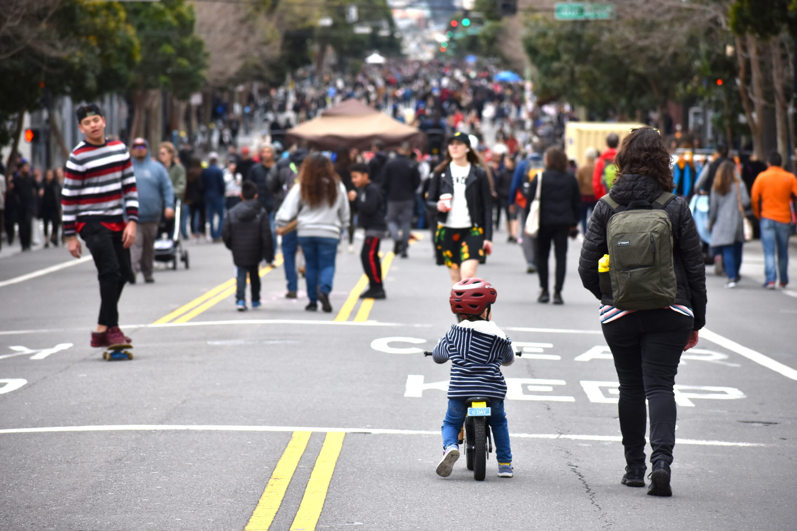
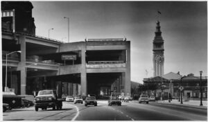
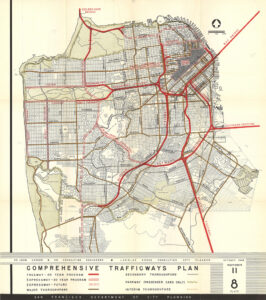
After World War Two, San Francisco, like other cities, made sweeping plans to adapt the city to mass automobility. The 1848 Trafficways Plan envisioned freeways throughout San Francisco. Freeways were bulldozed through neighborhoods. Residents in the path of the freeways organized and protested, and those protests grew stronger and more urgent as the freeway network expanded. Over 30,000 attended meetings and signed petitions in threatened neighborhoods. In 1959, to the surprise and chagrin of the State Department of Highways, San Francisco’s Board of Supervisors voted to cancel 75% of the proposed freeway routes through San Francisco. In 1961 the Supervisors cancelled plans for the Western Freeway through the Richmond and Sunset districts, and in 1966 the Supervisors, in a 6-5 vote, cancelled plans for a freeway through the Panhandle and Golden Gate Park.

The Embarcadero Freeway looking north from Howard Street. The Ferry Building is in the right of the photo.

The Freeway Revolt halted freeway construction in San Francisco, and for decades the City lived with the partial freeway network built in the 1950s, while freeway construction around the Bay Area and California continued.

In 1973, San Francisco adopted its first ‘transit first’ policy, and the City marked bus lanes on some City Streets. BART opened transbay service in 1974, and the Muni Metro light rail subway opened under Market Street in 1980. In the 1980s a proposal to remove the Embarcadero Freeway and replace it with a waterfront boulevard gained support. The growing dominance of container shipping had shifted maritime trade from San Francisco to Oakland, and removal of the freeway became part of plans to convert San Francisco’s historic but increasingly derelict piers into a vital public waterfront, and reconnecting the waterfront with the City. The Supervisors voted to remove the freeway in 1985, but the question was put to the voters in 1987, and was defeated.

San Francisco chooses a new road

The Embarcadero Freeway was badly damaged in the earthquake, and it was closed to traffic. The state’s highway engineers proposed replacing it, but Mayor Art Agnos championed removing the freeway and replacing it with a new waterfront boulevard. After months of debate, the Board of Supervisors voted 6-5 to remove the freeway. Demolition began in February 1991. Architect Dan Solomon observed:

On the night of 27 February 1991, the eve of its demolition, I walked the length of the top deck of the freeway … It was drizzling and dark, and it was like walking in Venice where the only sounds are footsteps and voices. For some reason there were lots of languages – Portuguese, German, Japanese, French, Chinese. People were silhouetted in the dark, just walking quietly, talking. As much as I had loved the views driving – ten thousand times, twenty thousand times, they were much more beautiful on foot, in the quiet.

On 27 February 1991 the automobile era ended. Now, even in California, people will talk about other ways to get around; about not having to get around so much: about towns, streets, public places, walking.

The Embarcadero Freeway was removed back to its junction with I-80, including a tangle of ramps around the Transbay Transit Terminal. The California legislature authorized turning over the state property under the freeway to San Francisco, and San Francisco agreed to fund completion and future maintenance of the surface roadways that replace the freeway.

The new Embarcadero boulevard followed the waterfront, and then turned southeast as King Street, which was widened into a boulevard after the earthquake. Removing an earthquake-damaged northern stub of I-280 freed the site where the Giants ballpark now stands, and new touchdown ramps were built several blocks east to connect the shortened freeway to King Street.

The northern end of the Central Freeway between Fell and Turk streets, including onramps from Turk and Gough and offramps to Franklin and Golden Gate, were closed after the quake, and demolished soon after. The remaining double-deck portion of the Central, connecting US 101 to Oak and Fell streets, needed repair but remained open to traffic while the City deliberated. The City appointed a citizen task force to develop and evaluate alternatives. The task force recommended that the freeway be demolished and replaced with a surface boulevard, and new freeway touchdown ramps built on the south side of Market. The task force were interested in removing the freeway further south of Market Street, both to avoid a freeway terminus on the City’s main civic boulevard and to take advantage of SoMa’s wider streets and long blocks to disperse some auto traffic, rather than concentrate it at a single intersection. Caltrans and the Mayor’s office forbade consideration of alternatives that removed or modified the steel portion of the freeway east of Mission Street, so the Market Street touchdown and Octavia Boulevard were recommended. Caltrans later closed the freeway west of Mission Street to remove the upper (southbound) deck. The traffic nightmare predicted by Caltrans and freeway boosters failed to materialize, strengthening the argument for freeway removal.

Pro-freeway activists and politicians put Prop K on the ballot in 1997, which called for retrofitting the freeway, and voters narrowly approved it. The following year, boulevard proponents put the boulevard alternative before the voters as Proposition E. Lawrence Ferlinghetti, then San Francisco’s poet laureate, gave a public address two weeks before the election, where he said

What destroys the poetry of a city?

Automobiles destroy it, and they destroy more than the poetry. All over America, all over Europe in fact, cities and towns are under assault by the automobile, are being literally destroyed by car culture. But cities are gradually learning that they don’t have to let it happen to them. Witness our beautiful new Embarcadero! And in San Francisco right now we have another chance to stop Autogeddon from happening here. Just a few blocks from here, the ugly Central Freeway can be brought down for good if you vote for Proposition E on the November ballot.

Proposition E was approved in November 1998. The following year there was a third referendum when freeway proponents revived the freeway retrofit proposal, and proposal was soundly defeated. The quake-damaged concrete portion of the freeway was demolished, and Octavia Boulevard and the new freeway touchdown ramps opened in 2005.

Take Action for a Livable City: Better Market Street and Parking Reform

Market Street by Madeleine Savit

In March, the San Francisco Board of Supervisors declared a Climate Emergency, calling for “immediate and accelerated action to address the climate crisis.”

We’re urging City government to walk its talk, and join a growing number of cities making bold moves to address the climate crisis – and become more healthy, livable, equitable, and green at the same time.

As the City’s climate technical report points out, a sustainable transportation mode shift – shifting trips from automobiles to walking, cycling, and public transportation – is the most effective local climate leverage point. Emissions from private cars and light trucks are the largest source of carbon emissions in San Francisco and California. Despite progress in many areas, transportation-related emissions continue to rise, threatening to undo California’s progress towards its climate protection goals.

The City’s goal is to increase the percentage of person-trips using sustainable transportation modes – walking, cycling, and public transit – from the current 54% to 80% by 2030.

Achieving a transportation mode shift of that size in just over a decade is ambitious – and necessary. Cars are the most space-inefficient mode of transportation, so mode-shifting means less congested streets and liberates public space for community uses and greener neighborhoods. Less auto traffic makes our streets safer, and can help reduce the rising number of auto-related deaths and injuries on City streets. Reducing automobile dependence makes us healthier – reducing air and water pollution in our neighborhoods, and increasing active transportation, aka walking and cycling.

Next week San Franciscans have two opportunities to support big moves to address the climate crisis and effect a sustainable mode shift.

Better Market Street

On Tuesday October 15, the SFMTA Board of Directors will consider whether to adopt the Better Market Street plan. Better Market Street calls for improving walking, cycling, and public transit on San Francisco’s busiest walking, cycling, and transit street. The plan will remove private cars from Market between Van Ness and The Embarcadero, which will reduce travel times and increase reliabilty for hundreds of thousands of daily Muni riders. It will also extend protected bicycle lanes along most of Market to create safer cycling.

Adopting the Better Market Street Plan and certifying the environmental report will allow SFMTA to make Market Street car-free by the end of this year, and begin construction of the first phase improvements in 2020.

The SFMTA Board meeting is at 1 pm on Tuesday, October 15 in City Hall Room 400. You can contact the MTA board by phone (415.701.4505) or email ([email protected]).

Parking Reform

On Thursday October 17, the Planning Commission will consider Supervisor Mandelman’s parking reform ordinance.

Evidence compiled for the Planning Department shows that reduced off-street parking in buildings is one of the most effective strategies for shifting towards sustainable modes of transportation, reducing auto traffic and pollution, reducing the cost of housing, making our streets greener and safer for walking and biking, and meeting our climate protection goals. 

Last year, the Board took a bold step of eliminating minimum parking requirements citywide. Supervisor Mandelman’s ordinance will take an important next step by updating and simplify the Planning Code’s off-street parking maximums, parking standards, and freight-loading requirements, and cleaning up, clarifying and better organizing the parking-related provisions of our Planning Code. The ordinance:

  • lowers the maximum amount of parking permitted in new buildings in the City’s densest and most transit-served neighborhoods, including the Market, Mission, Valencia, and Van Ness corridors, along the City’s light rail and rapid bus corridors, and Downtown and SoMa.
  • requires new above-ground parking for four or more cars to be built for easy conversion to other uses in the future.
  • restricts new new driveways on Valencia Street, and new parking lots along Market Street.
  • Requires accesible sidewalks and curbs on adjacent streets when new public or private parking lots are approved.

The Planning Commission hearing is at 1 pm on Thursday, October 17 in City Hall Room 400. You can find contact info for the Planning Commission on our advocacy page.

A Permanent Town Square in the Excelsior? 

Excelsior Action Group and Sunday Streets Bring the Vision to Persia Triangle on October 20

The Persia Triangle Pop-Up at Sunday Streets Excelsior. Photo by Young Chau

FOR IMMEDIATE RELEASE

Mary Strope

O (415) 344-0489

[email protected]

***PRESS RELEASE***

San Francisco – Excelsior residents have dreamed of creating a permanent town square and public mini park at the Persia Triangle, a site formed by the intersection of Mission Street, Ocean and Persia Avenues in the heart of the neighborhood, for years. As local efforts ramp up to make the community space a reality, the Excelsior Action Group (EAG) and Sunday Streets are transforming the space – currently an auto repair shop – into a pop-up park at Sunday Streets Excelsior, taking place on October 20 from 11am-4pm.

“It is important for our neighborhood to have a dedicated public space and Persia Triangle has been on our hearts and minds for a long time,” said Supervisor Ahsha Safai. “I am fully committed to working with the community and various City agencies to make the acquisition of Persia Triangle a reality.”

Trees from Friends of the Urban Forest, games from SF Parks Alliance, picnic benches, live music, and free activities will bring fun and greenery to the usually car-centric location. EAG recently assisted community members with the formation of Friends of Persia Triangle.

Along with Livable City — the nonprofit that produces Sunday Streets — the new group will be present at the pop-up to talk to neighbors about and advocate for the permanent open space.

Despite a high percentage of multi-generational families, the Excelsior has no public plazas and few open spaces. Though the neighborhood is bordered by Balboa and McLaren Parks, it lacks a central, accessible gathering space for residents. Currently, Persia Triangle only sees this transformation twice yearly at Sunday Streets Excelsior. However, Livable City and the Department of Children, Youth and Their Families (DCYF) held a pop-up in July, and SF Parks Alliance is exploring the possibility of a monthly activation to help build the culture and support around making the longtime dream a physical reality.

Open streets program Sunday Streets brings a mile of car-free open space twice yearly to the district, spanning Mission Street from Geneva to Silver Avenues and produces a season of ten annual car-free events citywide. EAG develops and sustains underserved commercial corridors in District 11 through small-business capacity building, public and private space activation, community real estate and city liaison services, and policy advocacy activities.

The Sunday Streets 2019 season is made possible by the following season sponsors: Bay Area Air Quality Management District (BAAQMD), San Francisco Department of Children, Youth & Their Families (DCYF), Mission Housing Development Corporation, San Francisco Department of Public Works (SFPUC), Genentech, Office of Economic and Workforce Development (OEWD), Sutter/CPMC, Baywheels, Clif Kid, iHeartMedia, Skip, Sutter/CPMC, iHeart Media, Jump Bikes and Xfinity/Comcast and event sponsors The Excelsior Collaborative, District 11 Office of Supervisor Ahsha Safai and Boosted

About Sunday Streets

Sunday Streets is a program of the nonprofit Livable City, presented in partnership with the San Francisco Municipal Transportation Agency and the San Francisco Department of Public Health and the Shape Up SF Coalition. Additional City support comes from the Department of Public Works, Recreation & Parks Department, SF Police Department, SF County Transportation Authority, San Francisco Mayor London Breed and her offices and the SF Board of Supervisors.

For more information about Sunday Streets, including the Sunday Streets event activity guide, visit: www.SundayStreetsSF.com. For information on Muni routes and vehicle access, call 511 or go to www.sfmta.com

Get in Touch

Staff Directory

Darin Ow-Wing, Executive Director
[email protected]

Jessica Tovar, Program Director
[email protected]

Sally Chen, Deputy Director
[email protected]

Tom Radulovich, Senior Policy Fellow
[email protected]

Isaac Santiago, Sunday Streets Program Manager [email protected]

Reina Terry, Program & Development Associate, reina@livablecity.org