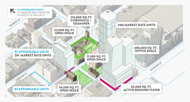
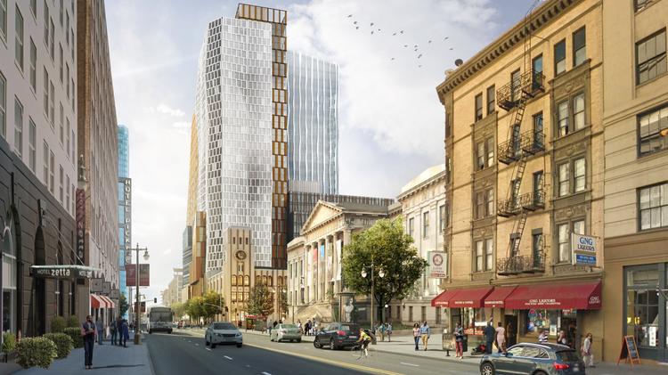
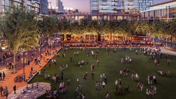
Two big private developments won important approvals in the last month – one from the voters, and the other from the Board of Supervisors. Voters approved Proposition D, approving a height limit increase for the Mission Rock Development on San Francisco’s waterfront, as well as a host of policies related to the development. The Board of Supervisors approved the 5M project, which will occupy the Chronicle Building and several adjacent buildings and parking lots at Fifth and Mission streets.
Mission Rock will occupy a large public trust property, zoned over two decades ago for open space, but leased since then by the Port to the Giants for a stadium parking lot. 5M includes portions of five city blocks, including parking lots and historic buildings. Both projects are radically larger than what the zoning for their sites permitted. Both had politically-connected development teams, including the Hearst media conglomerate and the San Francisco Giants baseball franchise. Each cited a years-long planning and development approval process to legitimize the project, and the exceptions they sought. Both promised big public benefits – open space, and that 40% of the housing they build will be permanently affordable (some of 5M’s affordable units will be off-site in separate projects).
Large projects like these have the potential to transform neglected areas in the city into livable urban neighborhoods, providing needed housing and work spaces while embracing sustainable transportation and building practices, affordability, complete streets, and green public places. 5M and Mission Rock will realize some of that potential, but so far have also fallen short in important ways, especially in transportation. Both projects demonstrated San Francisco’s lack of a cohesive sustainable development strategy, and the limitations of the City’s practice of planning-by-exception.
Incorporating Sustainable Transportation into Big Builds
Good planning creates projects that enhance sustainable transportation access and safety – walking, cycling, and public transit – for the benefit of the project and the neighborhood. Some transportation improvements can be planned and built at a project scale. Others, like transit capacity or bicycle networks, must be planned at a neighborhood or system level.
Both 5M and Mission Rock missed important opportunities to improve local transportation, and to embrace sustainable transportation strategies that reduce or mitigate the impact of auto traffic.
5M: Mega Development in a Mega Transportation Hub
5M is bounded by Mission, 5th, Howard, and 6th streets. Mission, Howard, and 6th are high-injury corridors – the 5% of San Francisco streets where over half of pedestrian deaths and serious injuries occur. Major transit lines run down Mission, and these must already navigate heavy traffic and large garages like that at 5th and Mission. Howard, one block away, is SoMa’s best westbound bicycle route. Fifth Street is part of the City’s bicycle network and is also a heavily-used transit corridor. 5M proposed some modest access improvements – wider sidewalks in places, and a new crosswalk to Mint Plaza. However, new loading zones and garage entrances on both 5th and Howard compromise bicycle safety on these important bike routes, and the added danger to pedestrians from additional traffic and right-turning vehicles is mostly unmitigated.
Livable City worked with other advocates, including Walk San Francisco and the San Francisco Bicycle Coalition, to insist that 5M reduce the amount of commuter and residential parking in the project, and thereby to reduce the traffic burden on adjacent streets. Last month 5M agreed to reduce parking in the project. Although 6th Street has a plan to improve pedestrian safety and provide cycle lanes, 5th, Mission, and Howard do not. In response, we met with the developers and SFMTA to outline a planning study for these streets to make walking and cycling safer, and to better accommodate local transit.
Mission Rock: Too Much Parking in an Over-parked Neighborhood
Notice anything missing from this picture or the campaign literature you likely received? Parking, and lots of it. Prop D proposed the Mission Rock development add over 3,000 parking spaces, including 2,300 in a 10-story parking garage occupying a full city block. This was proposed despite the fact that over 9,000 parking spots already exist within walking distance of the project. Most of these spaces go unused on evenings and weekends. Moreover, the neighborhood is served by Caltrain, the K-T and N Muni lines, and and bus rapid transit is planned for 16th Street.
The common refrain is that we need tens of thousands of parking spaces to accommodate the UCSF’s campus, the Warriors arena, and AT&T Park’s crowds. None of these developments, however, are heavily used 24 hours a day, every day. A neighborhood parking plan, together with improved walking, cycling, and transit access, would accommodate all the reasonable parking needs of Mission Rock development and the proposed Golden State Warriors arena without building more parking in Mission Bay. But the City doesn’t have a plan.
It’s possible that after environmental review and project approvals, the Board of Supervisors may realize that the transportation policies in Proposition D, especially those calling for massive parking structures, are bad for the neighborhood, nearby neighborhoods, and the environment. They may decide that housing and parks are a better use for waterfront public land in an increasingly crowded City.
Livable City has helped shape many neighborhood plans citywide, and we think it’s time to refresh the plan for Mission Bay. We will advocate for a parking and transportation strategy for the whole Mission Bay, since the current plan is almost two decades old. The uses currently proposed in the neighborhood – high-rise development on the Mission Rock site, a basketball arena, and office projects like the proposed Uber headquarters – are very different, and much more intensive, than what was originally studied.
Planning for Livable Neighborhoods
Both 5M and Mission Rock are located in parts of the city that have been the subject of multiple neighborhood plans. Yet in both cases, the projects are very different from what those plans call for. In neither instance was there an implementable plan for street design, or for sustainable transportation. The transportation shortcomings in these two projects point to big flaws in the way the City plans major projects.
5M is within the Planning Department’s Central SoMa Plan area, but the site was carved out and planning for it led by a separate agency, the Mayor’s Office of Economic and Workforce Development. The Central SoMa plan includes street plans for Folsom and Howard, but not 5th. In 2013, Livable City requested that a 5th Street plan be included in Central SoMa, but Planning refused. Planning for 5th Street improvements was promised in 2009 as part of the Market Street Place project approval, but the City has yet to collect the funds or start the plan. 5th Street is the eastern edge of the Eastern SoMa Plan, adopted in 2008, but that plan also neglected 5th Street. The Environmental Impact Report for 5M barely touched pedestrian safety, and didn’t address bicycle safety or access on 5th and Howard. Safety and access would be severely compromised if the development moved forward as planned. Last month, 5M agreed to fund a 5th Street study, which will finally bring 5th Street the attention it deserves.
The planning around Mission Rock is similarly fragmented. The project is on waterfront public land, within the jurisdiction of the Port of San Francisco, but the Planning Department also has land use authority. It is bounded on the west and south by the Mission Bay Redevelopment Area, which is governed by the Office of Community Infrastructure and Investment (OCII – formerly the San Francisco Redevelopment Agency). Planning, the Port, and OCII are overseen by separate commissions, with different policies and priorities around transportation, land use, and urban design. The Environmental Impact Report for Mission Rock is not complete, but, like 5M, it is taking a disconnected view of the project and its transportation needs and impacts, rather than planning Mission Rock and the proposed Golden State Warriors arena next door in the context of Mission Bay as a whole.
Downtown, SoMa, and Mission Bay will add thousands of new residents and new jobs in coming years. 5M and Mission Rock demonstrate how San Francisco’s piecemeal, fragmented, and reactive planning, especially transportation planning, require thorough reform. We need to update neighborhood plans – especially the Downtown Plan, the various SoMa plans, and Mission Bay Plan, to include complete streets, bicycle and pedestrian safety, and strategies to reduce auto traffic and congestion. Environmental review, as San Francisco currently practices it, is an expensive and time-consuming exercise that has repeatedly proven useless for improving pedestrian and bicycle safety, or devising sustainable transportation strategies for neighborhoods and projects.
The city needs to stop working in silos – neglecting the street or building next door – simply because it is outside the immediate project area. By creating or updating neighborhood plans, we can build neighborhoods with unique identities that still allow for growth, safe places for transit, cyclists and pedestrians, and open space. We continue to work with government and private partners to make good projects great for all citizens. As we move into 2016, Livable City will advocate for the City to renew these plans to ensure every neighborhood has a plan for the future.

