April 9, 2019 FOR IMMEDIATE RELEASE Mary Strope Communications Manager O (415) 344-0489 | mary@livablecity.org
PRESS RELEASE
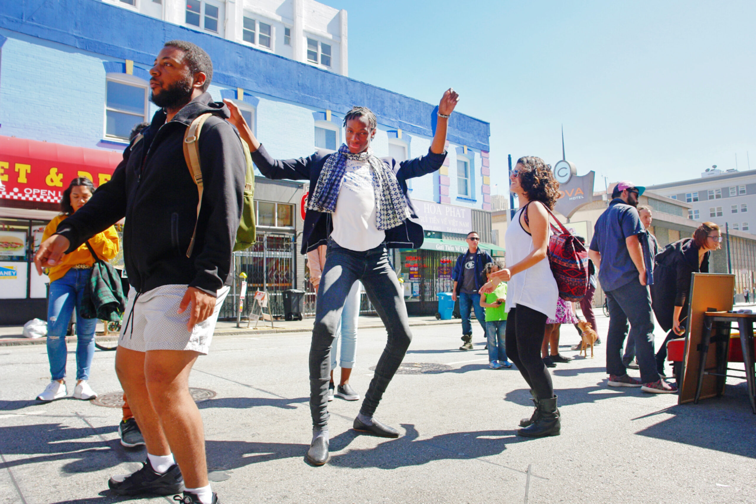
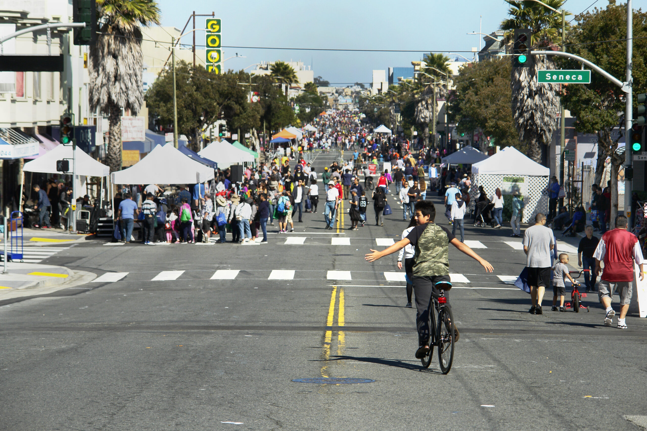
Sunday Streets Tenderloin Brings a Thai New Year Festival to Little Saigon – Plus Over a Mile of Free Activities, Music and Open Space For All
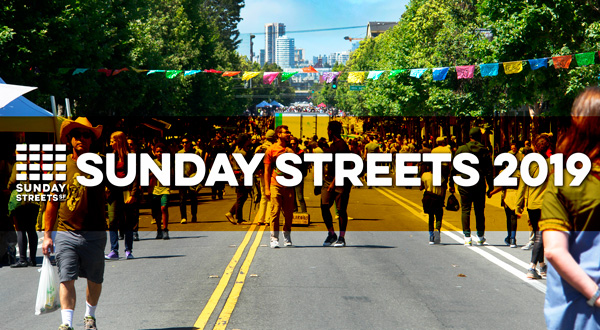
San Francisco – Sunday Streets brings car-free fun to the Tenderloin and Civic Center on April 14, transforming car-congested streets into open space with live musical performances, free activities and fun for the whole family on Larkin, Ellis and Jones Streets and Golden Gate Avenue from 11 a.m. to 4 p.m. New this year, enjoy the first annual San Francisco Thai New Year celebration in Little Saigon.
Two blocks of Larkin Street between Eddy and O’Farrell will transform into a cultural festival for a day of fun, food and celebration of San Francisco’s Southeast Asian communities, all taking place in conjunction with Sunday Street Tenderloin. Enjoy a stage, live bands, Muay Thai boxing demonstrations, traditional Southeast Asian dances and a Southeast Asian fashion show. Savor small bites from world-renowned Lers Ros Thai and other Tenderloin institutions, a Thai beer garden and a marketplace featuring neighborhood makers.
Bring kids for bounce houses and games at the festival or over a mile of free activities and open space as Sunday Streets transforms the Tenderloin into a temporary park for the day. At Civic Center, celebrate all things local with the 415 Day Stage and vendors. Bring kids for a Play Streets Pop-Up presented with Civic Center Commons, complete with lawn games, pickup basketball and SF Rec and Park’s Mobile Rock Climbing Wall. From 11 a.m. to 2 p.m., catch Awesöme Orchestra Collective in partnership with SF Public Library’s Main Branch.
Project Experts from the SFMTA will be on hand on to answer questions about safety improvements in the area. As a primary sponsor of all Sunday Streets events, neighborhood residents and visitors can enjoy direct access to transit planners and ambassadors dedicated to sustainable streets. And don’t forget to pick up the Explore Local Guide for a fun map of the Tenderloin to use all year long.
Inspired by the Ciclovía in Bogotá, Colombia, Sunday Streets is a series of free, fun open street events empowering local communities to transform one to four miles of car-congested streets into car-free community spaces for kids to play, seniors to stroll, organizations to connect and neighbors to meet. Over a mile of cultural performances, health resources, live music and open space provides free opportunities for all at ten yearly events.
Nonprofit Livable City runs both Sunday Streets and Play Streets, a program empowering neighbors to transform their block into an accessible, car-free open space on a regular basis. Both programs are sponsored by the SFMTA and other City agencies, and Sunday Streets would not be possible without crucial services like Muni bus re-routing or traffic control officers for public safety.
Small businesses, residents, nonprofits and local groups bring activities, volunteers and performances to the car-free routes, with each contributing a distinctive character and energy to the day. A local hire program employs San Francisco residents for outreach and event-day support. Transforming miles of car-dominated City streets into open space is possible through the collaboration and hard work of hundreds of volunteers, neighbors, nonprofits and small businesses. Donate, exhibit, volunteer or sponsor Sunday Streets in 2019 to be part of a sustainable, greener and more accessible future. For more information, visit www.SundayStreetsSF.com.
The Sunday Streets 2019 season is made possible by the following season sponsors: Bay Area Air Quality Management District (BAAQMD), San Francisco Department of Children, Youth & Their Families (DCYF), Mission Housing Development Corporation, San Francisco Department of Public Works (SFPUC), Genentech, Office of Economic and Workforce Development (OEWD), Sutter/CPMC, Ford GoBike, iHeartMedia, Skip, Sutter/CPMC, iHeart Media, Jump Bikes and Xfinity/Comcast
About Sunday Streets Sunday Streets is a program of the nonprofit Livable City, presented in partnership with the San Francisco Municipal Transportation Agency and the San Francisco Department of Public Health and the Shape Up SF Coalition. Additional City support comes from the Department of Public Works, Recreation & Parks Department, SF Police Department, SF County Transportation Authority, San Francisco Mayor London Breed and her offices and the SF Board of Supervisors.
About Livable City Livable City is dedicated to increasing affordable housing, improving transportation, land use, open space, and environmental policies, and supporting grassroots initiatives to make San Francisco a safer, healthier, and more accessible city. For more information on Livable City, visit: https://livablecity.org. For more information about Sunday Streets, including the Sunday Streets event activity guide, visit: www.SundayStreetsSF.com. For information on Muni routes and vehicle access, call 511 or go to www.sfmta.com
With cars so deeply ingrained in both people’s everyday lives and the city’s infrastructure, it can be difficult to imagine a future without the automobile. Roads are built for them, giant parking structures exist countrywide to store them, and even sidewalks regularly give way to driveways.
But with every new climate change report, it’s clear – cars are not part of a sustainable future. In California, the largest source of carbon emissions comes from driving. And despite the state’s efforts to lead in environmental policy, emissions from greenhouse gases have been on the rise for the past few years.
As we saw with the story of Ciclovía – Bogotá, Colombia’s open street program and the largest and oldest one worldwide – open streets cannot just stand on their own to create change. Even one day a week where almost an entire city of 8 million people gain access to car-free streets has not solved the pollution and traffic problems caused by cars in Bogotá.
But open streets programs remain a powerful way of modeling a car-free future – exposing people not just to what human-scale public space looks like, but what sustainable transportation feels like. Beyond a fun way to exercise and socialize, they provide a model for what could be.
Since fewer people are driving, open street programs help clear the air – LA’s CicLAvia improves air quality by reducing ultrafine particles in the air by over 20 percent, while a “study conducted in Bogotá reveals that particulate matter along the city’s Ciclovía route was 13 times higher on a regular weekday than on a Sunday.”
If a single day of less driving can significantly improve the air quality (albeit temporarily), then permanently establishing car-free streets could provide ongoing positive effects on air quality.
Beyond air quality, open streets programs re-introduce neighborhoods to residents as places to travel sustainably – either on foot, bike or scooter. Studies have shown that open streets don’t just provide needed exercise, they encourage exercise outside of the events. At open street events like Sunday Streets, that exercise largely coincides with sustainable transportation. When there is no option to take a gas-guzzling vehicle, attendees can see how walkable, bikeable and rollable their streets really are.
Despite better-than-average bike infrastructure and public transit, cars are largely the mode of transport in San Francisco, and often the fastest and most accessible way to get around. It’s a reflection of the way our city’s infrastructure has shifted to serve the automobile first.
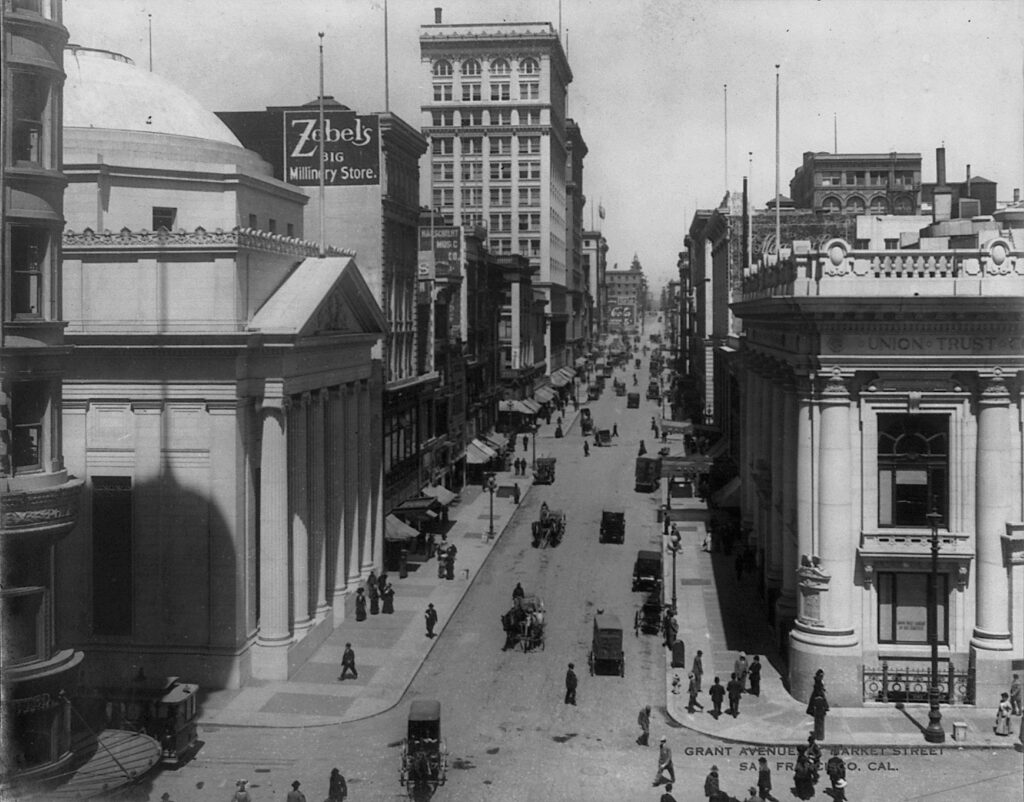
It wasn’t always that way. In fact, for most of the country’s history, communities were centered around other things – bodies of water, train stations, or communal gathering spaces like squares or marketplaces. In older cities, many of the roads we drive down today started as walking trails created over centuries by Native peoples.
New York City’s Broadway is one of the most famous examples, which began as a trail of the Canarsee Indians of the Lenape following a ridge and stretching from one end of Manhattan to the another.
While human beings have been carving roads and paths for eons, it’s easy to forget that cars are quite new. Before automobiles, roads were shared spaces – open to pedestrians, vendors and modes of transport like horses and buggies. Children played in the streets freely and jaywalking just didn’t exist. Photos from the time show streets full of people and children traveling, eating, playing, socializing, shopping and crossing every which way.
The Automobile Land Grab & The Invention of Jaywalking
With the production of the first affordable, fast automobile – Henry Ford’s Model T- a calculated shift towards a car-focused society began to take place, spurred on by the automobile industry’s profit-seeking motives. Charles Hayes, president of the Chicago Motor Club, decided “it was time to target not the behavior of cars—but the behavior of pedestrians.”
A public relations campaign shaming jaywalkers (a newly-created term) and pedestrians placed the blame squarely on humans at a time when many were deeply troubled by the deaths caused by auto accidents. Interestingly, ‘jaywalker’ came from the word from the slang ‘jay’, meaning ‘ignorant bumpkin’. Before it was used to describe wayward pedestrians, the term actually described unruly drivers – “A jay driver is a species of the human race who, when driving either a horse or an automobile, or riding a bicycle on the streets, does not observe the rules of the road. It is the custom of the jay driver to drive on the wrong side of the street.”
The decade also saw the rise of planned “residence parks” – suburban-style neighborhoods like St Francis Wood – designed for drivers, not pedestrians. “Apartment houses, groceries, laundries, saloons, stables, or undertaking establishments” were not permitted in these decidedly non mixed-use communities, where wealthy residents were expected to drive to services and retail.
Invasion of The Freeway
By 1948, the city’s Trafficways Plan envisioned a city criss-crossed with eight freeways, from the Mission to the Sunset. Redevelopment was on its way as modernist architects and planners envisioned a car-dominated city of the future, where buildings were massive and set far back from the streets. Pedestrians were relegated to walkways, often above or below street level, and planners shifted land use to accommodate parking spaces and structures.
The most infamous redevelopment project was the razing of a 36-block zone in the Western Addition, a plan first submitted in 1947. The planning department’s intention was clear: to create a whiter, wealthier neighborhood from the dense, culturally thriving African American district (which was also one of the city’s most racially integrated and diverse), and demolish Victorian homes in favor of scattered large, setback developments.
“It was mutually-assured destruction,” Livable City Executive Director Tom Radulovich said of the new modernism. “Streets got more dangerous, and buildings withdrew from the street. It eroded city life.”
The plan decimated the community, including its world-class jazz scene, razing blocks of old Victorians and leaving empty lots in their place, some of which lingered into the 70s and 80s. Though residents were promised a right to return, few were actually given the option. The area’s significant Japanese population, who’d been forced out and placed in camps during World War 2, were paid tribute in a modernized Japantown, bordered by the brand-new, high-speed and highly unwalkable Geary Boulevard. But few people of Japanese descent moved back to the new area, with its stylized architecture, shopping malls and raised pedestrian walkways.
Today, San Francisco, like many American cities, still suffers the negative effects of the era’s redevelopment projects. Lower Fillmore Street, rebuilt with giant high-rises and large blocks of public housing, failed to provide the social cohesion – and even volume of housing – the old neighborhood had, and efforts to revive the commercial corridor continue to be a challenge, especially in an age of vast wealth inequality and racial disparities.
The Bayview also changed when the 101 freeway replaced the old Bayshore Highway, transforming a bucolic beachside neighborhood served by streetcars to a traffic thoroughfare. Though it’s home to the T, the city’s first light rail line in half a century, the line’s service has been spotty, failing to serve the area’s residents – many of them the descendants of African Americans displaced during Western Addition’s redevelopment. Other major traffic thoroughfares, like San Jose Avenue, are not freeways per se, but were established to cut through the city to accommodate cars, and are decidedly not pedestrian-friendly.
With their centrally located commercial corridors, walkable neighborhoods built in the pre-car era remain the most desirable today. Others, like Parkmerced with its high-rise clusters bordering high-traffic thoroughfares, show the legacy of modernism.
Developers still favor – and continue to build – giant, boxy high rises, but many of the large, bottom-floor retail spaces make up long-term vacancies, further eroding city life. Though malls like the Sunset’s Stonestown are losing anchor retailers, and Union Square is dotted with vacant buildings, a 250,000-square-foot mall was constructed on central Market Street in 2010 in an effort to revitalize the area. Today, the mall sits empty, anchored only by a parking garage.
Before cars took over the bustling city of San Francisco, people walked and used public transit to get around. A 1927 San Francisco study found that “streetcars were used by 70 percent of the people depending on some kind of transportation to get downtown, while only a quarter used passenger cars, but the latter made up 61 percent of vehicular traffic as compared to 11 percent for the streetcars”. The second level of the Bay Bridge was devoted to light rail, which came to a stop in 1958.
From Neighbors to Poet Laureates: San Francisco Fights The Car
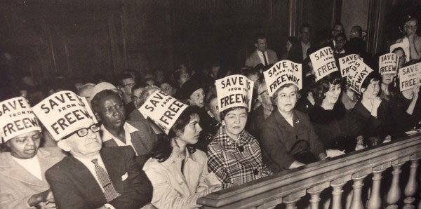
Freeway protesters in City Hall, 1966 Photo: San Francisco Chronicle
Resistance followed redevelopment, and similar projects in the Mission were halted due to opposition. The resistance didn’t stop at car-focused city planning, though, and in the 1950s and 60s a series of protests known as the Freeway Revolt put a stop to the Trafficways plan.
Many people resisted automobile dominance. In the 20s, the San Francisco electorate twice defeated amendments to build underground parking in public parks. Still, the City pushed on, eliminating trolly and cable car lines in favor of the buses that get stuck in car traffic.
BART began providing an efficient public transit alternative to City buses in 1972, at time when more and more people were advocating for environmental sustainability. With only eight stops in San Francisco, the finished system was a far cry from the original proposal, which served far more SF neighborhoods, as well as Marin County. The following year, SFMTA adopted a “transit-first” policy it still has today, though few political leaders have signed on to make the policy a reality.
The 1989 Loma Prieta earthquake changed the landscape yet again, damaging both the Embarcadero and Central Freeways. While the waterfront-hugging Embarcadero Freeway quickly came down, the Central Freeway’s fate was unclear. Cycling and livability advocates were gaining steam, and the issue was put to the voters three times.
“What destroys the poetry of a city? Automobiles destroy it, and they destroy more than the poetry,” Lawrence Ferlinghetti said in his inaugural address as Poet Laureate of San Francisco in 1998.
“All over America, all over Europe in fact, cities and towns are under assault by the automobile, are being literally destroyed by car culture. But cities are gradually learning that they don’t have to let it happen to them.”
Ferlinghetti urged San Franciscans to vote to replace the Central Freeway with a boulevard. A Central Freeway Citizens Advisory Council was established, and ultimately, city street Octavia Boulevard replaced the big, bulky freeway’s right-of-way.
1999 saw the city’s first “road diet” on Valencia Street, transforming the street with new bike lanes and creating a model that would be followed, albeit piecemeal, in street improvements citywide. Widening sidewalks, adding bulbouts, greening with parklets, trees and plants and creating protected better biking and transit infrastructure have become the best practice to create walkable, bikeable streets.
Today, the movement to pedestrianise city streets and reclaim them from cars coincides with movements for transit, environmental and economic justice. After many years, Livable City’s fight to eliminate minimum parking requirements saw a victory this year. While cars still dominate – and the rise of TNCs have dumped thousands more daily on city streets – both major boulevard Market Street and the Mission’s Valencia are continually brought up as ideal streets for year-round car-free spaces. SFMTA has begun to study the feasibility of car-free streets that would be open to pedestrians, bicyclists and city buses. But such a shift to a multi-modal future isn’t easy.
“Optimizing streets for cars is pretty simple,” said Radulovich. “But if you really think multi-modal, you need a much more complex and nuanced vision. Cities are complex, and you have to approach them with a certain level of humility.”
FOR IMMEDIATE RELEASE (415) 344-0489 mary@livablecity.org
***PRESS RELEASE***
San Francisco – Sunday Streets comes to the Excelsior district on March 31 from 11am-4pm, transforming Mission Street from Silver to Geneva Avenue into on open street with free activities, live music, health resources, a local goods Market Square, Picnic Grounds and more.
“Sunday Streets brings together San Franciscans from all walks of life to enjoy our city’s open spaces and strengthen our communities,” said Mayor London N. Breed. “Our city is known for its beauty and its landmarks, but what really makes it great is our people. Sunday Streets gives our residents the chance to enjoy together the best of what San Francisco has to offer.”
Visit Activity Hubs at Cotter, France and the Persia Triangle, where residents of all ages can experience a pop-up community park and Petsville with a dog adoption event and SFPD’s equine unit. At France Street, enjoy a Market Square and Picnic Grounds, and pick up a Common Cents Passport at a Sunday Streets Info Booth to get stamped (and win prizes from!) local businesses. And don’t forget to pick up the Explore Local Guide for a fun map of the ‘hood you can use all year long.
Inspired by the Ciclovía in Bogotá, Colombia, Sunday Streets is a series of free, fun events empowering local communities to transform one to four miles of car-congested streets into car-free community spaces for kids to play, seniors to stroll, organizations to connect and neighbors to meet. Over a mile of cultural performances, health resources, live music and open space provides free opportunities for all at ten yearly events.
Nonprofit Livable City runs both Sunday Streets and Play Streets, a program empowering neighbors to transform their block into an accessible, car-free open space on a regular basis. Both programs are sponsored by the SFMTA and other City agencies, and Sunday Streets would not be possible without crucial services like Muni bus re-routing or traffic control officers for public safety.
Project experts from SFMTA and Vision Zero will be on hand throughout the season, providing neighborhood residents and visitors direct access to transit planners and ambassadors dedicated to sustainable streets.
Small businesses, residents, nonprofits and local groups bring activities, volunteers and performances to the car-free routes, with each contributing a distinctive character and energy to the day. A local hire program employs San Francisco residents for outreach and event-day support.
Transforming miles of car-dominated City streets into open space is possible through the collaboration and hard work of hundreds of volunteers, neighbors, nonprofits and small businesses. Donate, exhibit, volunteer or sponsor Sunday Streets in 2019 to be part of a sustainable, greener and more accessible future. For more information, visit www.SundayStreetsSF.com.
Sunday Streets 2019 Season Schedule
March 10 – Mission 1
March 31 – Excelsior 1
April 14 – Tenderloin 1
May 5 – Bayview/Dogpatch
June 9 – Sunset/GGP
July 14 – Mission 2
August 18 – SoMa
September 8 – Tenderloin 2
September 22 – Western Addition
October 20 – Excelsior 2
The Sunday Streets 2019 season is made possible by the following season sponsors: Bay Area Air Quality Management District (BAAQMD), San Francisco Department of Children, Youth & Their Families (DCYF), Mission Housing Development Corporation, San Francisco Department of Public Works (SFPUC), Genentech, Office of Economic and Workforce Development (OEWD), Sutter/CPMC, Ford GoBike, iHeartMedia, Skip, Sutter/CPMC, iHeart Media, Jump Bikes and Xfinity/Comcast
About Sunday Streets
Sunday Streets is a program of the nonprofit Livable City, presented in partnership with the San Francisco Municipal Transportation Agency and the San Francisco Department of Public Health and the Shape Up SF Coalition. Additional City support comes from the Department of Public Works, Recreation & Parks Department, SF Police Department, SF County Transportation Authority, San Francisco Mayor London Breed and her offices and the SF Board of Supervisors.
About Livable City
Livable City is dedicated to increasing affordable housing, improving transportation, land use, open space, and environmental policies, and supporting grassroots initiatives to make San Francisco a safer, healthier, and more accessible city. For more information on Livable City, visit:https://livablecity.org. For more information about Sunday Streets, including the Sunday Streets event activity guide, visit:www.SundayStreetsSF.com. For information on Muni routes and vehicle access, call 511 or go to www.sfmta.com
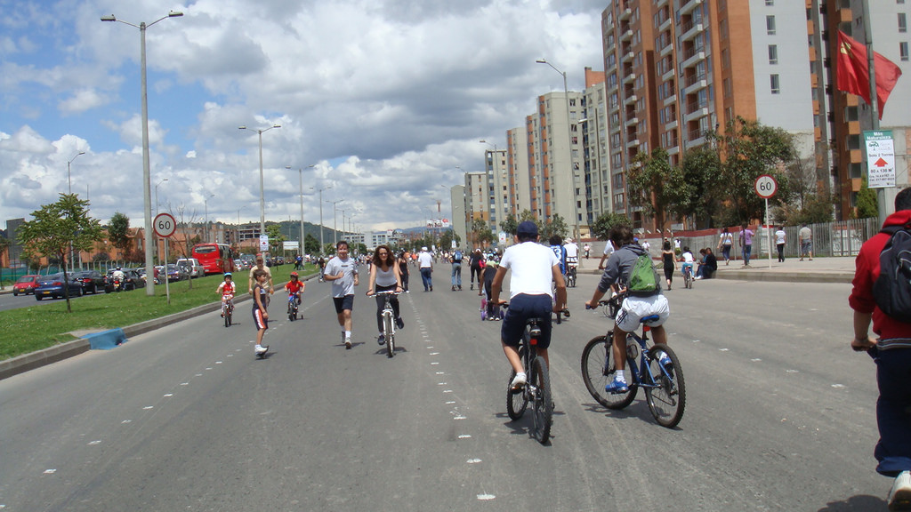
In 1974, Bogotá, Colombia began an experiment that would help shape a worldwide movement. That year, bicycling and recreation advocates piloted a program that closed city streets to cars to open them up for cycling and recreation.
“When I came back home to Bogotá, I was shocked to see that we Colombians were following the American path of urban development. Cars and more cars. One person, one car. It was obvious that this was not going to lead to a livable city, “ original Ciclovía organizer Jaime Ortiz Mariño told Bicycling Magazine.
In the 1990s and early 2000s, Mayor Enrique Peñalosa and his brother, parks commissioner Gil Peñalosa, increased the route to 70 miles, creating the expansive, nearly-citywide Ciclovía enjoys today. City parks are also opened up during the events so citizens can benefit from free exercise classes, and numerous studies have been conducted on the positive public health impacts. In economically stratified cities, open streets improve social connection too, providing a space all people can come together, regardless of wealth or status.
Nearly two million people turn out for Ciclovía, which takes place every Sunday and most holidays from 7 a.m. to 2 p.m. Though it has faced some challenges – including a congressman who tried to outlaw the program, saying it led to car traffic – the event has become an international touchstone and the inspiration for almost every open street program today, including Sunday Streets. The word, meaning “bike path” or “cycle way” has become synonymous with open streets.
As the fourth-largest city in Colombia, Bogotá is a sprawling industrial and economic center, with nearly 8 million inhabitants. It’s so crowded that car travel is restricted via license plate during peak hours, and heavy industry, vehicle traffic and a mountainous location lead to poor air quality.
But Bogotá is also a city shaped by Ciclovía and its champions, with over 200 miles of bike paths, and a city mandate that all new streets include bike lanes.
The transit and sustainability issues the city still faces point to the need for policy and legislation to work hand-in-hand with actionable interventions. But the success and permanency of a program many never imagined would succeed shows that a major metropolis can create mode shift, transforming car-dominated streets on a massive, nearly citywide scale weekly. As we envision a sustainable future, Ciclovía is a reminder that a city can thrive without cars on a scale few would have ever thought possible.
How did a dense, car-dominated, 49-square-mile city with multiple freeways launch the country’s largest open streets program?
Now in its 11th year, Sunday Streets San Francisco continues to expand its routes and programming to provide car-free community space for all.
Learn the story of how Sunday Streets got off the ground – and into the streets!
By Marynoel Strope
The First Year
In 2008, then-San Francisco Mayor Gavin Newsom decided it was time to address two major public health crises. Reports showed chronic disease on the rise locally, especially among people of color and low-income communities lacking access to parks, gyms and open space, while fossil fuel consumption led to climate change, threatening public health worldwide. Together with public health and sustainability advocates from across the city, he landed on open streets as the solution and piloted the very first Sunday Streets that year.
The first-year pilot provided 4.5 miles of temporary car-free space along the waterfront between the Bayview and Chinatown during two dates in August and September. It was inspired by Bogotá, Colombia’s Ciclovía, the world’s longest-running and premiere open streets program.
San Franciscans, especially families, turned out for the car-free events that provided miles of safe, recreational space in increasingly traffic-dominated roadways. What’s more, open streets created a model for a sustainable future, allowing residents to see their streets as public spaces and envision a world not reliant on fossil fuels.
“We have created a new tradition in San Francisco that will improve our quality of life for years to come,” Newsom said after the first event.
Newson presented the Sunday Streets pilot along with the Shape Up SF Coalition, a group comprised of policy nonprofit Livable City, SF Department of Public Health (DPH), SF Department of Children, Youth and their Families (DCYF), SF Bicycle Coalition, WALK SF, the YMCA and many more public health and sustainability advocates.
“It really was a citywide push with community partners, side by side and hand in hand,” said DPH Senior Health Program Planner Christina Goette of the program’s first year.
In transportation terms, it was a blank canvas for advancing mode shift, creating a space that made walking, biking and public transit the best (and only) option to take along the waterfront those two days in 2008. For the first time in San Francisco, the city and state’s largest source of greenhouse gas emissions – automobile traffic – was curbed on a large scale for public health.
Growing Up
In 2009, Newsom declared Sunday Streets permanent as it rolled out new long routes on 24th Street in the Mission, the waterfront and multiple Great Highway dates. In 2010, the program expanded to include routes dedicated to neighborhoods like the Tenderloin and Bayview (see the route history below). Routes have changed over the years due to logistics and community feedback, but all have been a minimum of one mile in length and aim to become permanent staples in the neighborhood, with many now enjoying a spring and fall session of Sunday Streets.
A study released in 2011 from Dr. Susan Zieff, Professor of Kinesiology at SF State University, showed the positive health impacts of the events – attendees not only got their weekly exercise on the mile-plus routes, but 25 percent reported a positive change in their overall physical activity. With data to back it up, Sunday Streets could now confidently claim more than just fun in the sun and had the legs of a real public health intervention.
The Leaders
In a field usually dominated by men, female program directors shaped the course of Sunday Streets. Susan King set the program on its path, choosing Livable City, led by Executive Director Tom Radulovich, as the program’s day-to-day operator. King continues to advocate for sustainability and open streets across the Bay Area.
Beth Byrne followed King, increasing outreach efforts and establishing the program as one of the City’s exemplary models for neighborhood notification. The City recognized December 8, 2015 as Beth Byrne Day in San Francisco for her service and advocacy in the city. Liza Pratt came after Byrne, refining the logistics infrastructure that informs the successful public/private partnership the program relies on today.
Current Programs and Development Director Katy Birnbaum is the first woman of color to lead Sunday Streets, and her focus on collaboration has expanded both community engagement and culturally relevant programming at Sunday Streets. Working closely with residents and stakeholders – from faith leaders to local merchants to cultural districts – Birnbaum’s emphasis isn’t just about bring resources to underserved neighborhoods, but about helping neighbors realize the resources within their own communities.
An Institution Is Made
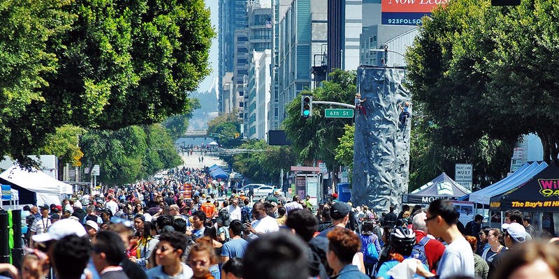
In 2018, the program celebrated a decade of open streets with a landmark 10 events across six neighborhoods adding its first new route in five years on Folsom Street in SoMa, which featured the first-ever Sunday Streets food and goods marketplace produce by SOMA Pilipinas’ Undiscovered SF Night Market in celebration of the district’s historic Filipino population.
What was once a city pilot project was now a San Francisco institution with a mission to foster public health and community-building, and inspire people to think differently about their streets as public spaces.
Today, Sunday Streets provides free recreation and health resources and over 15 miles of open streets yearly during ten annual events.
January 31st, 2019
FOR IMMEDIATE RELEASE
Mary Strope
(415) 344-0489
mary@livablecity.org
***PRESS RELEASE***
Sunday Streets Brings Over 15 Miles of Temporary Parks to San Francisco
San Francisco – Livable City is excited to announce the 2019 season of Sunday Streets, the country’s largest open streets program, with ten citywide events across San Francisco from March to October. Join the international open streets movement – the magic begins with Sunday Streets Mission on March 10.
Inspired by the Ciclovía in Bogotá, Colombia, Sunday Streets is a series of free, fun events empowering local communities to transform one to four miles of car-congested streets into car-free community spaces for kids to play, seniors to stroll, organizations to connect and neighbors to meet.
“Sunday Streets is part of a global open streets movement,” said Programs Director Katy Birnbaum. “Across the world, people are reclaiming their streets from cars and opening them up to the community. It’s about public health, free recreation, meeting your neighbors and envisioning a future where public space is for people, not auto traffic.”
Sunday Streets free events feature active play games, cultural performances, health resources, live music and more from 11am-4pm in diverse neighborhoods across the City, including the Mission, Excelsior, Tenderloin, Bayview and Dogpatch, Outer Sunset, Western Addition and newest route, SOMA.
Nonprofit Livable City runs the program, and is sponsored by the SFMTA and other City agencies. Sunday Streets is made possible with crucial services like Muni bus re-routing or parking control officers for public safety. Project experts from SFMTA and Vision Zero will be on hand throughout the season, providing neighborhood residents and visitors direct access to transit planners and ambassadors dedicated to sustainable streets.
Small businesses, residents, nonprofits and local groups bring activities, volunteers and performances to the car-free routes, with each contributing a distinctive character and energy to the day.
For local businesses, Sunday Streets offers the fun, reusable Explore Local map, the Common Cents Passport for brick-and-mortars and a Market Square in select neighborhoods featuring local vendors and makers. A local hire program employs San Francisco residents for outreach and event-day support.
“Sunday Streets shows sustainable transportation in action,” said SFMTA Director of Transportation Ed Reiskin. “Walking or biking the car-free route and taking public transit to get there is a healthful, fun and environmentally friendly way of getting around the City.”
Transforming miles of car-dominated City streets into open space is possible through the collaboration and hard work of hundreds of volunteers, neighbors, nonprofits and small businesses. Donate, exhibit, volunteer or sponsor Sunday Streets in 2019 to be part of a sustainable, greener and more accessible future. For more information, visit SundayStreetsSF.com.
The Sunday Streets 2019 season is made possible by the following season sponsors: Bay Area Air Quality Management District (BAAQMD), San Francisco Department of Children, Youth & Their Families (DCYF), Office of Economic and Workforce Development (OEWD), Sutter/CPMC, Golden State Warriors, iHeartMedia, Scoot, Xfinity/Comcast and Bi-Rite. Sunday Streets also thanks the following event sponsors: Mission Housing Development Corporation, Dolby and Wu Yee Children’s Services and is excited to welcome these exhibitors: Provident Credit Union, Farm Fresh to You / Capay Organic and Scoot.
About Sunday Streets
Sunday Streets is a program of the nonprofit Livable City, presented in partnership with the San Francisco Municipal Transportation Agency and the San Francisco Department of Public Health and the Shape Up SF Coalition. Additional City support comes from the Department of Public Works, Recreation & Parks Department, SF Police Department, SF County Transportation Authority, San Francisco Mayor London Breed and her offices and the SF Board of Supervisors.
About Livable City
Livable City is dedicated to increasing affordable housing, improving transportation, land use, open space, and environmental policies, and supporting grassroots initiatives to make San Francisco a safer, healthier, and more accessible city. For more information on Livable City, visit: https://livablecity.org. For more information about Sunday Streets, including the Sunday Streets event activity guide, visit: www.SundayStreetsSF.com. For information on Muni routes and vehicle access, call 311 or go to www.sfgov.org/311.
On December 21, the Mayor signed Supervisor Jane Kim’s ordinance eliminating minimum parking requirements citywide. The ordinance goes into effect on January 20.
In October, the City’s Planning Commission unanimously recommended removing citywide parking requirements as part of their review of legislation to limit new driveways along the City’s most important transit, walking, and cycling streets. Given the choice of adding more caveats to the Planning Code’s parking exceptions or eliminating minimums, the commission opted to recommend doing away completely with minimum requirements. Supervisor Kim agreed to act on their strong recommendation. The legislation was heard twice at the Board of Supervisors’ Land Use and Transportation Committee, with City and Bay Area environmental, sustainble transportation, and housing advocates – Livable City, Walk San Francisco, SF Bicycle Coalition, Transform, SPUR, Housing Action Coalition, and YIMBY Action – testifying in favor of the legislation, along with the City’s Planning Department, SFMTA, and Transportation Authority. At the full board, supervisors Kim, Brown, Mandelman, Peskin, Ronen, and Tang voted in favor.
Recent research continues to confirm what wise urbanists and planners have known for decades. Minimum parking requirements increase auto traffic in cities, and with it pollution and congestion. Minimum parking requirements make cities less healthy and less sustainable. Private cars are now the largest source of greenhouse gases in California, and an increasing one. Minimum parking requirements make housing more expensive to build, to rent, and to buy. Minimum parking requirements replace storefronts, walk-up housing, front gardens, and street trees with garage doors and driveways, making our neighborhoods and sidewalks less safe, less accessible, less green, and less appealing for people walking, cycling, and riding transit, particularly seniors, children, and people with disabilities.
Minimum parking requirements are an anachronism, a relic of the post-World War 2 project to retrofit walkable, compact, and transit-rich cities like San Francisco for domination by the automobile. The automobile-obsessed planning of that era imposed parking requirements, bulldozed freeways through city centers and urban neighborhoods, narrowed sidewalks and widened neighborhood streets into traffic sewers, tore up streetcar tracks, and displaced homes and businesses to build parking lots and garages.
That 1950s project was disastrous for cities, and citizens rose up to reclaim their streets and neighborhoods. San Francisco’s freeway revolt from 1959 to 1966 stopped urban freeway construction, and the City removed the earthquake-damaged Embarcadero and Central freeways after the 1989 quake. In the 1960s San Franciscans voted to build BART and the Muni Metro under Market Street, and later voted to rebuild streetcar lines, extend Caltrain, and expand and improve bus and ferry service. In the 1970s, the city began successful experiments with neighorhood traffic-calming, and started to install bicycle lanes in the 1990s. For decades the City has embraced, and affirmed and reaffirmed at the ballot box, a transit-first policy and a multi-modal transportation strategy that invests in transit, walking, and cycling and seeks to keep auto traffic in check.
Minimum parking requirements are incompatible with the livable, walkable, green, and sustainable urban future that San Franciscans prefer. Since the 1970s, the City has chipped away at the strict minimum parking requirements imposed in the 1950s, first Downtown and then outwards along some of the City’s many bus and rail corridors. The incremental approach has been successful. Neighborhood plans removed parking requirements in some places, while Livable City has worked with Supervisors to remove minimum requirements in many more neighborhoods, and for specific uses and circumstances. In 2007 voters overwhelmingly rejected Proposition L, which would have re-imposed minimum parking requirements outside the Downtown. In the past few years, the City has exempted accessory dwelling units and projects with increased affordability from minimum requirements citywide.
When eliminating minimum parking requirements is discussed, some people hear “ban on cars”, and start arguing why they or other people need a car for this or that, or how transit, walking, and cycling aren’t convenient enough or safe enough. Removing minimum parking requirements isn’t a ban on parking and driving. It makes automobility a choice rather than a government mandate. About a third of San Francisco households are car-free, and the majority of new households are car-free. Households who choose to do without a car can avoid the cost of buying, maintaining, and storing a car. Keeping minimum parking requirements in place does nothing to improve sustainable transportation options, and, by increasing traffic congestion and eroding the safety and utility of sustainable modes, makes the entire transportation system work worse. Removing parking mandates complements expanding sustainable transportation options, and better managing curb parking and loading. Relaxing parking requirements can even make living with cars easier, by reducing traffic congestion and turning unused driveways back into curb parking spots.
Reducing parking requirements is a national movement, as Strong Towns’ interactive map illustrates. San Francisco wouldn’t be the first US city to eliminate minimum parking requirements citywide – Hartford, Connecticut eliminated them last year. Finally eliminating minimum parking requirements would make San Francisco a progressive leader in the movement to reclaim cities for people, and in addressing the City’s escalating crises of housing affordability and automobile congestion, and easing the linked global environmental crises caused by automobile dependence.
The results of the November 6 election are mostly counted.
The big national news is that the Democratic Party will control the House of Representatives for the next two years, breaking the Republicans’ monopoly on national government.
Democratic control of the House will likely slow, or even stop, Republicans’ unprecedented attempts to dismantle laws that protect the environment and public health, and reduce federal funding and programs for housing and public transportation.
Voters in San Francisco, the Bay Area, and California supported measures to provide more housing for Californians in need, improve transportation, and expand green public open space.
California voters approved Proposition 1, a new $4-billion general obligation bond to build and rehabilitate affordable housing, and fund homebuyer assistance programs for qualifying households and veterans. Voters also approved Proposition 2, which allows current state funds earmarked for mental health to be used to provide housing for Californians in need of mental health services. Prop 2 is part of a growing movement to integrate approaches to housing and health.
Voters also rejected Proposition 6, which would have rolled back California’s 2016 increase in fuel taxes to fund transportation across the state. Fuel taxes had not kept pace with inflation, and California’s transportation spending has fallen far behind what’s needed to keep our transportation system – sidewalks, public transportation, bicycle access, roads, and highways – operating safely and effectively, and in good repair. Taxing fossil fuels also encourage Californians to drive less, use sustainable transportation options, and choose more fuel-efficient, less polluting, and non-fossil-fueled vehicles.
In San Francisco, voters strongly approved Proposition C, which increased the City’s gross receipts tax on large corporations to fund homeless services, shelters, and housing. San Francisco voters also approved Proposition A, a bond measure that will fund repairs to the City’s century-old seawall along the Bay shore so it can better withstand large earthquakes and sea-level rise.
Voters in Brisbane approved Measure JJ, which authorizes amendments to Brisbane’s general plan to permit the construction of up to 2200 housing units on the Brisbane Baylands. The Baylands is a 660-acre former railroad yard located on either side of the Caltrain line just south of Bayshore Station. The Baylands are one of the largest transit-served infill development sites in the Bay Area, with twice the acreage of San Francisco’s Mission Bay development. The Baylands’ location on a regional rail line makes it a good place for jobs and housing. Brisbane’s city council had long resisted permitting any housing on the site, and housing advocates and state legislators have tried to shame the City into allowing housing there. City officials put the general plan amendment before the voters rather than legislating it themselves. The passage of Measure JJ is the first step in a long process – toxic materials on the site need to be cleaned up, and the City will still have to approve a specific development proposal.
East Bay voters approved Measure FF, which extended an existing parcel tax for another 20 years to aquire open space, build trails, and repair and improve parks. San José voters approved Measure T, a $650 million bond to fund various public safety projects. Included in the measure is funding to transform Coyote Creek and the Guadalupe River, San José’s main waterways, into river greenways that can safely carry floodwaters while providing recreation and open space, restoring natural habitat, recharging groundwater, and improving water quality.
This November, voters have a opportunity to expand affordable housing opportunities and protect vulnerable Californians from homelessness and displacement. We can also invest in, and protect funding for, transportation and clean water infrastructure, environmental restoration, and the arts.
For more information on our mission, our work, and our recommendations, go to livablecity.org
For information on ballots, voting, and polling places, go to sfelections.org
San Francisco propositions
Yes on Prop A – Seawall bond
Prop A is a general obligation bond to repair and make earthquake-safe San Francisco’s century-old Embarcadero seawall.
Yes on Prop C – Affordable housing
Prop C increases San Francisco’s gross receipts tax on large corporations by 1% to fund homeless services, shelters, and affordable housing.
Yes on Prop E – Arts funding
Proposition E will permanently dedicate a portion (1.5%) of San Francisco’s existing hotel tax to arts and culture programs, including arts in schools.
California propositions
Yes on Prop 1 – Housing bond
Prop 1 is a $4-billion general obligation bond to build and rehab affordable housing, and housing programs for qualifying households and veterans.
Yes on Prop 2 – Homelessness prevention housing
Prop 2 permits the use of existing tax revenues earmarked for mental health to be used to house Californians in need of mental health services.
Yes on Prop 3 – Water bond
Prop 3 is a $8.9 billion general obligation bond to fund water infrastructure, groundwater recharge, storage and dam repairs, watersheds and fisheries, and habitat protection and restoration.
No on Prop 5 – Property tax transfer
Proposition 5 would permit older homeowners to transfer their tax assessments to new properties, regardless of the value of the new property or how many times they have moved.
No on Prop 6 – Transportation funding repeal
Proposition 6 would repeal the state’s 2017 gasoline tax increase which funds highways, roads, public transit, and walking and cycling improvements, and requires that any future gasoline tax changes be approved by a state referendum.
Yes on Prop 10 – Rent control Permits local governments to enact or amend local rent-control protections for tenants of rental housing by repealing the state Costa-Hawkins Rental Housing Act.

 January 31st, 2019
 On December 21, the Mayor signed Supervisor Jane Kim’s ordinance eliminating minimum parking requirements citywide. The ordinance goes into effect on January 20.
