Blog

Excelsior Play Streets, Saturday September 7

What is Play Streets? It’s neighbors saying hello, a day free from traffic, and kids making new friends. More importantly, Play Streets is an event hosted by the community FOR the community.

Excelsior Play

Each Play Streets event is organized by a group of local stakeholders with hands on support, training and resources provided by Sunday Streets to help guide community organizers through the event planning process. San Francisco’s Play Streets 2013 Program helped organizers produce events in four different San Francisco neighborhoods: Western Addition, Bayview, Tenderloin and Excelsior.

Excelsior’s Play Streets event takes place on Lisbon Street between Excelsior and Avalon this Saturday, Sept. 7th from 12 to 4 p.m. The organizers, Monroe Elementary PTA, selected the street directly in front of the school for their event and are encouraging students and their families to participate.

Come out and play! Enjoy games and activities like:
Basketball
Hula Hoop
Four Square
Hopscotch
Capture the Flag
Dance lessons
Arts n Crafts

There will also be a 30 ft. mobile Rock Climbing wall provided by San Francisco Recreation and Park The First 100 kids to sign up for games will receive an official Play Streets T-shirt! This event is FREE and all ages are welcome! GAME ON!

Corner Retail and Secure Bicycle Parking Legislation Approved

Two ordinances, Sponsored by Supervisor David Chiu with Livable City, became law on September 1.

Secure bicycle parking at work. Photo by the SF Bicycle Coalition.

One ordinance exempts secure bicycle parking in buildings from Floor-Area Ratio (FAR) limits. Currently automobile parking is exempt, and this change will provide parity for bicycle parking, creating an incentive for both voluntarily providing secure bicycle parking, and for providing more than the minimum required. Secure bicycle parking will be required in more types of development projects. More secure bicycle parking at both workplaces and homes expands sustainable transportation options, and helps the city achieve its goal of 20% of trips by bicycle by 2020. The ordinance also makes it easier to convert automotive service stations on important pedestrian and transit corridors to other uses.

The other ordinance permits small, neighborhood-serving historic retail spaces in residential districts to be reactivated. Current law recognizes that neighborhood-serving retail spaces provide convenient walking access for nearby residents, eyes on the street, and affordable space for small businesses. These retail uses to continue indefinitely in residential districts, but once a retail space becomes inactive for three years, it cannot be reopened. Many of these spaces are ill-suited to housing, and can become dead spaces that detract from neighborhood vitality and walkabilty. This ordinance permits these spaces to be reactivated with a conditional use authorization, so they can once more serve neighborhood needs. These changes were endorsed by the Planning Commission, Small Business Commission, Historic Preservation Commission, and San Francisco Architectural Heritage.

Donate to Community Thrift Store to support Livable City and Sunday Streets

Need a little more space? Want to find a new home for those gently-used items? Looking for more ways to support Livable City and Sunday Streets? Livable City is a partner with Community Thrift Store, San Francisco’s nonprofit thrift store located at 623 Valencia Street between 17th and 18th streets. For donation hours, store hours, and information about which items they accept, see Community Thrift’s donation page. As you donate, be sure to specify Charity 58 for the proceeds to benefit Livable City or Sunday Streets. Donated items may tax-deductible if you ask for a donation receipt.

Climate Change

Protecting the Earth’s climate from catastrophic climate change depends in large part on rethinking the way we build and operate our cities.

living-roof-sf
The living roof at the California Academy of Sciences in Golden Gate Park, San Francisco

San Francisco’s Climate Action Plan found that 51% of San Francisco’s emissions were from transportation – 48% from cars and trucks, and 3% from public transport. The remaining 49% are from buildings.  San Francisco’s plan doesn’t account for emissions from its Port, Airport, or from the stuff San Franciscans consume.  The plan relies on emission reductions from transportation (the largest share), building energy, solid waste and recycling, and electrical generation to achieve its targets.

Climate Action and Sustainability Planning in San Francisco

San Francisco has its own Climate Action Plan, which calls for reducing San Francisco’s greenhouse gas emissions (chiefly carbon dioxide) by 2.5 million tons by 2012, or a 20% reduction from 1990 levels. (see the Department of Environment’s website for the complete plan.) California’s plan, adopted last year, seeks to reduce emissions to 2000 levels by 2010, to 1990 levels by 2020, and to 80% below 1990 levels by 2050. An 80% reduction sounds daunting, but it amounts to reducing emissions by approximately 2% per year.

San Francisco’s Climate Action Plan found that 49% of the City’s greenhouse gas emissions came from buildings, and 51% from transportation. Of the transportation share, only 3% of emissions were from transport, and the remaining 48% from automobiles. San Francisco’s plan doesn’t account for emissions from its Port, Airport, or from the stuff San Franciscans consume. The plan relies on emission reductions from transportation (the largest share), building energy, solid waste and recycling, and electrical generation to achieve its targets.

San Francisco also developed a sustainability plan in 1996. The plan developed goals for a comprehensive list of environmental topics, including Air Quality, Biodiversity, Energy, Climate Change, and Ozone Depletion, Food and Agriculture, Hazardous Materials, Human Health, Parks, Open Spaces and Streetscapes, Solid Waste, Transportation, and Water and Wastewater, and such cross-disciplinary areas as Economy and Economic Development, Environmental Justice, Municipal Expenditures, Public Information and Education, and Risk Management. A list of indicators were established, but no goals set, so progress has been uneven.

San Francisco’s plans lay out bold goals, but fall short because the other city departments, including Planning, MTA, Redevelopment, Recreation and Parks, and the Port, Airport, and Public Utilities Commission, have not adopted these sustainability goals as their own, and have not addressed sustainability in their own plans, practices, and metrics. Livable City is working to integrate sustainability goals into the activities of every city department, especially those concerned with land use, transportation, and infrastructure.

Climate Action Plan Quick Facts:

  • Created in response to 2002’s Resolution 158-02, “Reducing Greenhouse Gas Emissions”, which set a target of reducing emissions to 20% of the 1990 level by 2012.
  • The Climate Action Plan was presented in September 2004, but not formally adopted.
  • The plan calculated 1990 emissions as 9.1 million tons per year, of which 51 percent were transport and 49 percent from buildings.
  • Greenhouse gas emissions increased from 9.1 to 9.7 million tons between 1990 and 2000.
  • Of the 1990 transport-related emissions, 47 percent were from private autos (trips within the city accounting for 24 percent, and auto trips to and from San Francisco for 23 percent). 3 percent was from transit (1 percent Muni, 2 percent from BART, Caltrain, and ferries). The municipal fleet accounted for the remaining 1 percent.
  • Of the emissions from buildings, 19 percent were from residential buildings, 16 percent from commercial buildings, 10 percent from industrial buildings, and 4% from municipal buildings.
  • Emissions from the Port of San Francisco and San Francisco International Airport were not included.
  • The report identified actions to reduce emissions by 2.6 million tons per year to achieve the 2012 goal of 7.2 million tons per year. Actions were grouped into four areas: transportation (963,000 tons), energy efficiency (801,000 tons), renewable energy (548,000 tons) and solid waste (302,000 tons).

san francisco emissions

San Francisco’s Climate Change Ordinance

Livable City authored a comprehensive ordinance establishing a Climate Change Goals and Action Plan for San Francisco, sponsored by Supervisor Ross Mirkarimi. The ordiance was unanimously approved in May 2008, and adopts greenhouse gas reduction targets for San Francisco: 25% below 1990 levels by 2017, 40% below 1990 levels by 2025, and 80% below 1990 levels by 2050. The City also adopts specific reduction targets for each year, and every city department will create a departmental action plan to achieve its goals.

Key elements of the Climate Change Goals and Action Plan ordinance:

  • The ordinance will establish greenhouse gas reduction targets of 20% below 1990 levels by 2012 (from San Francisco’s 2002 resolution), 25% below 1990 levels by 2017, 40% below 1990 levels by 2025, and 80% below 1990 levels by 2050 (from California’s 2005 executive order).
  • The Department of the Environment (DoE) will calculate San Francisco’s 1990 emissions baseline, monitor yearly greenhouse gas emissions, and setting yearly goals (approximately 2% a year, but probably steeper in the first few years to hit the 2012 and 2017 goals).
  • The 2004 climate action plan will be used to establish a baseline, and will be updated as necessary.
  • Every city department will adopt a climate action plan to reduce the emissions from its own activities, as well as the private sector activities within its regulatory scope, by Summer 2008, with periodic updates.
  • The Planning Department will review San Francisco’s General Plan to integrate climate action into its policies, review its guidelines for environmental review to take greenhouse gas emissions into account, and review transportation policies to encourage a shift to sustainable transportation modes.
  • The Department of Building Inspection will review the building code and other codes to improve energy efficiency and reduce emissions.
  • The Department of Public Works will review city standards to improve energy efficiency and reduce emissions.
  • The City Administrator will review standards for city owned and leased buildings, and review city purchasing requirements, to improve their environmental performance and reduce emissions.
  • The DoE will coordinate the climate action plans for all city departments, releasing a yearly report on greenhouse gas emissions, and compiling yearly progress reports onto a single report card and web site, starting with a report on the 2008-2009 budget year.
  • The DoE will work with other city and county governments and the State of California to adopt a common baseline approach and coordinate greenhouse gas reduction targets and policies.
  • The DoE will identify and coordinate projects in the city that will qualify for funding under the state-mandated cap-and-trade schemes.
  • The ordinance tasks the San Francisco Public Utilities commission with developing an energy action plan to make San Francisco’s electric power supply fossil fuel free by 2030, improve the reliability of San Francisco’s electrical grid, set annual goals for increasing the percentage of the City’s energy that comes from renewable sources, and set emission reduction goals for the Sewer System Master Plan.

GREEN LA: Los Angeles’ “Action Plan to Lead the Nation in Fighting Global Warming”

On May 15, Los Angeles Mayor Antonio Villaraigosa unveiled GREEN LA, Los Angeles’ plan to reduce greenhouse gas emissions by 35% below 1990 levels by 2030. The plan includes shifting the city’s municipal utility to 35% renewable power by 2020, improving the energy efficiency of buildings and lighting, and reducing water use by 20%. The plan also includes an ambitious expansion of transit in Los Angeles, including the promoting high-density housing close to major transit lines. Another goal is to “depave paradise” by planting a million trees, creating and depaving parks and schoolyards, expanding rainwater infiltration, and restoring the LA River.

Villaraigosa, who was elected mayor in 2005, has been an energetic livable city advocate. He appointed environmentalists to powerful commissions, including the Port and Planning commissions, and has championed an ambitious transit expansion program that includes rapid bus, bus rapid transit, light rail, and metro. Villaragosa works well with LA’s energetic community of livable city advocates. Tree People have expanded LA’s urban forest, and convinced Los Angeles County to become an innovator in reducing urban runoff and recharging groundwater by greening the city. Friends of the Los Angeles River have re-envisioned the forlorn, concrete-lined LA River as a naturalized river and linear open space.

  • Press release [pdf format]
  • Plan summary [pdf format]

Plan NYC: New York City’s action plan for a greener, greater New York

On Earth Day, Sunday April 22, Mayor Michael Bloomberg of New York released the PlaNYC report, New York City’s blueprint for a more sustainable, livable New York. The report aims help New York grow from its current 8.2 million residents to 9.1 million by 2030, while providing the city with more affordable housing, cleaner air and water, more accessible open space, and better public transit, and reducing greenhouse gas emissions by 30%.

Bloomberg’s announcement included some big new initiatives among the 127 proposals around livability and sustainability:

  • Transit-oriented development: the plan aims to orient new development around existing and planned transit lines, while creating new affordable housing on city-owned property, decking over highways and rail yards, and accelerating the cleanup of the city’s 7,600 acres of brownfields.
  • Green building: new buildings will soon be required to be 20% more efficient than current standards, and city government will reduce its energy use by 30% in the next ten years.
  • Clean energy: the city will establish a new Energy Planning Board to devise a sustainable energy strategy, and will invest in modernizing its electric grid and building large new renewable projects within the city, like the East River tidal power project.
  • Congestion charge: Bloomberg proposed a phased implementation of a congestion charge covering Manhattan below 86th Street. Like San Francisco, road access to Manhattan is partially via toll bridges and tunnels, and the Bloomberg proposal is to begin charging $8 or more to enter Manhattan on remaining roadways, like the East River bridges.
  • Transit investment: The city will raise nearly $31 billion to bring every station to a state of good repair, expand subway capacity, complete major new capacity-expansion projects like the 2nd Avenue Subway, and improve transit access from the outer boroughs. Funding will come from a $200 million per year commitment from the city budget, as well as congestion charges and matching state funds.
  • Open space: The city will ensure that every New Yorker will be within ten minutes walk from a park, and every neighborhood provided with an urban plaza.
  • Clean water: the city pledges to make its urban waters clean enough to open 90% of its waterways to recreation, and will invest nearly $250 million in urban greening projects, including street trees, green roofs, and permeable pavement and open spaces.

PlaNYC has been a year-long effort, which grew out of planning for how to find room for the more than 1 million more New Yorkers expected by 2030:

“When our Office of Long Term Planning began its work more than a year ago, the goal was to create a strategic land use plan. But we soon realized that you can’t formulate a land use plan without thinking about transportation and you can’t think about transportation without thinking about air quality. You can’t think about air quality without thinking about energy and you certainly can’t think about energy – or any of this – without thinking about global warming.

“Every one of these issues is inter-connected. And so we broadened our horizon. We began thinking about a more comprehensive vision for addressing all of the city’s long-term physical – and that includes environmental – challenges.”

The plan is ambitious, but it is being coordinated by a new office of Long Term Planning and Sustainability headed by Daniel Doctoroff, and it enjoys strong mayoral support. New York is also building on a soild foundation — the city has invested heavily in restoring its transit system to health, and ridership is at a 50-year high; its open spaces have been restored and revitalized, and nearly 300 acres added in the past 5 years; and the city’s compact form and reliance on public transit make it one of the most energy-efficient cities in the US.

  • The PlaNYC report can be downloaded here.
  • Mayor Blomberg’s Earth Day speech can be downloaded here.

Parking Lot on Ferry Terminal Plaza Would Be Shameful

Parking Reform for a Livable City

parking-reform

One of the most effective ways to reduce traffic congestion and pollution, and encourage a shift to sustainable transportation modes, is through parking reform – smarter pricing and management of available parking, and reducing parking subsidies and requirements. Livable City’s parking reform strategy seeks to harness the power of markets and technology to further social, economic, and environmental goals.

We support pricing on-street parking to create available spaces at most times. Proper pricing reduces traffic congestion from cars cruising for parking, generates parking turnover that helps neighborhood businesses, and increases revenue from parking meters and permits. We support reinvesting some of these on-street parking revenues back into neighborhood walking, cycling, transit, streetscape, and greening projects.

Off-street parking requirements harm the environment by encouraging automobile traffic and pollution, and increase the cost of housing, goods, and services for San Francisco’s residents and businesses. Livable City successfully campaigned to eliminate off-street parking requirements citywide, ensure that parking costs are “unbundled” from the cost of buying or renting housing or commercial space, and restrict excessive parking and driveways where they do harm to pedestrians, cyclists, and transit.

Putting new thinking about parking into practice

Old New
Parking is a social good. Parking is not an entitlement.
More parking is always better. Too much parking can create problems.
Parking demand is fixed, regardless of price or transportation alternatives. Parking demand is elastic, and depends on price and the availability of transportation alternatives.
Governments should establish minimum parking requirements. Governments shouldn’t mandate parking, and should instead establish maximum parking allowances where they make sense.
Parking costs should be bundled into the cost of housing, goods, and services Parking costs should be unbundled from the cost of housing, goods, and services.
Parking is a burden to government, and subsidies to parking will compete with other priorities for available funding. Parking can be a source of revenue for government, and if priced correctly can fund other city priorities.
Parking should be priced to encourage full utilization. Parking should be priced so as to create some available spaces at most times.
Cities shoud use time limits to increase parking availability and turnover. Cities should use price to increase parking availability and turnover.

Current Campaigns

  • Unbundle non-residential parking from leases. Businesses will only pay for the parking they use, which will encourage more efficient use of parking and reduce costs for businesses that embrace sustainable transportation.
  • reflect more of the cost of road maintenance in the price of street parking permits.
  • Decrease the amount of office parking permitted the Downtown core.
  • Create, or strengthen, sunset provisions for surface parking lots in transit-rich areas. Encouraging the conversion of surface parking lots to active uses creates opportunities for jobs and housing, and reduces blight in neighborhoods.
  • Expand Downtown’s parking pricing requirements that favor short-stay parking over daily and monthly parking.
  • Extend parking meter enforcement to evenings and Sundays.
  • Create a local parking cash-out law, requiring employers that offer free parking to compensate employees who don’t park with an equal value in transit vouchers or cash.
  • Restrict above-ground parking in new buildings in favor of underground parking.
  • Restrict new surface parking lots in Neighborhood Commercial and Residential districts.
  • Require that new structured parking be designed for easy conversion to non-parking uses.
  • Reduce parking maximums in Rincon Hill and Transbay to be consistent with Downtown parking maximums.
  • Prohibit new parking over water on Port property, and encourage phase-out of existing waterfront parking lots for public open space or joint development.
  • Ensure that transportation impact fees for new developments capture the additional transportation impact of excess parking, and reduce fees for projects that reduce auto trips.
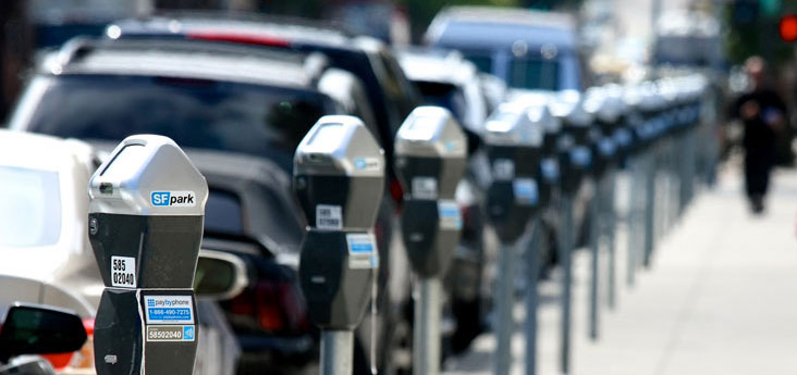
The SFpark Program

In 2011, San Francisco’s SFpark program started in several pilot neighborhoods around the City. The SFpark program includes many of the progressive parking reform ideas long championed by Livable City. Sensors in parking spaces on the street and in city-owned lots gather accurate information about how on-street parking is used, and how many spaces are available. The information gathered is used to adjust parking rates in response to demand, towards the goal of creating some available spaces at all times of day. Creating available spaces is a convenience to merchants and residents, and reduces traffic by eliminating cars cruising for parking spaces. The program has also installed ‘smart meters’ that make it easier for MTA to adjust rates up or down based on demand and to adjust time limits and hours of operation, and make it easier to pay for parking with credit cards, smart cards, and cash.

Adding new parking is costly, both in environmental and economic terms; SFpark will allow the city to much better manage existing parking for the benefit of residents and businesses.

SFpark’s pilot projects build on the findings of the San Francisco County Transportation Authority’s On-Street Parking Management and Pricing Study. The SFCTA study looked in depth at parking issues in four San Francisco neighborhoods – Cow Hollow, West Portal, Hayes Valley, and Bernal Heights. The study surveyed parking availability, parking turnover, and parking duration, and interviewed merchants and residents. Among the study’s findings were that both businesses and residents were willing to pay more for parking in return for greater availability, and that while merchants in the four neighborhoods thought that 72% of their customers “drove exclusively” to the neighborhood, over 70% of their customers walked, cycled, or took transit (The final SFCTA study can be viewed here).

In 2017, the SF Municipal Transportation Agency extended the SFpark program’s variable pricing citywide.

Neighborhood Transportation Plans

Livable City is working to get the Planning Department to create neighborhood transportation plans for transit-intensive neighborhooods, including Downtown and the City’s Better Neighborhoods and Eastern Neighborhoods planning areas. Our advocacy led to the Planning Department finding funding for a Mission District Transportation and Streetscape Plan.

Parking Benefit Districts

Livable City is working to enact a parking benefit district ordinance, like those in place in Pasadena, West Hollywood, Santa Monica, and other California cities. Parking benefit districts are a surcharge on local parking meter rates, agreed to by the community, of which half go to Muni and other citywide programs, and the other half stays in the community for local pedestrian, bicycle, streetscape, and maintenance programs. Livable City supported SFCTA/Planning Department study of parking benefit districts that should be complete by the end of the year.

Successes to Date

San Francisco first instituted parking requirements in 1955, when planners were busily trying to adapt cities to the needs of the automobile, rather than the other way around. (see A brief history of parking requirements in San Francisco)

The early 1960’s saw San Francisco’s “Freeway revolt”, and the 1970’s saw the rise of the environment movement, the opening of BART and San Francisco’s first “transit first” policy, and the first “traffic calming” efforts to take back San Francisco’s streets from the automobile. In the 1980’s, new thinking about parking began to take hold among progressive planners. San Francisco adopted the Downtown Plan in the mid-1980’s, which established strict limits on the amount of new office parking to discourage commuting by automobile.

The Mission Bay Redevelopment Plan, adopted in 1997, was the first area of the city to have no residential parking requirement. Livable City was founded in 2002, and made parking reform a centerpiece of our strategy for creating a more livable, affordable, sustainable, and vital San Francisco.

Livable City’s first decade saw great progress in parking reform. The City adopted the Rincon Hill plan in 2005, which became the first neighborhood to have no parking requirements for any use, the second neighborhood to eliminate minimum residential parking requirements, and the first to require unbunding, car share, and secure bicycle parking for new residential developments.

Livable City worked with Supervisors Peskin and Daly to pass the landmark downtown parking reform in 2006. This ordinance finally eliminated minimum parking requirements for housing in the downtown commercial (C-3) zoning districts, and set the first parking maximum below one space per unit It requires active, pedestrian-oriented uses on ground floors of buildings and limits driveway cuts and garage entrances on important pedestrian, bicycle, and transit streets in the downtown. The ordinance expanded residential unbundling to downtown, and expanded car-share and secure bicycle parking requirements citywide.

In 2006, Livable City published a research paper which identified the market for housing with reduced parking, to overcome financiers’ reticence to financing projects with reduced parking. We also helped eliminate minimum parking requirements for senior and affordable housing, allowing developers to build only the parking residents need, and not waste scarce funding on excess parking.

San Franciscans overwhelmingly rejected Measure H in November 2007, which would have increased the amount of office parking downtown, and imposed a uniform set of parking requirements on new buildings across the city. The defeat of Measure H upheld the city’s decades-old strategy of limiting commuter parking downtown, and preserved the right of neighborhoods to craft parking solutions that fit their needs and character.

2008 was a tipping point. San Francisco saw the biggest changes to on-street parking management and off-street parking requirements since 1955, when parking requirements were first imposed citywide. In April, the Board of Supervisors adopted the Market and Octavia Neighborhood Plan, which extended the progressive parking policies (trading minimums for maximums, unbundling, and driveway controls) from Downtown and Rincon Hill into the Hayes Valley, Duboce Triangle, and North Mission neighborhoods. In December, Board of Supervisors adopted the Eastern Neighborhoods plans, which propose eliminating parking requirements in portions of South of Market, the Mission, Showplace Square, and the Central Waterfront. The draft Western SoMa plan was released mid-2008, recommending eliminating or reducing parking requirements in the entire Western SoMa area.

Two citywide parking reform initiatives approved in 2008 improved the way we manage parking in the city, and helped to forge a new consensus on the role parking ought to play in a more livable San Francisco – the comprehensive parking reform ordinance of 2008, and MTA’s SFpark program. Livable City helped draft the comprehensive parking reform ordinance, which buildt on the success of 2006’s downtown parking reform. It included a number of commonsense reforms which “could please both sides on parking issues”(SF Examiner). The ordinance expanded “unbunding’ of parking (separating housing costs from parking costs) citywide, and allows developers to use space-efficient parking methods (valet parking, lifts, and stackers) without special permission. The ordinance also eliminated minimum parking requirements for senior housing, housing for people with disabilities, and housing dedicated to low-income residents.

Livable City continues working to remove minimum parking requirements in transit-rich areas of the city, including Chinatown and North Beach (2010), SoMa (2011), Glen Park (2012), Outer Mission Street (2013) Van Ness Avenue (2014), the northern Embarcadero (2014), Divisadero Street (2014) and Fillmore Street (2014). In 2018, Livable City led the successful effort to eliminate remaining parking requirements citywide.

In 2010, Livable City helped revise the Planning Code’s street frontage requirements, requiring new above-ground parking to be wrapped in street-fronting active uses, like housing or storefronts, limiting the width and location of garage entrances, and requiring that downtown parking structures be built for later conversion to other uses.

Livable City worked to exempt of new and existing accessory dwelling units from minimum parking requirements; existing ADUs without parking were legalized in 2013, and building new ADUs without parking was permitted citywide in 2016.

Great Transit for a Livable City

Livable City’s Great Transit campaign is working to create a seamlessly integrated public transit network for San Francisco and the region that is fast, reliable, sustainable, and fully accessible. Our transportation investments should move the city towards an environmentally sustainable future, as well as support community health and social equity. Our priorities are improving transportation options for individuals and families without cars, and increasing the number of people who will find it convenient to avoid the expense of car ownership.

SFMTA Muni's new light rail trains may look much like these.
SFMTA Muni’s new light rail trains may look much like these.

San Francisco’s Muni system is still stuck in a decades-old crisis of underinvestment and mismanagement of the overall transportation system. Despite a stable population in the city, Muni’s ridership is much lower than it was decades ago, and Muni proves consistently unable to meet the service standards mandated in the city charter. Our four-part strategy for turning Muni around includes:

  • Making Muni faster and more reliable by expanding the city’s public transit network, creating more dedicated transit lanesimproving the spacing of transit stops and lines, creating complete streets that include transit enhancements like transit lanes, transit signal prioritization, and bus bulbs, and converting to efficient and accessible low-floor buses and light rail vehicles.
  • Increasing funding for Muni through parking reform, including increasing the City’s parking tax, charging market rates at city-owned lots and garages, better management of on-street parking, and enacting appropriate impact fees for parking spaces in new developments.
  • Reduce traffic congestion by better land use planning, encouraging walking and cycling, reducing parking requirements in new development, smarter management of the city’s parking, and innovative strategies like congestion charging.
  • Plan livable, transit-friendly neighborhoods, which allow car-free housing near transit hubs, lower parking requirements near transit, mandate pedestrian-friendly building designs that enhance the safety and appearance of streets, calm traffic and creating complete streets that provide safe routes to transit, schools, shops, and services, and create great stations that provide efficient and accessible transit connections and great public spaces that serve as centers of community.

Current Campaigns

High Speed Rail is coming to San Francisco

In November 2008, Californians approved a $9.95 billion dollar general obligation bond, the down payment on a $40 billion project to create a 800 mile high speed rail system for the State of California.

The system being planned by the California High Speed Rail Authority will link the Bay Area to Sacramento, the Central Valley, and Southern California. Express trains from San Francisco will get to Los Angeles in 2 hours and 38 minutes.

Twenty-five High Speed rail stations across the state be located in existing town centers, and are planned as hubs for connecting transit and walkable, transit-oriented communities. The High Speed System will improve air quality and reduce greenhouse gas emissions, and save billions in airport and highway expansion costs.

The bond puts $9 billion towards the high speed system, which will allow the state to leverage federal matching funds. $990 million of the bond will be allocated to connecting rail services across the state, with over $100 million to Muni and $280 million to BART to expand capacity and improve service on lines that connect to High Speed Rail.

Using Caltrain ‘Regional Metro’ to Foster Livable Neighborhoods

Approval of the High Speed rail will also speed the transformation of Caltrain into a “regional metro”, with fast, frequent, electrified service between a downtown terminus at the Transbay Transit Center, connecting San Francisco’s downtown and its bayside neighborhoods to the Peninsula, Silicon Valley, and East Bay. San Francisco’s Downtown, SoMa, Mission Bay, Potrero Hill and Central Waterfront, Bayview and Visitacion Valley neighborhoods will enjoy BART-level electrified rapid transit service, as well as express and intercity services on a grade-separated right-of-way shared with high speed trains.

High Speed Rail and Caltrain modernization will be the this decade’s biggest transit investment in San Francisco. Let’s take the opportunity presented by this huge project to re-think the entire Caltrain Corridor and fully realize the potential benefits for San Francisco’s livability, sustainability, and prosperity.

  • Remove I-280 and put the rail line underground: Just as removal of the Embarcadero and Central Freeways increased the livability of the surrounding neighborhoods and freed acres of land for new homes, businesses, and open spaces, removing I-280 north of 101 could transform a wide swath of San Francisco for the better: reducing traffic, pollution and blight, freeing large tracts of land along the Caltrain line for new housing and offices, and knitting divided neighborhoods back together. Coupled with putting Caltrain and High Speed Rail underground through Potrero Hill, Mission Bay, and SoMa, removing I-280 will allow a new neighborhood to rise on the site of the Caltrain yards and elevated freeway. Currently, I-280 dumps traffic onto 6th Street, making this struggling street into one SoMa’s deadliest, and onto the Embarcadero, cutting the city off from its waterfront. Removing I-280 will reduce SoMa traffic by shifting trips from car to rail, making SoMa, which is one of the city’s fastest-growing residential neighborhoods, a better, safer, and healthier place to live, work, and play. Underground tracks and the removal of I-280 will allow Mission Bay to connect to the Showplace Square area, freeing several large blocks for housing, businesses, and open space, and allowing electrified 16th Street transit to extend into Mission Bay. Potrero Hill and the Central waterfront could be knitted together with restored grid of neighborhood streets and new housing.
  • 16th Street Station: A new regional metro station just south of 16th Street would connect to UCSF and Mission Bay to regional transit, and the planned 16th Street bus rapid transit line would connect numerous neighborhoods to Caltrain and BART.
  • Oakdale Station in Downtown Bayview: Building the long-planned Oakdale Station will foster the development of a vital and walkable ‘Downtown Bayview’ in the neighborhood’s existing commercial and cultural heart. Moving the SFPUC’s antiquated sewage digesters to the Pier 96 backlands, rather then replacing them on-site, allows the huge sewage digester site to become a new transit village just south of the Oakdale Station. A local bus and streetcar network, together with bike lanes and walkable streets, would radiate from the Oakdale station, connecting the adjacent neighborhoods, including the proposed Hunters Point Shipyard and Candlestick Developments, to regional transit.
  • Bayshore Station and Geneva Light Rail. A walkable neighborhood center is emerging in San Francisco’s Visitacion Valley, with the streetscape improvements in the Leland Avenue commercial district and the planning and toxic cleanup for the 22-acre Schlage Lock site on Bayshore Boulevard. Extending the 3rd Street light rail line out Geneva Avenue to Balboa Park Station could help transform the Geneva Avenue corridor, including Cow Palace, Sunnydale, and other industrial and motel sites, into a livable, transit-oriented neighborhood.

2012 Rapid Network

In 2003, San Francisco voters approved Proposition K, a renewal of San Francisco’s half-cent sales tax. The largest investment in Prop K was a citywide rapid network, which would improve the city’s light rail and bus lines by providing dedicated lanes and other transit-priority projects, as well as fund new light rail and bus rapid transit lines in important corridors. We are working to get plans for rapid transit lines or transit-preferential streets on the city’s most important corridors adopted, and a first phase completed, by 2012. Our vision includes modern low-floor light rail vehicles and buses, with doors on both sides that can accommodate both center-island and side boarding. Planning for these corridors should take a “great streets” approach, with beautiful and walkable streetscapes and continuous bicycle routes on the corridor or on a parallel corridor. Our 2012 corridors include:

  • Market Street: Market Street serves as the city’s symbolic “main street”, its chief public transit corridor, and its most important bicycle route, so getting Market Street right is essential to the livability of the city. Market Street’s transit operations need improvement, and its stations, stops, and boarding islands should be better places to wait. Many stretches of the street are uninviting to pedestrians, and the public spaces along the street are poorly designed and maintained. The bicycle lanes are discontinuous and poorly enforced. Livable City is working with the San Francisco Bicycle Coalition towards implementation of the modest transit, bicycle, and pedestrian improvements that came out of the Transportation Authority’s Market Street Study, and to build support for a more thorough redesign of the street.
  • Geary Boulevard: The Transportation Authority is currently studying bus rapid transit alternatives for Geary; we have asked the TA to develop light rail alternatives, and to better integrate bicycle and pedestrian improvements.
  • Van Ness – Mission: The Transportation Authority is currently studying Bus Rapid Transit in the Van Ness Corridor. Livable City wants to see a plan for phased transit-preferential street improvements or rapid transit on Mission Street from the Embarcadero to Daly City. A parallel bicycle corridor shoud be completed on Market, Polk, Valencia, San Jose, and Alemany.
  • Potrero-Bayshore-San Bruno-Geneva: Livable City was involved in planning the first-phase transit priority improvements on Potrero Avenue, and are advocating for a plan for the entire corridor from Market Street to the Balboa Park BART station, with a major intermodal hub at the Bayshore Caltrain Station connecting 3rd Street Light Rail, Caltrain, and Bus Rapid Transit.
  • 3rd Street – Kearny/Stockton – Columbus: Muni’s 3rd Street light rail line opened in April 2007. We would like to see the light rail extended through downtown and out Columbus Avenue, with a comprehensive study of surface, subway, and combined surface/subway options. The Central Subway proposal, however, falls short in a number of regards. Some of the questionable decisions made about the project were covered in an independent report commissioned by MTA.

MTA Budget

Livable City will is working with other sustainable transportation advocates to ensure that the 2006 MTA Budget is balanced without further fare increases, service cuts, or deferred maintenance, and that MTA’s pedestrian, bicycle, and accessibility programs are adequately funded. We will continue to promote cost-saving strategies, like transit-priority measures, as well as revenue sources like user fees on cars, to help balance the MTA budget.

  • Reduce Muni Operating Costs and Improve Service: transit-priority measures, like dedicated transit lanes, bus bulbs, and traffic signal prioritization, as well as improved route- and stop-spacing, can do much reduce Muni’s operating costs and improve Muni frequency, speed, and reliability. Livable City is on the advisory committee for the Transit Effectiveness Project, the City Controller’s study of improving Muni operations, and is working with SPUR, Rescue Muni, and other advocates to improve Muni operations and reduce costs.
  • Charge Fair Market Price for Public Parking: Public parking garages and lots throughout the city charge much less for parking than their private competitors, essentially using local tax dolllars to subsidize parking. Livable City is seeking a volunteer to review the rates of all public parking garages and propose increases to bring the rates in line with rates at private garages. Send an email to Tom Radulovich to volunteer.
  • Parking Benefit Districts: Livable City will work to enact a parking benefit district ordinance, like those in place in Pasadena, West Hollywood, Santa Monica, and other California cities. Parking benefit districts are a surcharge on local parking meter rates, agreed to by the community, of which half go to Muni and other citywide programs, and the other half stays in the community for local pedestrian, bicycle, streetscape, and maintenance programs. Livable City supported SFCTA/Planning Department study of parking benefit districts should be complete in the spring.
  • Parking Impact Fees: Livable City will work with the Planning Department to study a fee on new parking spaces in the downtown and elsewhere which mitigates the impact on pedestrian, bicycle, and transit movement created by the traffic they generate.
  • Congestion Charge: Livable City will work to advance the city’s study of a downtown congestion charge, like those in London, Stockholm, and Singapore.

Great Stations

Livable City’s Great Stations Initiative is dedicated to transforming San Francisco’s transit stations into world-class transit hubs that connect Muni to BART, Caltrain, ferries, and ultimately to high speed rail. Great stations have excellent pedestrian, bicycle, and local transit connections, full access for people with disabilities, and great station art, architecture, and amenities. Great stations should have great public spaces – plazas and streetscapes – nearby, and be surrounded by appropriate transit-oriented land uses.

Transportation Infrastructure Funding

Livable City will work to establish, and to get appointed to, a committee to look creating cost-effective, equitable, and sustainable funding for the long-term needs of the city for street resurfacing and infrastructure maintenance.

Past Successes

Muni Budget: In past years, Livable City worked with the Coalition for Transit Justice to develop and advance alternatives to Muni fare increases and service cuts. Based on Livable City’s list of innovative funding sources, MTA developed a number of budget alternatives, including one with no fare increases or service cuts. As a result of Livable City advocacy, the percentage of the Muni budget shortfall filled from Muni service cuts and fare increases dropped from the over 80% originally proposed to 56% in the budget ultimately adopted by the commission in 2005/6.

Reauthorizing and Reprogramming of the 1/2-cent SF Sales Tax: Between $2.35 and $2.82 billion will be generated by San Francisco consumers over the next 30 years. Livable City has succeeded in making sure we are getting our money’s worth from these revenues: the measure directs more money than ever into pedestrian and bicycle safety; the relies heavily on cost-effective, network-based transit improvements; it links land use to transportation. For details on Livable City’s campaign about the sales tax, click here.

At 40 Years, San Francisco’s Transit-First Policy Still Struggles for Traction

With Smarter Land Use, SFCTA Could Avert “Total Gridlock”

sf-traffic

Complete Streets Initiative

Livable City is working to ensure that city streets, which cover over 25% of San Francisco’s land area, are designed and maintained as a safe and attractive public spaces that support walking, bicycling, and public transit.

Our current efforts are to improve the City’s designs and standards to improve the appearance, safety and accessibility of city streets, protect neighborhoods from excessive traffic, and remove dangerous conditions for bicylists and pedestrians. Livable City supports streetscapes that integrate street trees and landscaping, energy- and resource-efficiency standards, and that minimize impermeable pavements to improve the livability of the city while reducing environmental impacts and infrastructure costs.

better-street-noe

Livable City’s complete streets campaign works at three scales: citywide reform, neighborhood planning, and individual projects. We are working citywide to improve streets standards, improve the effectiveness, responsiveness, and coordination of city departments, and increase funding opportunities for complete streets projects. At the neighborhood scale, we are working to empower every neighborhood to create its own complete streets plan, and to secure the funding and bureaucratic support to implement neighborhood plans that have already been completed. We are also engaged in innovative projects all over the city to create complete streets, and that demonstrate what is possible.

Livable City has been participating in the City’s Better Streets Plan. We submitted extensive comments and recommendations on the Better Streets Plan Draft for Public Review in December 2008. A revised Better Streets Plan, as well as a Better Streets Institutional Analysis prepared by the Controller’s Office, were completed and adopted in 2010.

 Our Current Projects

  • Two-way Haight Street. Livable City supports the SFMTA’s proposal for restoring two-way traffic to the first block of Haight Street. This will allow the Muni 6 and 71 routes to run in both directions on Haight, which will improve speed and reliability for over 20,000 daily riders. The project includes pedestrian safety improvements at the Haight-Gough-Market intersection, one of the most dangerous in the City.
  • Folsom, Howard, 7th, and 8th Streets. Livable City helped draft the Western SoMa Plan, which called for transforming Folsom and Howard Streets into neighborhood-serving streets, with two-way transit on Folsom, wider sidewalks, and cycling improvements. The plan called for restored two-way traffic and other improvements on 7th and 8th Streets, including completing a two-way bicycle connection along 7th from Market to 16th Streets.
  • Ellis and Eddy Streets. The Tenderloin/Little Saigon Transportation Plan called for several one-way to two-way conversions in the Tenderloin, including McAllister, Eddy, Ellis, Jones, and Leavenworth. McAllister is complete, and Ellis and Eddy are under discussion as a mitigation for the massive CPMC hospital proposed at Geary and Van Ness.
  • Ocean, Geneva, and San Jose Avenues. The streets surrounding Balboa Park Station are dangerous for pedestrians and cyclists. SFMTA has identified some near term in their Balboa Park Area Pedestrian and Bicycle Connection project, including new crosswalks and signals, pedestrian safety improvements, bicycle improvements, and safety improvements to nearby freeway ramps, and secured funding for crosswalk improvements where Geneva meets I-280, and for a new crosswalk where BART’s new Ocean Avenue Entrance meets Ocean Avenue. Livable City is advocating for fixes to the dangerous freeway ramps on Ocean and Geneva Avenues, and lighting, cycing, and walking improvements on the streets surrounding the station.
  • Eastern Waterfront – The Embarcadero, Terry Francois, and Cargo Way. Livable City supported the 2009 Parks Bond, which is funding a set of modest improvements to the Blue Greenway from China Basin to Hunters Point. Livable City is also advocating for dedicated cycle paths along the Bay Trail, including Marina Boulevard, The Embarcadero, Terry Francois Boulevard, and Cargo Way.
  • Cesar Chavez Street. Livable City has been working to complete pedestrian and cycling connections between the Waterfront, Bayview, and Mission neighborhoods through The Hairball as part of the Planning Department’s Cesar Chavez Street East Plan.
  • Building Standards. Livable City worked with Supervisor Ross Mirkarimi to overhaul the Planning Code’s standards for building fronts, to encourage or require pedestrian-oriented street-fronting building frontages, limit driveway widths and locations to preserve and enhance pedestrian safety and amenity, and permit exceptions from off-street parking requirements to protect historic buidings, landmark trees, and important walking and cycling streets.
  • Street, Block, and Open Space standards. Livable City has developed and proposed Planning Code standards and incentives for creating pedestrian-oriented streets, small blocks, and public open spaces in large developments.

Our Citywide Strategy

Livable City’s citywide strategy for complete streets is integrated with and complements our land use vision (City of Neighborhoods), our strategy for an effective and seamless transit network, and our campaign for a citywide Greenway Network.

The citywide strategy has ten elements.

  • Reclaiming the Central City
  • Great Streets Network
  • Neighborhood Centers
  • Home Zones
  • Green Network
  • strategy and priorities
  • improve standards and metrics
  • improve planning and public participation
  • create stable funding and improve project coordination
  • improve maintenance and enforcement

Reclaiming the Central City

Downtown and the surrounding neighborhoods – SoMa, Tenderloin, and Chinatown – are San Francisco’s densest neighborhoods, residents of these neighborhoods have the City’s highest rates of transit use, walking, and cycling.

Unfortunately, these neighborhoods, which contribute least to traffic and environmental impacts, are subjected to unhealthy and unsafe levels of traffic and traffic-related noise and pollution, these neighborhoods often lack nearby green and well-designed parks, sidewalks, and plazas.

Livable City’s strategy for reclaiming the central city includes:

  • street reclaiming; one-way to two-way street conversion, widen sidewalks where needed, complete the bicycle network, especially north of Market.
  • get transit moving: transit-priority measures, improved conections, accessible transit, proof-of-payment.
  • create great plazas and parks: improve existing plazas and parks, reclaim streets and parking lots for public spaces.
  • alleyways: revitalize and pedestrianize alleyways, preserve and extend alleyway networks.
  • pedestrian-friendly buildings (pay attention to street level; restore historic buildings, form-based controls for new buildings, encourage the retrofit of modernist buildings to make them pedestrian-friendly.

Downtown: see Livable City’s Livable Downtown page for details.

Chinatown: Livable City supports reclaiming Chinatown’s Alleyways, improving Grant Avenue as a pedestrian-oriented street, and improving public transit and pedestrian safety on Stockton and Kearny streets, and making Washington and Clay streets more bicycle and pedestrian-friendly.

Tenderloin: see our Tenderloin page for details.

Civic Center: San Francisco’s Civic Center is rich in history and distinguished architecture, but its streets and public spaces are badly designed and dominated by traffic. Livable City supports pedestrianizing Fulton Street between Larkin and Hyde, narrowing the excessively-wide sections of Polk, Grove, Larkin, and McAllister streets that isolate City Hall and Civic Center Plaza, and improving Grove Street for cycling and walking, and McAllister for walking, cycling, and transit.

South of Market: The South of Market neighborhoods are made up of large blocks which are divided by a series of intimate alleyways. Livable City is working to green and calm SoMa’s wonderful residentiall alleyways, and extend the alleyway network where it s lacking. We are working to implement the street improvements and green open spaces called for in the Transbay and Rincon Hill Plans, and convert Folsom, Howard, 7th, and 8th from harsh, fast-moving, one way streets to slower, greener two-way streets that put pedestrians, cyclists, and transit first.

Removing the Central Freeway: Extending Octavia Boulevard into South of Market to replace the aging Central Freeway would help revitalize the neighborhood. Removing the freeway would reconnect the Mission and SoMa neighborhoods, reclaim land for housing and other uses, and reduce blight and improve safety. The freeway is almost 60 years old, and the roadway is nearing the end of its useful life. The Transportation Authority should study alternatives to a simple rebuilding of the overhead structure, so that we we have a better alternative ready when the freeway needs replacement.

Great Transit Streets

Livable City is working to make sure that the dozen or so corridors that comprise the city’s rapid transit network, focus both on improving transit speed, reliability, and accessibility, and on creating great streets that integrate pedestrian, bicycle, and streetscape elements with light rail and rapid bus projects.

  • Market Street
  • Mission Street
  • Geary Street – Geary Boulevard
  • Van Ness Avenue
  • Columbus Avenue: The San Francisco County Transportation Authority is working a Columbus Avenue NeighborhoodTransportation Study along with RenewSF, a coalition of neighbors and businesses dedicated to improving San Francisco’s Columbus Avenue. Livable City has provided technical and policy support, and helped publicize RenewSF events.
  • N-Judah (Duboce, Carl, Irving, Judah)
  • 3rd Street
  • West Portal Avenue
  • 19th Avenue
  • Ocean Avenue
  • The Embarcadero
  • Potero Avenue – Bayshore Boulevard – San Bruno Avenue
  • Haight Street
  • McAllister and Fulton streets

Neighborhood Centers

San Francisco is a city of neighborhoods, and vibrant, walkable neighborhood centers make San Francisco more livable and sustainable.

  • Public Spaces: create or restore a great public space in the heart of each neighborhood. These include:
      • Castro: Harvey Milk Plaza
      • Mission: BART station plazas
      • North Beach: Washington Square, Piazza San Francisco (Vallejo Street between Grant and Columbus)
      • Glen Park: BART plaza
      • Balboa Park: new plazas at the Geneva and Ocean entrances to the BART station, Phelan Loop park
      • Excelsior: Persia Triangle Park
      • Crocker/Amazon: Naples/Geneva plaza
      • Hayes Valley: Patricia’s Green
      • Noe Valley: 24th and Castro
      • Fisherman’s Wharf: Jefferson Street, Waterfront Park, Joseph Conrad Square
  • Walkable Commercial Streets
      • Castro Street (Market to 19th)
      • Divisadero Street: The Department of Public Works (DPW) secured $3 million in Federal funding for greening and streetscaping Divisadero. DPW and MTA will present their findings and a block-by-block proposal for greening, streetscaping, and potential traffic and transit changes. See DPW’s project page for more information.
      • Hayes Street: Livable City has been working with neighbors and businesses to restore two-way traffic on Hayes. See our Market & Octavia page for more information.
      • Leland Avenue: Livable City is participating in the community-driven effort make Leland Avenue, the main commercial street in San Francisco’s Visitacion Valley neighborhood, into a complete street.
      • Valencia Street: The Better Valencia Project is a neighborhood effort dedicated to making San Francisco’s Valencia Street a complete street. Livable City is actively involved in this neighborhood coalition.
  • Planning Controls and Pedestrian-friendly Building Design
  • Parking Management

Home Zones

Home zones are residential streets that are designed around pedestrians and cyclists, and limit traffic to low speeds. Home zones are designed to allow everyone, including children and seniors, to move safely on foot and on bike.

San Francisco’s General Plan has a decades-old policy that designates most of the city’s residential neighborhoods as “protected residential areas”, yet has never prioritized making these home zones a reality. Livable City is working to create a process and standards for creating home zones, and getting the city to commit staff and resources to implementing them.

  • traffic calmed zones
  • residential alleyways
  • residential boulevards: calm traffic and improve walking and cycling on the city’s residential boulevards, including
    • San Jose Avenue and Guerrero StreetSan Jose/Guerrero Coalition to Save Our Streets is a coalition dedicated to improving the San Jose/Guerrero Neighborhood. Livable City serves as fiscal sponsor to the coalition.
    • Oak and Fell streets
    • Dolores Street
    • Cesar Chavez Street
    • Octavia Boulevard
    • Monterey Boulevard (road diet and bike lanes)
    • Junipero Serra Boulevard
    • Sunset Boulevard
    • Alemany Boulevard
  • residential parking management
  • pedestrian-friendly buildng designs

Green Network

  • Bay trail
    • Cargo Way Streetscape Project: Cargo Way is an industrial street in Hunters Point that serves as part of the Bay Trail and the city’s Blue Greenway, as well as supporting the industrial and maritime uses in the area. Livable City was part of a team working for the Redevelopment Agency and Port of San Francisco to develop a plan for a greener, more bicycle- and pedestrian-friendly street. The Cargo Way Plan is now complete; see the Redevelopment Agency’s India Basin Industrial Park web page for further information, or contact Kelley Kahn to get on the Cargo Way email list: [email protected].
    • Embarcadero: Livable City is working to widen sidewalks along the Embarcadero, add a bi-directional bicycle path on the water side, improve pedestrian crossings of the Embarcadero, reduce parking over the water, and increase the speed, reliabilty, capacity, and accessibility of waterfront transit. Livable City serves on the Port’s Embarcadero Task Force.
  • coast trail
  • peaks
  • creeks

Strategy and Priorities

Better Streets Plan

In 2006, Livable City led a coalition of transportation and public space advocates to insist that the city develop an integrated, multi-modal, multi-objective, and multi-agency approach to designing and planning San Francisco’s streets. The result is the Better Streets Plan, a merger of sorts between the Planning Department’s Streetscape Master Plan and the MTA’s Pedestrian Master Plan.

In September 2007, The Planning Department held two public meetings to present their draft street types. The street types are meant to be the template for future street improvements. Each street type has a set of basic improvements that will, hopefully, be standard elements on all streets of that type, as well as a menu of additional options that could be applied to individual streets. The Planning Department released a Draft for Public Review in 2008. We submitted extensive comments and recommendations on the draft in December 2008. The Better Streets Plan was adopted in December 2010.

Citywide streets assessment

Livable City will work to secure funding for a citywide assessment of existing street conditions, and where they fall short of complete streets standards. This assessment can form the basis of a complete streets action plan to guide future years’ capital plans.

Improve Standards and Metrics

Complete Streets Standards

Livable City will work to advance the inter-departmental effort to create a comprehensive set of complete streets standards. These standards should address all transportation modes and street types, and include environmental and aesthetic standards. The city’s standards should include both minimum (least acceptable) and optimum (best possible) values.

Improve Planning and Public Participation

Neighborhood transportation plans

Livable City will work with the Planning Department to get the Mission Streetscape and Transportation Plan underway, Secure funding for a comprehensive Downtown and SoMa Transportation and Streetscape Plan, and to fund complete streets plans for other neighborhoods.

Create Stable Funding and Improve Project Coordination

Address San Francisco’s systemic street capital shortfall

Livable City is working to create a blue-ribbon committee, composed of representatives of users of the transportation system (pedestrians, transit riders, bicyclists, people with disabilities, etc), as well as neighborhood, civic, environmental, and urban greening and beautification groups and city staff, to recommend solutions to the city’s long-term capital funding shortfalls in the aftermath of the failure of Prop. B at the ballot box last fall. The committee’s recommendations should complete streets thinking into an approach to these infrastructure deficits that is equitable and both financially and ecologically sustainable.

Improve Maintenance and Enforcement

  • Improve government organization to improve street maintenance and accountability
  • increase funding for maintainance to keep streetscape in a state of good repair
  • automobile user fees that reflect true costs
  • sort out maintenance ‘gray areas’: sidewalks, street trees, street lighting, unaccepted streets, etc.
  • consistent enforcement of transit, bike, and ped access/safety

Complete Streets Ideas and Resources

“Intersection Repair” by Street Films 10 minute film, available online at the Street Films web site

City Repair in Portland, Oregon hosts an annual Village Building Convergence where hundreds of people come together to build diverse projects for the benefit of their communities and to take back their streets via a process known as the Intersection Repair.

Intersection Repair involves painting streets with a high-visiblity mural that creates a public square for residents to gather and one which gently encourages drivers to slow down when approaching these spaces. Over time the neighbors further enhance the transformation by adding amenities like benches, community bulletin boards, and introducing gardens & art. As you’ll see, the possibilities are endless.

Intersection Repair is the latest film by the amazing Clarence Eckerson for Street Films, which has created dozens of short films about making more livable cities.

The Case for Physically Separated Bike Lanes

The amazing Clarence Eckerson of the Open Planning Project has created another short film, The Case for Physically Separated Bike Lanes, posted on New York’s addictive (for us, anyhow) Streetsblog.

physically-separated-bike-lanes

The film makes the case for physically separating bicycle lanes from traffic on New York’s busy streets, where bike lanes are plagued with the same problems we have in San Francisco: intrusions by double parked and right-turning cars, with the same lax enforcement by the transportation department. The film features interviews with New York City cyclists and advocates, as well as Livable City heroes like former Bogota Mayor Enrique Penalosa, Danish urbanist Jan Gehl, and former New York City Deputy Transportation Commissioner “Gridlock Sam” Schwartz (would that we had traffic engineers like Gridlock Sam…)

Share or Segregate?

Are segregated bike lanes appropriate for every bike route? Possibly not. The detractors of separated lanes cite possible difficulties at intersections, where bicycles need to merge with right-turning traffic.

Another idea is that of shared space; creating narrow streets where cars move at slow speeds, and share the right-of-way with pedestrians and bicycles. The Dutch woonerf is one sort of shared street.

The video flashes an image from Transport for London’s excellent Cycling Design Standards (image to the right). London’s approach is to create segregated lanes on streets with high traffic volumes and speeds, but to calm lower-traffic streets to create shared spaces.

Lessons From New York: The Hudson River Greenway

The Hudson River Greenway, with its separated bicycle path and pedestrian promenade along the water’s edge, is featured prominently in the film. The path attracts 5000 cyclists on an average day, and feels usable and safe for both experienced cyclists and inexperienced ones.

Last year, Clarence produced a 12-minute film called Lessons from San Francisco: The Embarcadero Freeway Removal. The film features Livable City’s Tom Radulovich, the San Francisco Bicycle Coalition‘s Andy Thornley, and historian and activist Chris Carlsson, talking about the Embarcadero and Octavia Boulevard.

The Hudson River Greenway, with its bicycle and pedestrian paths and green piers, is a great model for San Francisco’s Embarcadero. While the Hudson River Greenway could have benefitted from a waterfront streetcar line like the Embarcadero’s F line, San Francisco would do well to create a separated bicycle path on the bay side of the Embarcadero like New York’s.

Ongoing Planning Efforts

Market Street: Livable City is participating in the City’s Better Market Street planning study. We are advocating for a car-free Market Street that is a great street for walking, cycling, and public transit, with  better lighting, signage, and wayfinding, and great public open spaces at Hallidie Plaza and United Nations Plaza. We are also working to improve Mid-Market

24th Street BART Plazas: BART hosted a community design workshop on Thursday, June 15 to help shape the future of the plazas at the 24th Street BART Station. The meeting revisited the 2001 for the 24th Street plazas, reviewing lessons learned from the 16th Street improvements, and prioritizing the first improvements for 24th Street Station. BART’s plans for the plazas and station can be found here. A grant application for a first phase of improvements was submitted based on the input from the workshop.

Architectural rendering of the Southeast Plaza at the 24th & Mission BART station. Renovation & construction of the plaza is due to finish in early 2014.
Architectural rendering of the Southeast Plaza at the 24th & Mission BART station. Renovation & construction of the plaza is due to finish in early 2014. Find out more about the project.

Mission Street (from Cesar Chavez to Randall) Transportation and Pedestrian Safety Workshop: Bernal Heights Neighborhood Center hosted a public workshop on transportation and Pedestrian safety on Saturday, July 15 as part of the Transportation Authority’s Mission Street Community Vision project. The meeting will be held at the Bernal Gateway Apartments, 3101 Mission Street at Cesar Chavez. Visit the study website for more information.

Balboa Park Station Area: The Balboa Park Station Area Plan, created several years ago by the planning department, envisioned a revitalized and reconnected neighborhood centered on Balboa Park Station, where BART, Muni Metro, and Muni bus lines converge. The Planning department held a “check-in” meeting on July 24th to discuss the new public plaza at the Phelan Loop, near Phelan and Ocean; a residential and retail project on the Kragen Auto site on Ocean Avenue; an update on the Muni-led effort to redesign the Balboa Park BART/Muni station, and a review of new zoning, parking regulations, and design guidelines. Visit the plan website for more details.

Past Successes

Livable City worked hard to make 2006 the year of the Complete Street. Our goal is that, starting in the 2006-2007 budget year, that every street project in San Francisco is a complete streets project.

  • Complete Streets Ordinance: In 2005, Livable City worked with Supervisor Ross Mirkarimi on a resolution in support of complete streets. later that year, Supervisor Ross Mirkarimi authored the Complete Streets Ordinance [PDF version], which requires that street resurfacing projects be coordinated with bicycle, pedestrian, and transit improvements and upgrades. It gave city departments a year to develop a plan for implementing the ordinance, including development of new standards that address pedestrian, bicycle, and transit access and safety, as well as street lighting, landscaping, and street trees.
  • Better Streets Ordinance: Livable City organized in support of the Supervisor McGoldrick’s Better Streets Ordinance, which was adopted in February 2006. [PDF version] Together with Walk San Francisco and the San Francisco Bicycle Coalition, Livable City worked with Supervisor McGoldrick to include provisions that expand public participation, ensure that faster and more complete implementation.
  • Streetscape Master Plan and Pedestrian Master Plan: Livable City led a coalition of advocates to integrate the Planning Department’s Streetscape Master Plan (SMP) with the Municipal Transportation Agency’s Pedestrian Master Plan (PMP) into a multi-modal, multi-objective, multi-agency plan that will, as Planning Director Dean Macris said, “Reinvent the way San Francisco thinks about its streets”. Thanks to our coalition’s efforts, the new integrated planning process will be overseen by the Director’s Working Group, a roundtable of the City’s transportation department heads.
  • Valencia Street: Livable City, as part of the Better Valencia Project, worked with neighbors, transportation advocates, and city agencies to develop a complete streets plan for Valencia Street, which will transform the street into a great walking and bicycling street. In June, the Department of Public Works team presented a design include much wider sidewalks, pedestrian bulb outs at the corners, a wider bike lane and parking lane, and landscaping, lighting, and street trees. (click here for the City’s presentation). Livable City worked to secure funding for streetscape improvements between 15th and 19th streets, which were completed in 2010.
  • Support neighborhood-based complete streets projects: In 2006, Livable City supported community-based planning efforts on San Jose and Guerrero streets, Cesar Chavez, Valencia Street, Columbus Avenue, Leland Avenue, and other streets.
  • Mint Plaza: Livable City helped secure official approval for Mint Plaza, a 250-foot long block of Jessie Street beside the Old Mint at 5th and Mission Streets that was transformed from a rutted alleyway into new pedestrian plaza. The project is sponsored by the Martin Building Company, and was funded will be built through an innovative public-private partnership. It is the first of what we hope will be many transformations of downtown streets into vital public spaces as envisioned in Livable City’s Livable Downtown Initiative.

Get in Touch

Staff Directory

Darin Ow-Wing, Executive Director
[email protected]

Jessica Tovar, Program Director
[email protected]

Sally Chen, Deputy Director
[email protected]

Tom Radulovich, Senior Policy Fellow
[email protected]

Isaac Santiago, Sunday Streets Program Manager [email protected]

Reina Terry, Program & Development Associate, reina@livablecity.org