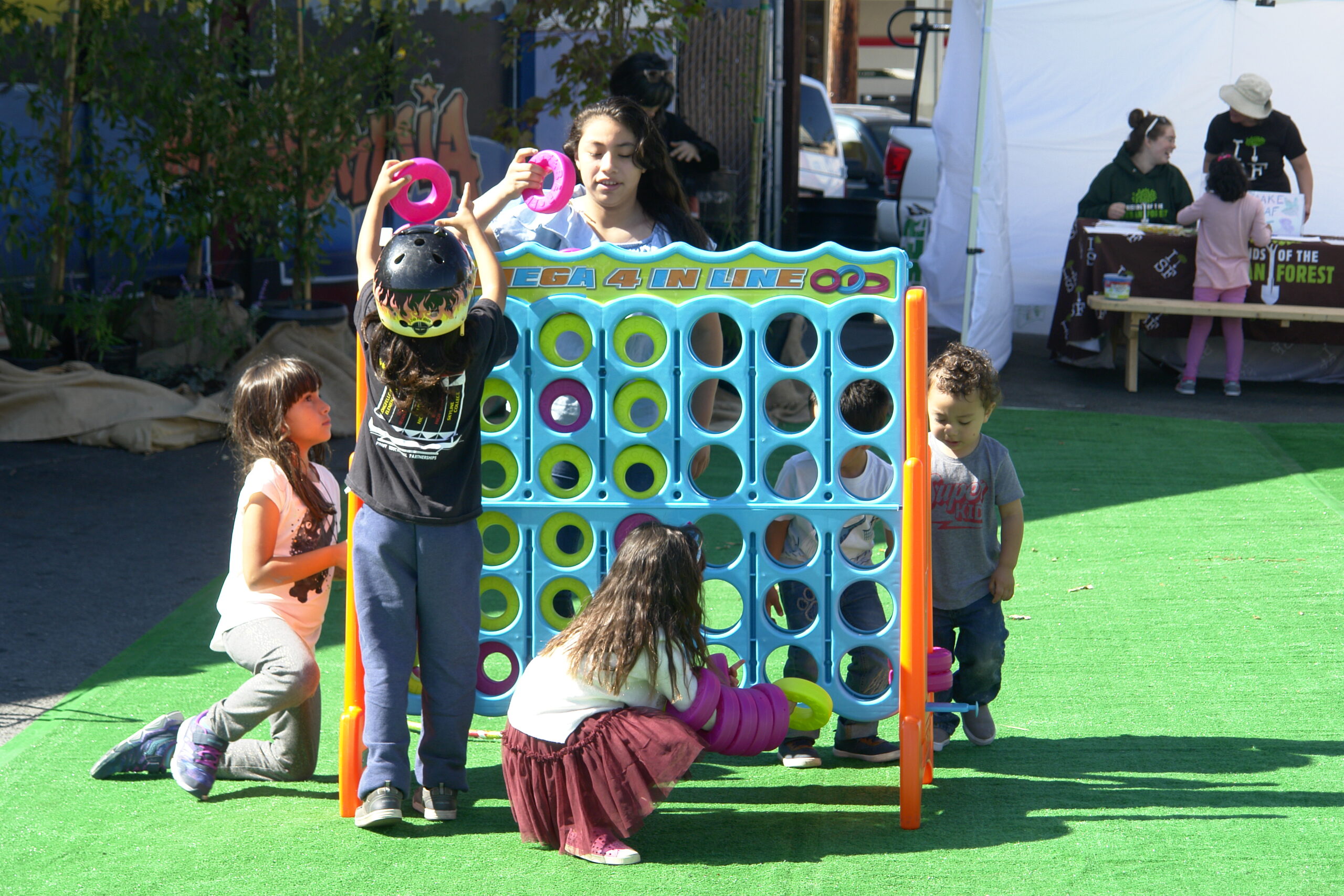
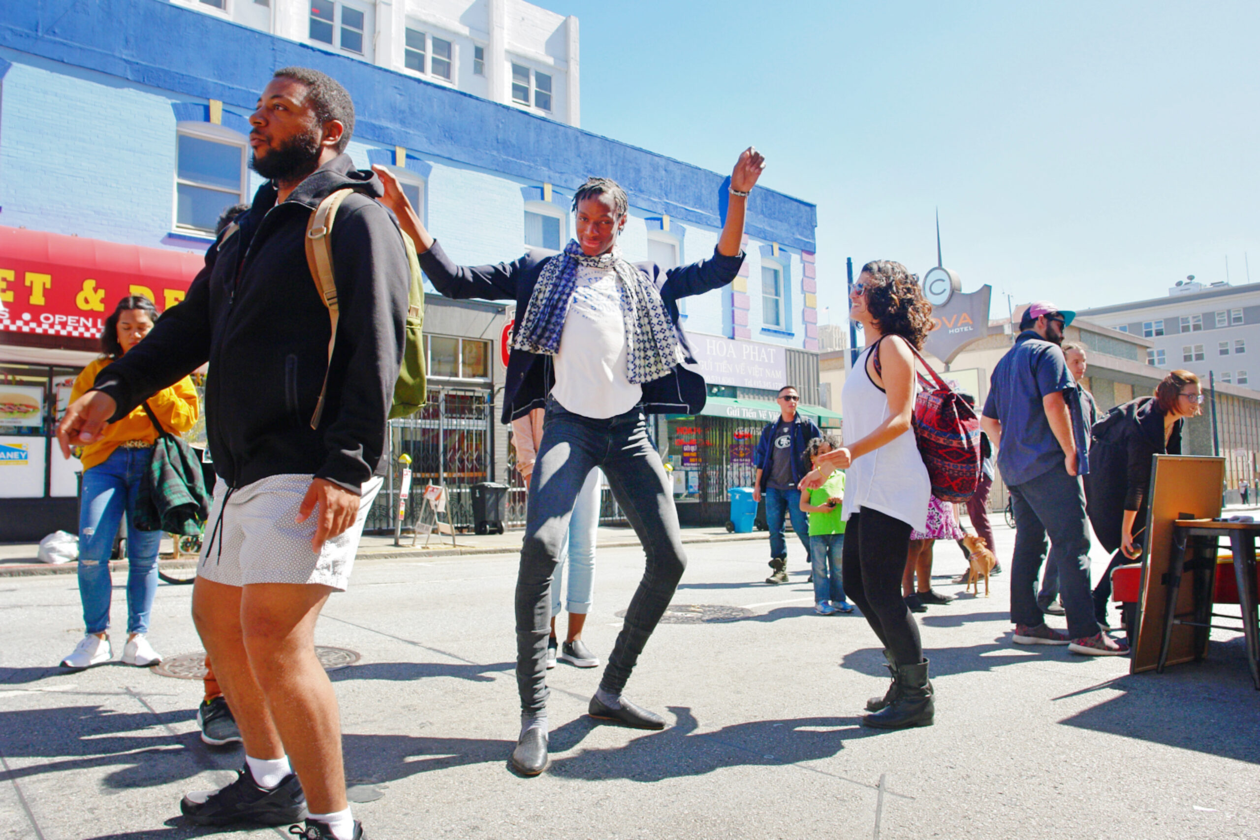
San Francisco –For the first time, a free Livability Summit will take place during Sunday Streets Mission on July 14, giving guests a chance to experience thought-provoking discussions on transit, mobility and public health, see the car-free event from the inside-out, and enjoy 1+ mile of open streets, all in the same day! Sunday Streets transforms the Valencia corridor from 26th Street to Duboce into a temporary park from 11 a.m. to 4 p.m.
The
Livability Summit and Awards Brunch will take place right in the middle of the
route at the Chapel on 777 Valencia St. At 12:15, the event transitions into a
speaking program open to the public, encouraging the greater Sunday Streets
community to learn, think, discuss and dream big about how transportation,
housing and public health solutions can become more equitable and sustainable
for everyone.
Support
Livable City’s important work, including
Sunday Streets, by purchasing the VIP Experience or RSVP to the public program,
featuring talks on Dreaming Big On Shared Mobility, Lightning Talk
Presentations from the Awardees and keynote conversation At The Intersection of
Transit and Public Health.
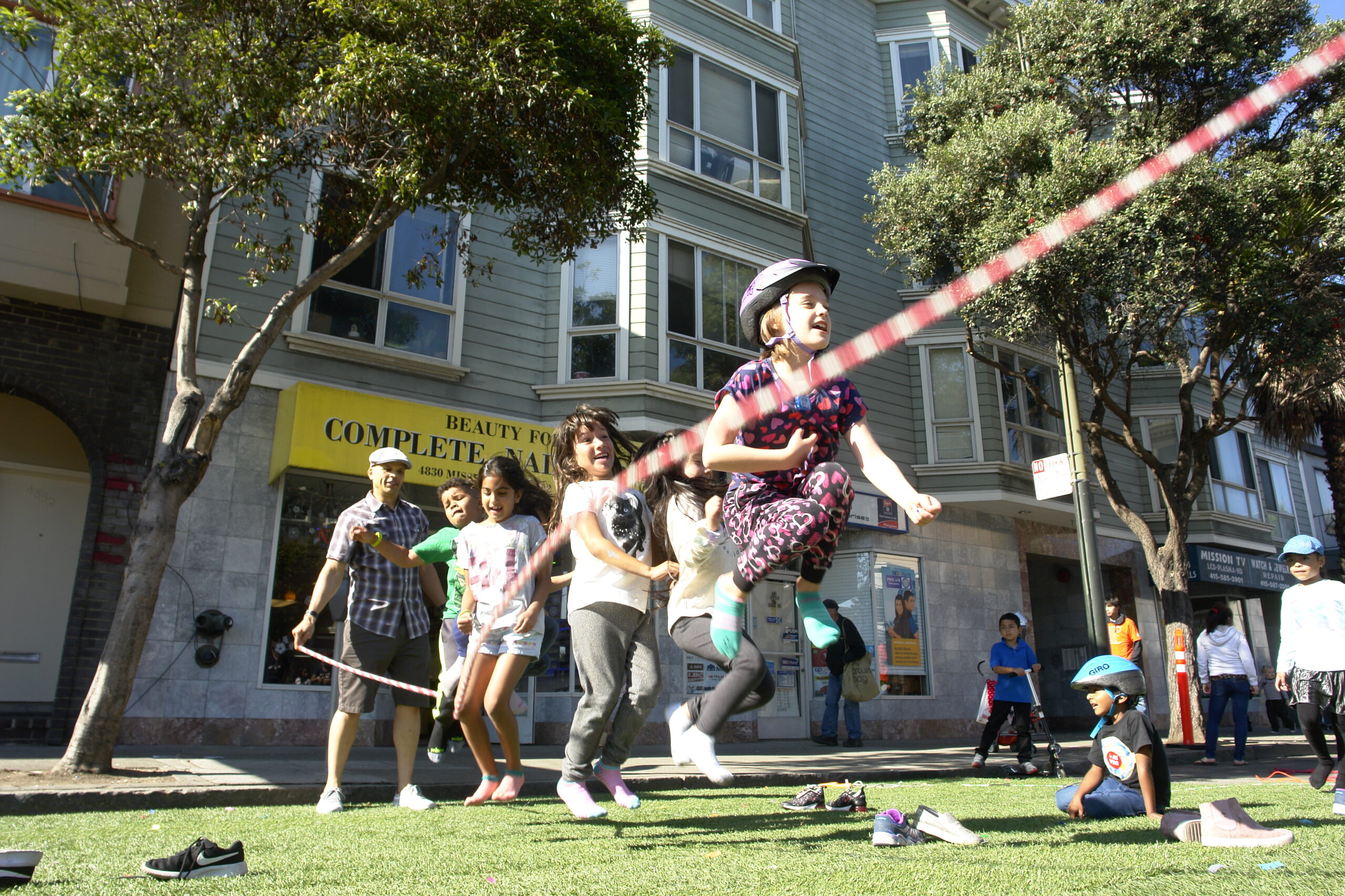
Out in the
streets, cultural performances, health resources, live music and over a mile of
open space provide free opportunities for all. In partnership with Mission Housing
Development Corporation, a pop-up Play Streets in front of the Valencia Gardens
complex brings a dedicated block of free activities, games and music for
children, residents and neighbors to enjoy and re-envision their streets as
accessible, public spaces.
Inspired by the Ciclovía
in Bogotá, Colombia, Sunday Streets is a series of free, fun events empowering
local communities to transform one to four miles of car-congested streets into
car-free community spaces for kids to play, seniors to stroll, organizations to
connect and neighbors to meet.
Nonprofit Livable City
runs both Sunday Streets and Play Streets, a program empowering neighbors to transform
their block into an accessible, car-free open space on a regular basis for
children, seniors, and neighbors to enjoy. Both programs are sponsored by
the SFMTA and other City agencies, and Sunday Streets would not be
possible without crucial services like Muni bus re-routing or traffic
control officers for public safety.
Project experts from
SFMTA and Vision Zero will be on hand throughout the season, providing neighborhood
residents and visitors direct access to transit planners and ambassadors
dedicated to sustainable streets.
Small businesses, residents, nonprofits and local
groups bring activities, volunteers and performances to the car-free routes,
with each contributing a distinctive character and energy to the day. A local
hire program employs San Francisco residents for outreach and event-day
support.
Transforming miles of car-dominated City streets
into open space is possible through the collaboration and hard work of hundreds
of volunteers, neighbors, nonprofits and small businesses. Donate, exhibit,
volunteer or sponsor Sunday Streets in 2019 to be part of a sustainable, greener
and more accessible future. For more information, visit www.SundayStreetsSF.com.
Sunday Streets
2019 Season Schedule
March 10 – Mission 1
March 31 – Excelsior 1
April 14 – Tenderloin 1
May 5 – Bayview/Dogpatch
June 9 – Sunset/GGP
July 14 – Mission 2
August 18 – SoMa
September 8 – Tenderloin 2
September 22 – Western
Addition
October 20 – Excelsior 2
The Sunday Streets 2019 season is made possible by the
following season sponsors: Bay Area Air Quality Management District
(BAAQMD), San Francisco Department of Children, Youth & Their Families
(DCYF), Mission Housing Development Corporation, San Francisco Department of
Public Works (SFPUC), Genentech, Office of Economic and Workforce Development
(OEWD), Sutter/CPMC, Golden State Warriors, iHeartMedia, Skip, Sutter/CPMC, Xfinity/Comcast
and Bi-Rite
About Sunday Streets
Sunday Streets is a program of the nonprofit
Livable City, presented in partnership with the San Francisco Municipal Transportation
Agency and the San Francisco Department of Public Health and the Shape Up SF
Coalition. Additional City support comes from the Department of Public Works,
Recreation & Parks Department, SF Police Department, SF County
Transportation Authority, San Francisco Mayor London Breed and her offices and
the SF Board of Supervisors.
About Livable City
Livable City is dedicated to increasing
affordable housing, improving transportation, land use, open space, and
environmental policies, and supporting grassroots initiatives to make San
Francisco a safer, healthier, and more accessible city. For more information on
Livable City, visit:https://livablecity.org. For more
information about Sunday Streets, including the Sunday Streets event activity
guide, visit: www.SundayStreetsSF.com. For information on Muni routes and
vehicle access, call 511 or go towww.sfgov.org/311.
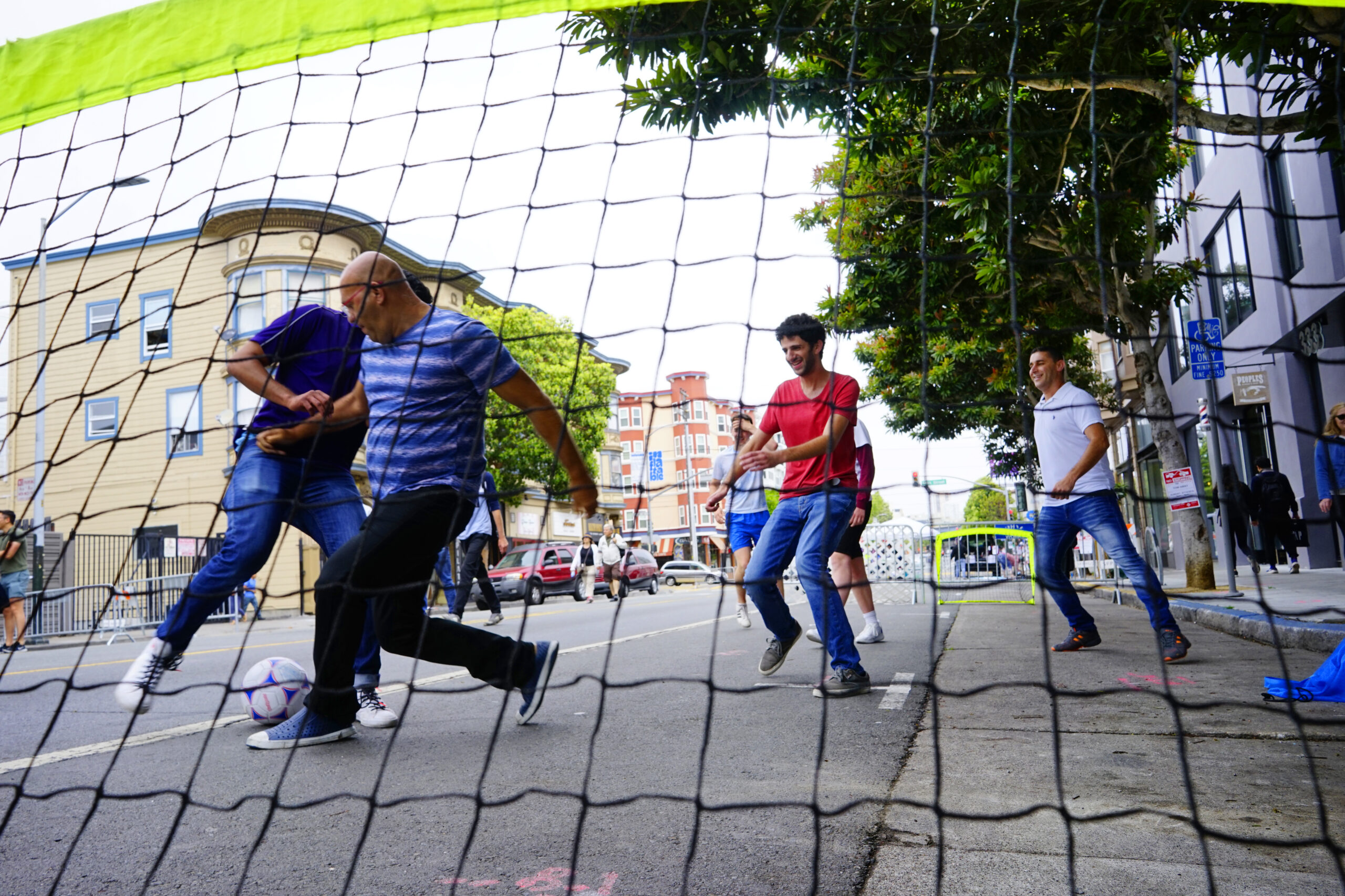
Small businesses bring programming to Sunday Streets. Photo by Young Chau
By Marynoel Strope
Last month, the Mission’s Borderlands Cafe announced their impending closure. Though there are plenty of coffee shops nearby, the loss of the business struck a chord with the community.
“We’re kind of a cafe designed for Valencia Street in 2010, not Valencia Street in 2020,” owner Alan Beatts told Mission Local of the spot, the type of coffee shop that specializes not in high-end pour-overs or artisanal snacks, but a comfortable, welcoming atmosphere
Customers who mourn the loss of a small business like Borderlands aren’t just going to miss what what the business sells, but the place itself. Local spots can serve as gathering places, as social outlets, as places to get advice and learn – both about the products and the goings-on of the neighborhood.
“It’s a well-lit place with tables where you can work, talk to friends, and play board games while enjoying coffee and a bagel,” Beatts said.
They don’t have to be businesses – they can be houses of worship, community centers, libraries or public parks. They’re wherever people, meet, socialize, and spend time together, are accessible and either low-cost or free.
The Third Place
“Third places” occupy a unique, critical space, existing separately from the home (the “first place”) and the workplace (the “second place”). The term was coined by urban sociologist Ray Oldenburg in 1989, who saw how increasing privatization and commercialization of public spaces eroded not only these institutions, but the democracy and social cohesion they foster.
As we saw in Creating Resilience: How Block Parties Can Prepare Us for Disaster, communities that have access to these third spaces are more likely to survive a disaster. The residents of Auburn Gresham – the Chicago neighborhood that saw much better survival rates following a major heat wave in 1995 – “participated in block clubs and church groups, in addition to socializing at grocery stores and diners, which many other neighborhoods lacked.”
Creating the Most Equity: Free Third Places
These are the most accessible, equitable third places: free libraries, plazas, community centers and parks. But increasing privatization means that management of these spaces is also shifting from public to private.
Libraries, besides providing free access to information, “offer things like companionship for older adults, de facto child care for busy parents, language instruction for immigrants and welcoming public spaces for the poor, the homeless and young people.” Churches, both through their service as well as hosting events like potlucks, picnics and dances, create social equity and refuge.
In San Francisco, the Downtown Plan requires that large developments provide public space. These POPOs (privately owned public spaces) are open limited hours and often located on rooftops or plazas within fancy office buildings. While ostensibly public, most POPOs feel private and exclusive.
“In the absence of informal public life, living becomes more expensive. Where the means and facilities for relaxation and leisure are not publicly shared, they become the objects of private ownership and consumption.”
Sidewalks and streets are the original third places. Before cars, they were truly public, where children could play, vendors could sell and people were free to gather and meet. As cars encroached, the government created public parks to provide open space. Today, sometimes the sidewalk is the only option for a free, public space, especially for the San Francisco’s growing number of homeless people. But residents are shuffled off of sidewalks too, further eroding a sense of place for the most vulnerable.
What’s more, the maintenance of public parks, sidewalks and plazas are often turned over to private entities like community benefit organizations (CBOs). These entities may over-manage the spaces, exclude activities like picnics and gatherings, and limit the hours they are open. While most libraries are government-run, federal funding for these public benefits is declining.
The Value of Low-Cost Third Places
The other type of third place is a business – generally, a small business, with a low barrier to entry, affordable prices and a comfortable atmosphere. As a for-profit entity, these third places may exclude some people, especially those who cannot spend money. Access to these spaces help decrease loneliness, connect people with their community and provide space for people to work, create and socialize.
Coffee houses and saloons, in particular, fostered democracy, and even revolution. Bars and clubs have long histories of providing sanctuary, culture and sense of place, especially for LGBTQ people, as well as incubating arts and music scenes.
Even McDonalds, with its low barrier to entry, inexpensive menu and space to socialize, have become important places for people, especially seniors, to gather.
As the American retail landscape shifts for brick-and-mortar businesses – with competition from the Internet, massive income inequality, corporate dominance and unsustainable costs-of-living – the option of opening a business with room for people to just hang out dwindles. Borderlands cited a lack not only have customers but employees, as gentrification makes it impossible for people to survive on low or middle-income jobs. Vacant storefronts have replaced many third places driven out by rent increases.
The Third Place in San Francisco Today
In San Francisco, we’ve felt loss after loss of many longtime institutions. Funky coffee shops with mismatched chairs and room to spread out have given way to what feel like high-end work spaces, with $5 coffees and professional, laptop-clicking clientele. Coworking spaces provide an alternative to working from home in isolation, but they are still workplaces customers must pay to use, not third places with options for leisure.
“Life without community has produced, for many, a life style consisting mainly of a home-to-work-and-back-again shuttle. Social well-being and psychological health depend upon community. It is no coincidence that the ‘helping professions’ became a major industry in the United States as suburban planning helped destroy local public life and the community support it once lent.”
As our lives increasingly center around the workplace, our identities as professionals (or not), and our earning potential, so do the businesses that can exist in our society.
From queer bars like the Lexington Club to Estra Noche, dozens of bookstores, including the country’s oldest Black bookstore Marcus Books moving to Oakland, to the loss of Homeless Youth Alliance’s Haight Street drop-in center and displacement of other nonprofits, it’s a tough time for third places in San Francisco.
Empty storefronts, giant towers and exclusive, high-end businesses tend to keep people out of public spaces, eroding the social fabric these places create. Livable City’s work to preserve small business and create a walkable San Francisco isn’t just about ensuring access to amenities, but envisioning a complete, accessible city for all residents, whether they have money to spend or not.
Whether the city can preserve the third places that already exist and help foster the creation of new ones will be an important measure of the city’s health in years to come.
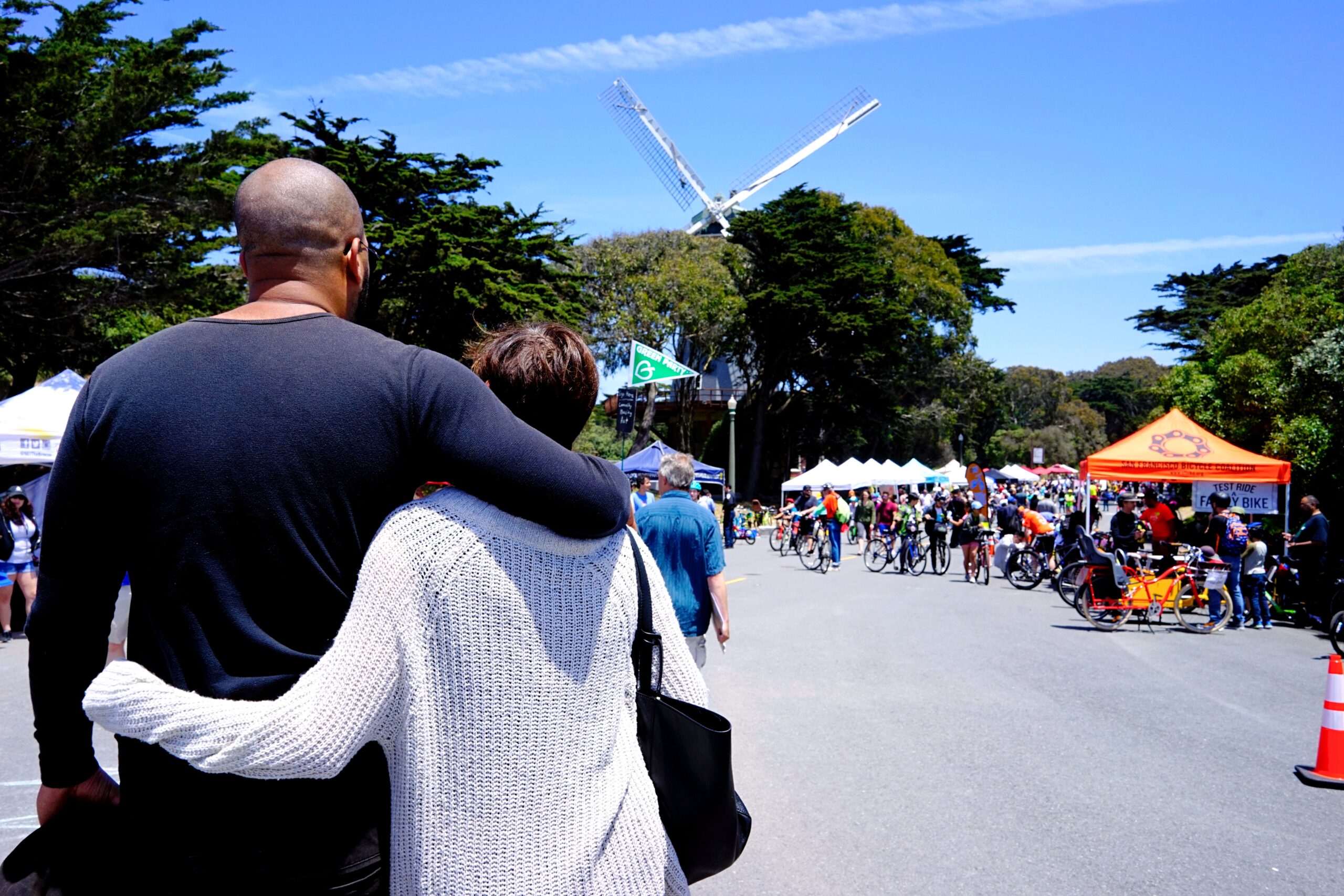
Sunday Streets Sunset/Golden Gate Park by Young Chau
May 23, 2019 FOR IMMEDIATE RELEASE mary@livablecity.org
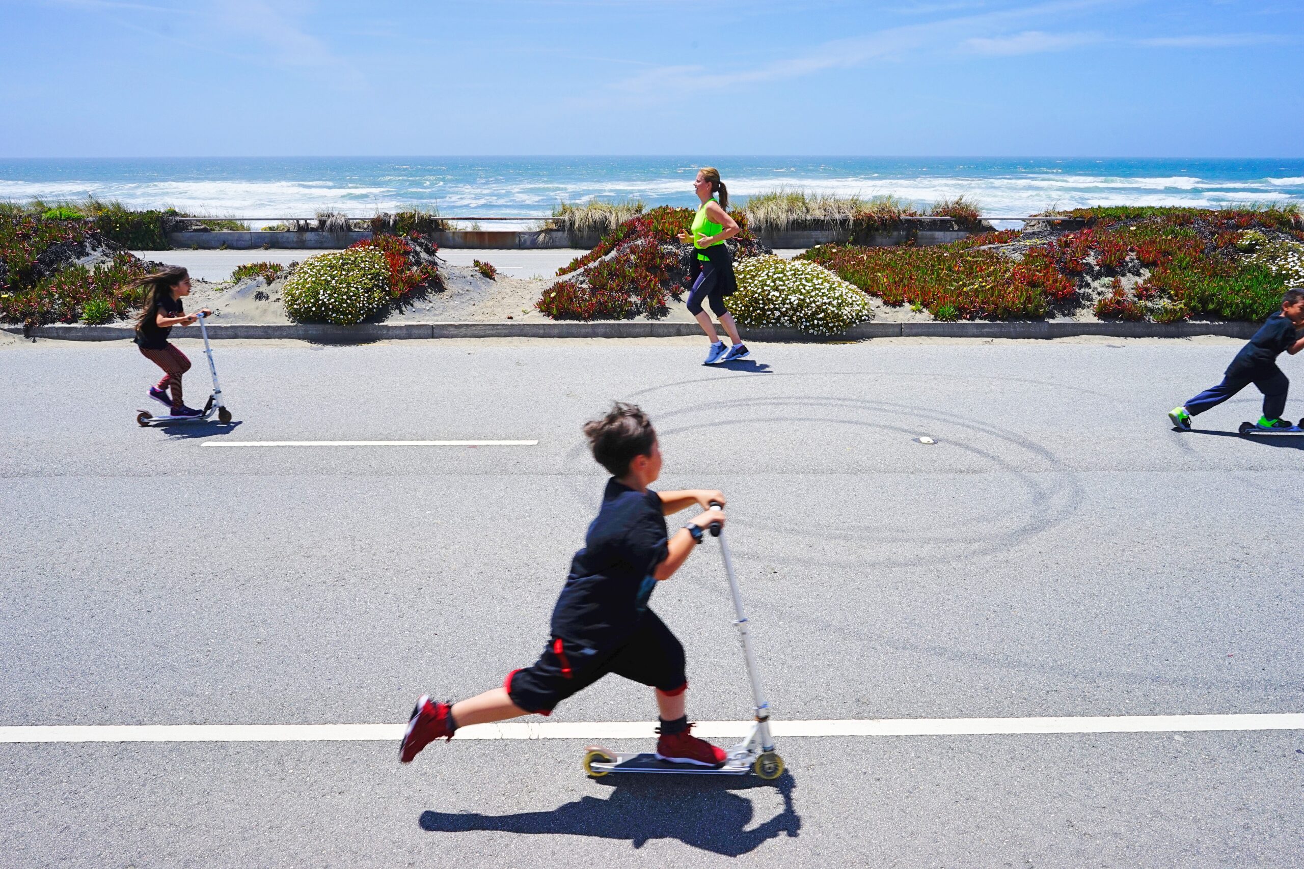
**PRESS RELEASE** San Francisco –– Experience over six miles of car-free streets on June 9 as Sunday Streets connects JFK Drive in Golden Gate Park all the way to the Great Highway at Sloat Boulevard from 11 a.m. to 4 p.m. The free event gives attendees a chance to experience open space and reclaim our streets for health, exercise and human connection.
The Sunset/Golden Gate Park route connects with SF Rec and Park’s car-free Sundays on the east side of JFK Drive. Activity Hubs are located inside the park at beautiful Spreckels Lake by the Bison Paddock, and Murphy Windmill, just inside the park near the intersection of MLK and Lincoln Drives.
While Sunday Streets usually brings open space to neighborhoods that lack it, this event is unique in that
expands upon car-free routes in the city’s premier open space in the city’s west side. As the City
explores making some streets permanently car-free, Sunday Streets lets San Franciscans envision how
that might look and feel in our world-class park.
“As we head into Golden Gate Park’s 150th anniversary next year, Sunday Streets helps us imagine how
we can use our park in the next 150 years as we respond to climate change and embrace sustainable
transportation as the primary mode of getting about our city and open spaces,” said San Francisco
Recreation and Park Department General Manager Phil Ginsburg.
Sunday Streets longest route of the season is an ideal place for both new and experienced bike riders –
along with roller-skaters, scooter-riders and people who use wheelchairs – to take in the beauty of the
coastline and world-renowned park without worrying about car traffic.
Free bike rentals from Ford GoBike, skip and JUMP will be readily available, along with SF Bicycle Coalition’s Freedom for Training Wheels program, which teaches toddlers and young children to ride a bike without training wheels in a safe, patient environment.
And be sure to pick up the Explore Local Map for a fun, reusable map of nearby small businesses, organizations and resources you can use all year round.
Inspired by the Ciclovía in Bogotá, Colombia, Sunday Streets is a series of free, fun open street events
empowering local communities to transform one to four miles of car-congested streets into car-free
community spaces for kids to play, seniors to stroll, organizations to connect and neighbors to meet.
Over a mile of cultural performances, health resources, live music and open space provides free
opportunities for all at ten yearly events.
Nonprofit Livable City runs both Sunday Streets and Play Streets, a program empowering neighbors to
transform their block into an accessible, car-free open space on a regular basis. Both programs are
sponsored by the SFMTA and other City agencies, and Sunday Streets would not be possible without
crucial services like Muni bus re-routing or traffic control officers for public safety.
Small businesses, residents, nonprofits and local groups bring activities, volunteers and performances to
the car-free routes, with each contributing a distinctive character and energy to the day. A local hire
program employs San Francisco residents for outreach and event-day support.
Transforming miles of car-dominated City streets into open space is possible through the collaboration
and hard work of hundreds of volunteers, neighbors, nonprofits and small businesses. Donate, exhibit,
volunteer or sponsor Sunday Streets in 2019 to be part of a sustainable, greener and more accessible
future. For more information, visit www.SundayStreetsSF.com.
Sunday Streets 2019 Season Schedule
March 10 – Mission 1 March 31 – Excelsior 1 April 14 – Tenderloin 1 May 5 – Bayview/Dogpatch June 9 – Sunset/GGP July 14 – Mission 2 August 18 – SoMa September 8 – Tenderloin 2 September 22 – Western Addition October 20 – Excelsior
The Sunday Streets 2019 season is made possible by the following season sponsors: Bay Area Air
Quality Management District (BAAQMD), San Francisco Department of Children, Youth & Their Families
(DCYF), Mission Housing Development Corporation, San Francisco Department of Public Works (SFPUC),
Genentech, Office of Economic and Workforce Development (OEWD), Sutter/CPMC, Ford GoBike,
iHeartMedia, Skip, Sutter/CPMC, iHeart Media, Jump Bikes and Xfinity/Comcast, and supporting sponsor
Canopy Health
About Sunday Streets
Sunday Streets is a program of the nonprofit Livable City, presented in partnership with the San Francisco
Municipal Transportation Agency and the San Francisco Department of Public Health and the Shape Up SF
Coalition. Additional City support comes from the Department of Public Works, Recreation & Parks
Department, SF Police Department, SF County Transportation Authority, San Francisco Mayor London
Breed and her offices and the SF Board of Supervisors.
About Livable City
Livable City is dedicated to increasing affordable housing, improving transportation, land use, open space,
and environmental policies, and supporting grassroots initiatives to make San Francisco a safer, healthier,
and more accessible city. For more information on Livable City, visit: https://livablecity.org. For more
information about Sunday Streets, including the Sunday Streets event activity guide, visit:
www.SundayStreetsSF.com. For information on Muni routes and vehicle access, call 511 or go to
www.sfmta.com
With heat waves threatening seniors in their homes, air quality crises grinding our city to a halt during last November’s fires, to the impending “big one,” San Franciscans are urgently asking, “How do we prepare for the next disaster?”
A growing body of research suggests that blowing bubbles and having a potluck with your neighbors might be the most effective way to survive. (source / source )
The City’s current disaster preparedness recommendation is to be able to shelter in place with enough food, water and medicine for three or more days and serve as the primary lifeline to the most vulnerable on your block. It means knowing your neighbors, their needs, and what they can bring to the table when outside aid is unavailable. And it will be one of the most important factors in whether you and your community survive the next disaster.
A 1995 Chicago heat wave killed 739 people, many of them elderly, low-income and African-American. But one Chicago neighborhood, despite sharing the same racial and income demographics, fared better than even affluent areas.
“It turns out that residents of Auburn Gresham participated in block clubs and church groups, in addition to socializing at grocery stores and diners, which many other neighborhoods lacked.
During the heatwave, the block clubs checked in on elderly and sick neighbors to ensure their safety—the neighborhood banded together.”
In response, San Francisco has invested not only in training residents and workers to be Neighborhood Emergency Response Teams (NERT), but also spearheaded an innovative block party program where neighbors can come together, map local resources and get trained on the basics of disaster resiliency called Neighborfest offered through the Neighborhood Empowerment Network (NEN).
Planning events like block parties creates capacity, because teams of volunteers must work together to design and implement the event. It creates social connection, both through the outreach needed to invite neighbors to the event, as well as providing the car-free space for people to meet on their own blocks. Knowing your neighbors means identifying where the most vulnerable live in your community – the elderly, those with mobility issues, the monolingual and undocumented who may be less likely to reach out to police or government.
That’s why things that may appear frivolous – bubbles, hopscotch, hula hoops and potlucks – create the tools that bring people together and create the connection needed to respond to disaster.
As San Francisco becomes more expensive, longtime residents and families are driven out, and the social connections generations of people create often move out with them. Many people don’t know their neighbors, or aren’t able to remain in their homes long enough to get to know who lives nearby.
Sunday Streets and Play Streets, Livable City’s biggest programs, provide public health benefits through open space and free recreation. But they also create resiliency the same way the Neighborfest program does – through connecting residents, small businesses and other stakeholders to organize for and plan the event, as well as creating the space for people to come together and meet.
While Sunday Streets started out as a program focused on recreation, it has expanded to host cultural celebrations – like this year’s Thai New Year in Little Saigon – and provide common space and Play Streets Pop-Ups for kids. This programming encourages attendees to stick around, meet their neighbors and explore the resources in (and get more familiar with) their neighborhoods.
Play Streets (Sunday Streets’ “little sibling”) operates much like Neighborfest, creating capacity through organizing teams who invite residents on their blocks and work together to plan for the events. Outreach like door-knocking (however intimidating it may feel at first) creates connection where they may have been none before, and even if neighbors don’t attend, they still get a chance to meet others who live nearby. Lastly, simply providing games and activities for children and seating for adults draws people from their homes and out into the streets with the surrounding community.
Livable City is thrilled about the response to the Play Streets program as well as its emerging partnership with the NEN to expand the Neighborfest Program.
As Play Streets grows (and partners with Neighborfest to provide important training tools like resource mapping and resiliency workshops), the recurring events provide a reliable space a neighborhood can anticipate and plan for. These community-driven activities provide a reliable space for neighbors to come together, exercise, have fun, build stronger connections and celebrate their community. In other words – build a healthier, safer and more resilient San Francisco.
San Franciscans Can Now Transform Their Block Into a Car-Free Temporary Park On A Daily, Weekly or Monthly Basis
***PRESS RELEASE***
San Francisco – Applications are now open for the 2019 season of Play Streets SF, a program empowering San Francisco residents to throw their own series of play-focused block parties and transform their street into an accessible, car-free open space for children, seniors and neighbors to connect. Residents citywide can now get information and apply for their own Play Streets at sfplaystreets.org.
With a mission to create healthier, more connected and resilient communities, Play Streets SF provides residents and local organizing teams with the tools needed to reclaim their street for community health and connection – from hassle-free permitting to free safety equipment, outreach tools, and play equipment.
Play Streets SF launched in 2017 with an equity-first pilot to ensure the citywide launch was accessible and responsive to the communities who needed it most in San Francisco – African American, Latino, Chinese, Pilipino, and Samoan/Pacific Islander communities who all experience disproportionately high rates of poor health outcomes. For the first two seasons, Play Streets SF worked with communities in San Francisco’s most underserved neighborhoods in terms of open space and recreational opportunities, which also correlates closely with San Francisco’s largest minority communities including Bayview/Hunters Point, Sunnydale/Visitacion Valley, Chinatown, and the Excelsior.
Through these collaborations, Livable City has developed a host of resources for the 2019 Play Streets season. From free rentals for easy-to-host recreational activities like hopscotch, jump rope and street soccer to posters and flyers that are translated into multiple languages, Play Streets SF helps all San Francisco residents focus on community building and fun with their neighbors.
“With Sunday Streets – Play Streets big sister – we work with diverse stakeholders to reimagine entire corridors as public spaces,” said Programs Director Katy Birnbaum. “Through the act of sharing that rare abundance, we are able to foster community connections that serve the neighborhood when we’re not in the streets with them.”
Play Streets “puts those same resources of open space and play into the hands of neighbors so they can do that work, block by block, to make us a more connected and resilient city,” Birnbaum said.
With three to six sessions, each Series provides a reliable structure and community space residents can anticipate and plan for, and regular sessions are especially important in neighborhoods that lack open space and recreational opportunities. With three or more sessions, residents become familiar with the program and join in to help, while children quickly catch onto the schedule.
Play Streets SF a program of SFMTA presented in partnership with the nonprofit Livable City, home to Sunday Streets, San Francisco’s open streets program since 2008. Additional support is provided by SF Department of Public Health (SFDPH), Department of Children, Youth and Families (DCYF), and the SF Planning Department.
For more information and to apply for a Play Streets permit, San Francisco residents and community members citywide are encouraged to visit sfplaystreets.org.
About Play Streets
Play Streets SF is a program of SFMTA presented in partnership with the nonprofit Livable City with additional support provided by SF DPH, DCYF, and SF Planning. Play Streets came to San Francisco in 2017 as a two-year pilot with 30 sessions and eight-pop-ups between Visitacion Valley, Chinatown, the Excelsior and Mission/Bernal Heights.
SFMTA and Livable City are actively seeking partners and sponsors for SF Play Streets in 2020 and beyond. Contact us at PlayStreets@livablecity.org for more information
About Livable City
Livable City is dedicated to increasing affordable housing, improving transportation, land use, open space, and environmental policies, and supporting grassroots initiatives to make San Francisco a safer, healthier, and more accessible city. Livable City is home to Sunday Streets, the City’s open streets program. For more information, visit:LivableCity.org and SundayStreetsSF.com.
San Francisco – On May 5, Sunday Streets is thrilled to present the first
annual Bayview Faith Festival at Carroll Avenue, bringing faith communities together for a
day of service, worship, praise, and celebration during Sunday StreetsBayview/Dogpatch, with a car-free route on Third Street from 22nd Street to
Carroll Avenue.
At the main stage, enjoy the Olivet Baptist Church Band,
nationally acclaimed gospel singers, Bayview gospel legends, spoken word,
Bayview’s Got Talent Contest winners, faith services and raffles and giveaways
all day. Savor the Taste of the
Southside Brunch Garden hosted byDr.
George W. Davis Senior Center with delicious food specials
created by the chefs behind the Black Cuisine Festival – all benefitting the
Center!
“Growing up in Bayview, the faith community has always been one of
the strongest and positively influential forces,” said neighborhood resident
and open streets advocate Maya Rodgers. “It’s exciting to see the faith
community engaged and doing something as inspirational as the Faith Festival.”
The
festival connects congregations and the broader Bayview/Hunters Point community
to important health, financial, and educational resources for the whole family,
including information
about local construction, transit, and greening projects.
Project experts from SFMTA and Vision Zero will be on hand, providing
neighborhood residents and visitors direct access to transit planners and ambassadors
dedicated to sustainable streets. Attendees can partake in free bike and scooter rentals, health resources including blood
pressure screenings and local hire program information.
The Faith Festival is lead by Planning Chairs Pastor
Kirk Davis and Reverend Ishmael Burch and Entertainment Director Reverend
Marcus Johnson in collaboration with Sunday Streets/Livable City and the SF
Office of Economic and Workforce Development.
Inspired by the Ciclovía
in Bogotá, Colombia, Sunday Streets is a series of free, fun open street events
empowering local communities to transform one to four miles of car-congested
streets into car-free community spaces for kids to play, seniors to stroll,
organizations to connect and neighbors to meet. Over a mile of
cultural performances, health resources, live music and open space provides
free opportunities for all at ten yearly events.
Nonprofit Livable City
runs both Sunday Streets and Play Streets, a program empowering neighbors to
transform their block into an accessible, car-free open space on a regular
basis. Both programs are sponsored by the SFMTA and other City
agencies, and Sunday Streets would not be possible without crucial services
like Muni bus re-routing or traffic control officers for public safety.
Small businesses, residents, nonprofits and local
groups bring activities, volunteers and performances to the car-free routes,
with each contributing a distinctive character and energy to the day. A local
hire program employs San Francisco residents for outreach and event-day
support.
Transforming miles of car-dominated City streets
into open space is possible through the collaboration and hard work of hundreds
of volunteers, neighbors, nonprofits and small businesses. Donate, exhibit,
volunteer or sponsor Sunday Streets in 2019 to be part of a sustainable,
greener and more accessible future. For more information, visit
www.SundayStreetsSF.com.
Sunday Streets
2019 Season Schedule
March 10 – Mission 1
March 31 – Excelsior 1
April 14 – Tenderloin 1
May 5 –
Bayview/Dogpatch
June 9 – Sunset/GGP
July 14 – Mission 2
August 18 – SoMa
September 8 – Tenderloin 2
September 22 – Western
Addition
October 20 – Excelsior 2
The Sunday Streets 2019 season is made possible by the
following season sponsors: Bay Area Air Quality Management District
(BAAQMD), San Francisco Department of Children, Youth & Their Families
(DCYF), Mission Housing Development Corporation, San Francisco Department of
Public Works (SFPUC), Genentech, Office of Economic and Workforce Development
(OEWD), Sutter/CPMC, Ford GoBike, iHeartMedia, Skip, Sutter/CPMC, iHeart Media,
Jump Bikes and Xfinity/Comcast and
supporting sponsors Pier 70, Dayspring Technologies and UCSF
About Sunday Streets
Sunday Streets is
a program of the nonprofit Livable City, presented in partnership with the San
Francisco Municipal Transportation Agency and the San Francisco Department of
Public Health and the Shape Up SF Coalition. Additional City support comes from
the Department of Public Works, Recreation & Parks Department, SF Police
Department, SF County Transportation Authority, San Francisco Mayor London
Breed and her offices and the SF Board of Supervisors.
About Livable City
Livable City is
dedicated to increasing affordable housing, improving transportation, land use,
open space, and environmental policies, and supporting grassroots initiatives
to make San Francisco a safer, healthier, and more accessible city. For more
information on Livable City, visit:https://livablecity.org. For more
information about Sunday Streets, including the Sunday Streets event activity
guide, visit: www.SundayStreetsSF.com. For information on Muni routes and
vehicle access, call 511 or go to www.sfmta.com
Sunday Streets Sunset/Golden Gate Park transforms the Great Highway. Photo by Young Chau
By Marynoel Strope
“Why is Sunday Streets so spread out?”
“Why not have it all one one block? It would be so much busier!”
“Sunday Streets should sell alcohol to bring more people in!”
While Sunday Streets San Francisco’s Activity Hubs can feel like a street fair, there’s a big difference: Sunday Streets is an open streets program, with routes one to four miles in length and a mission to reimagine our streets as public spaces for public health and social connection.
Through its roots with the Shape Up SF Coalition, Sunday Streets was founded on the principles of HEAL (Healthy Eating, Active Living) Campaign, harnessing the power of local governments to advance health equity and address health disparities. HEAL legislation mandates everything from healthy food options in public meetings to PE time for youth in public schools.
“Cities, communities and neighborhoods can be places where physical, social and economic conditions make health a reality for all,” according to HEAL. And that’s just what open streets do – use existing city infrastructure to create safe space for recreation.
This focus on health guides Sunday Streets. Unlike most festivals, Sunday Streets doesn’t serve or sell alcohol and the event’s sampling guidelines ensure the day isn’t full of junk food and sugar-sweetened beverages. In accordance with HEAL, encouraging active living and healthy eating is a core part of the Sunday Streets mission.
These policies affect the way the Sunday Streets team works, too – the office even has a health captain who helps maintain the Livable City office for health and wellness.
Open Streets Vs. Street Fairs
Most people are used to street fairs and festivals, which tend to pack a lot of programming into a few blocks. Open streets programs do what many street fairs do not: provide enough open space for attendees to complete their weekly exercise, just by walking (or rolling) from one Activity Hub to another. International standards recommend routes of three to 10 miles in length for this very reason – while block-long events are fun and worthwhile, they just don’t provide the public health benefits of an open street program.
Sunday Streets transforms car-clogged city streets into safe, temporary parks and prioritizes neighborhoods (like the Tenderloin) who lack access to open space and recreation. These lower-income neighborhoods suffer from extreme health disparities as compared to wealthier, less racially diverse areas.
The Case for Streets as Parks
There are other types of temporary parks, such as the parklets that pop up in the parking lane, providing seating, greenery and space for social connection. While an asset to city streets, their small footprints do not provide enough space for active recreation, and their proximity to cars make them less safe than an enclosed park.
Safety is a key component to creating a successful space for both active (biking, jogging, hula-hooping) and passive (card games, socializing and art projects) recreation – and open streets programs provide a sense of safety that city residents cannot get while dodging cars on a city street on a regular day. The sense of safety means people stick around longer, and feel comfortable moving about without risk of injury.
And providing this fun, safe space has another health benefit – one you can get even if you’re not exercising.
A Space for People of All Ages and Abilities
Studies have shown social connection has positive mental and physical health benefits. Open streets programs that create common areas help ease loneliness, as well as provide a low-barrier way for those with limited mobility to participate and enjoy the day. The simple act of going outside and seeing your neighbors can improve mental and physical health.
In an increasingly competitive San Francisco – where we all must compete for jobs, seats on the bus or at a cafe, on our sidewalks as pedestrians, and especially for housing (indeed, for space itself), open streets programs create a non-competitive environment. They show that there is enough space for everyone if we reimagine our streets as public spaces.
Room to Dream Big and Heal through Imagination
Long routes also provide endless space for programming and fun activities that draw people in so they can reap the benefits of open streets. Sunday Streets’ collaborative model and mile-plus length allows for residents, small businesses and local organizations – the stakeholders who know the neighborhood best – to dream big and bring important cultural events and celebrations to the day.
This process encourages capacity-building, especially in underserved communities, supporting creativity and imagination as community members bring their ideas to life and out into the streets.
From entire orchestra performances to collaborative mural painting to low-rider bike shows, the long footprint of the events means that there is always room to plan something big – and that activity just may take place right outside your front door.
April 9, 2019 FOR IMMEDIATE RELEASE Mary Strope Communications Manager O (415) 344-0489 | mary@livablecity.org
PRESS RELEASE
Sunday Streets Tenderloin Brings a Thai New Year Festival to Little Saigon – Plus Over a Mile of Free Activities, Music and Open Space For All
San Francisco – Sunday Streets brings car-free fun to the Tenderloin and Civic Center on April 14, transforming car-congested streets into open space with live musical performances, free activities and fun for the whole family on Larkin, Ellis and Jones Streets and Golden Gate Avenue from 11 a.m. to 4 p.m. New this year, enjoy the first annual San Francisco Thai New Year celebration in Little Saigon.
Two blocks of Larkin Street between Eddy and O’Farrell will transform into a cultural festival for a day of fun, food and celebration of San Francisco’s Southeast Asian communities, all taking place in conjunction with Sunday Street Tenderloin. Enjoy a stage, live bands, Muay Thai boxing demonstrations, traditional Southeast Asian dances and a Southeast Asian fashion show. Savor small bites from world-renowned Lers Ros Thai and other Tenderloin institutions, a Thai beer garden and a marketplace featuring neighborhood makers.
Bring kids for bounce houses and games at the festival or over a mile of free activities and open space as Sunday Streets transforms the Tenderloin into a temporary park for the day. At Civic Center, celebrate all things local with the 415 Day Stage and vendors. Bring kids for a Play Streets Pop-Up presented with Civic Center Commons, complete with lawn games, pickup basketball and SF Rec and Park’s Mobile Rock Climbing Wall. From 11 a.m. to 2 p.m., catch Awesöme Orchestra Collective in partnership with SF Public Library’s Main Branch.
Project Experts from the SFMTA will be on hand on to answer questions about safety improvements in the area. As a primary sponsor of all Sunday Streets events, neighborhood residents and visitors can enjoy direct access to transit planners and ambassadors dedicated to sustainable streets. And don’t forget to pick up the Explore Local Guide for a fun map of the Tenderloin to use all year long.
Inspired by the Ciclovía in Bogotá, Colombia, Sunday Streets is a series of free, fun open street events empowering local communities to transform one to four miles of car-congested streets into car-free community spaces for kids to play, seniors to stroll, organizations to connect and neighbors to meet. Over a mile of cultural performances, health resources, live music and open space provides free opportunities for all at ten yearly events.
Nonprofit Livable City runs both Sunday Streets and Play Streets, a program empowering neighbors to transform their block into an accessible, car-free open space on a regular basis. Both programs are sponsored by the SFMTA and other City agencies, and Sunday Streets would not be possible without crucial services like Muni bus re-routing or traffic control officers for public safety.
Small businesses, residents, nonprofits and local groups bring activities, volunteers and performances to the car-free routes, with each contributing a distinctive character and energy to the day. A local hire program employs San Francisco residents for outreach and event-day support. Transforming miles of car-dominated City streets into open space is possible through the collaboration and hard work of hundreds of volunteers, neighbors, nonprofits and small businesses. Donate, exhibit, volunteer or sponsor Sunday Streets in 2019 to be part of a sustainable, greener and more accessible future. For more information, visit www.SundayStreetsSF.com.
The Sunday Streets 2019 season is made possible by the following season sponsors: Bay Area Air Quality Management District (BAAQMD), San Francisco Department of Children, Youth & Their Families (DCYF), Mission Housing Development Corporation, San Francisco Department of Public Works (SFPUC), Genentech, Office of Economic and Workforce Development (OEWD), Sutter/CPMC, Ford GoBike, iHeartMedia, Skip, Sutter/CPMC, iHeart Media, Jump Bikes and Xfinity/Comcast
About Sunday Streets Sunday Streets is a program of the nonprofit Livable City, presented in partnership with the San Francisco Municipal Transportation Agency and the San Francisco Department of Public Health and the Shape Up SF Coalition. Additional City support comes from the Department of Public Works, Recreation & Parks Department, SF Police Department, SF County Transportation Authority, San Francisco Mayor London Breed and her offices and the SF Board of Supervisors.
About Livable City Livable City is dedicated to increasing affordable housing, improving transportation, land use, open space, and environmental policies, and supporting grassroots initiatives to make San Francisco a safer, healthier, and more accessible city. For more information on Livable City, visit: https://livablecity.org. For more information about Sunday Streets, including the Sunday Streets event activity guide, visit: www.SundayStreetsSF.com. For information on Muni routes and vehicle access, call 511 or go to www.sfmta.com
With cars so deeply ingrained in both people’s everyday lives and the city’s infrastructure, it can be difficult to imagine a future without the automobile. Roads are built for them, giant parking structures exist countrywide to store them, and even sidewalks regularly give way to driveways.
But with every new climate change report, it’s clear – cars are not part of a sustainable future. In California, the largest source of carbon emissions comes from driving. And despite the state’s efforts to lead in environmental policy, emissions from greenhouse gases have been on the rise for the past few years.
As we saw with the story of Ciclovía – Bogotá, Colombia’s open street program and the largest and oldest one worldwide – open streets cannot just stand on their own to create change. Even one day a week where almost an entire city of 8 million people gain access to car-free streets has not solved the pollution and traffic problems caused by cars in Bogotá.
But open streets programs remain a powerful way of modeling a car-free future – exposing people not just to what human-scale public space looks like, but what sustainable transportation feels like. Beyond a fun way to exercise and socialize, they provide a model for what could be.
Since fewer people are driving, open street programs help clear the air – LA’s CicLAvia improves air quality by reducing ultrafine particles in the air by over 20 percent, while a “study conducted in Bogotá reveals that particulate matter along the city’s Ciclovía route was 13 times higher on a regular weekday than on a Sunday.”
If a single day of less driving can significantly improve the air quality (albeit temporarily), then permanently establishing car-free streets could provide ongoing positive effects on air quality.
Beyond air quality, open streets programs re-introduce neighborhoods to residents as places to travel sustainably – either on foot, bike or scooter. Studies have shown that open streets don’t just provide needed exercise, they encourage exercise outside of the events. At open street events like Sunday Streets, that exercise largely coincides with sustainable transportation. When there is no option to take a gas-guzzling vehicle, attendees can see how walkable, bikeable and rollable their streets really are.
Despite better-than-average bike infrastructure and public transit, cars are largely the mode of transport in San Francisco, and often the fastest and most accessible way to get around. It’s a reflection of the way our city’s infrastructure has shifted to serve the automobile first.
It wasn’t always that way. In fact, for most of the country’s history, communities were centered around other things – bodies of water, train stations, or communal gathering spaces like squares or marketplaces. In older cities, many of the roads we drive down today started as walking trails created over centuries by Native peoples.
New York City’s Broadway is one of the most famous examples, which began as a trail of the Canarsee Indians of the Lenape following a ridge and stretching from one end of Manhattan to the another.
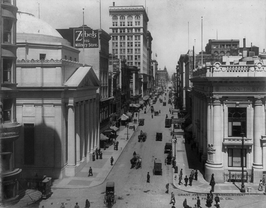
While human beings have been carving roads and paths for eons, it’s easy to forget that cars are quite new. Before automobiles, roads were shared spaces – open to pedestrians, vendors and modes of transport like horses and buggies. Children played in the streets freely and jaywalking just didn’t exist. Photos from the time show streets full of people and children traveling, eating, playing, socializing, shopping and crossing every which way.
The Automobile Land Grab & The Invention of Jaywalking
With the production of the first affordable, fast automobile – Henry Ford’s Model T- a calculated shift towards a car-focused society began to take place, spurred on by the automobile industry’s profit-seeking motives. Charles Hayes, president of the Chicago Motor Club, decided “it was time to target not the behavior of cars—but the behavior of pedestrians.”
A public relations campaign shaming jaywalkers (a newly-created term) and pedestrians placed the blame squarely on humans at a time when many were deeply troubled by the deaths caused by auto accidents. Interestingly, ‘jaywalker’ came from the word from the slang ‘jay’, meaning ‘ignorant bumpkin’. Before it was used to describe wayward pedestrians, the term actually described unruly drivers – “A jay driver is a species of the human race who, when driving either a horse or an automobile, or riding a bicycle on the streets, does not observe the rules of the road. It is the custom of the jay driver to drive on the wrong side of the street.”
The decade also saw the rise of planned “residence parks” – suburban-style neighborhoods like St Francis Wood – designed for drivers, not pedestrians. “Apartment houses, groceries, laundries, saloons, stables, or undertaking establishments” were not permitted in these decidedly non mixed-use communities, where wealthy residents were expected to drive to services and retail.
Invasion of The Freeway
By 1948, the city’s Trafficways Plan envisioned a city criss-crossed with eight freeways, from the Mission to the Sunset. Redevelopment was on its way as modernist architects and planners envisioned a car-dominated city of the future, where buildings were massive and set far back from the streets. Pedestrians were relegated to walkways, often above or below street level, and planners shifted land use to accommodate parking spaces and structures.
The most infamous redevelopment project was the razing of a 36-block zone in the Western Addition, a plan first submitted in 1947. The planning department’s intention was clear: to create a whiter, wealthier neighborhood from the dense, culturally thriving African American district (which was also one of the city’s most racially integrated and diverse), and demolish Victorian homes in favor of scattered large, setback developments.
“It was mutually-assured destruction,” Livable City Executive Director Tom Radulovich said of the new modernism. “Streets got more dangerous, and buildings withdrew from the street. It eroded city life.”
The plan decimated the community, including its world-class jazz scene, razing blocks of old Victorians and leaving empty lots in their place, some of which lingered into the 70s and 80s. Though residents were promised a right to return, few were actually given the option. The area’s significant Japanese population, who’d been forced out and placed in camps during World War 2, were paid tribute in a modernized Japantown, bordered by the brand-new, high-speed and highly unwalkable Geary Boulevard. But few people of Japanese descent moved back to the new area, with its stylized architecture, shopping malls and raised pedestrian walkways.
Today, San Francisco, like many American cities, still suffers the negative effects of the era’s redevelopment projects. Lower Fillmore Street, rebuilt with giant high-rises and large blocks of public housing, failed to provide the social cohesion – and even volume of housing – the old neighborhood had, and efforts to revive the commercial corridor continue to be a challenge, especially in an age of vast wealth inequality and racial disparities.
The Bayview also changed when the 101 freeway replaced the old Bayshore Highway, transforming a bucolic beachside neighborhood served by streetcars to a traffic thoroughfare. Though it’s home to the T, the city’s first light rail line in half a century, the line’s service has been spotty, failing to serve the area’s residents – many of them the descendants of African Americans displaced during Western Addition’s redevelopment. Other major traffic thoroughfares, like San Jose Avenue, are not freeways per se, but were established to cut through the city to accommodate cars, and are decidedly not pedestrian-friendly.
With their centrally located commercial corridors, walkable neighborhoods built in the pre-car era remain the most desirable today. Others, like Parkmerced with its high-rise clusters bordering high-traffic thoroughfares, show the legacy of modernism.
Developers still favor – and continue to build – giant, boxy high rises, but many of the large, bottom-floor retail spaces make up long-term vacancies, further eroding city life. Though malls like the Sunset’s Stonestown are losing anchor retailers, and Union Square is dotted with vacant buildings, a 250,000-square-foot mall was constructed on central Market Street in 2010 in an effort to revitalize the area. Today, the mall sits empty, anchored only by a parking garage.
Before cars took over the bustling city of San Francisco, people walked and used public transit to get around. A 1927 San Francisco study found that “streetcars were used by 70 percent of the people depending on some kind of transportation to get downtown, while only a quarter used passenger cars, but the latter made up 61 percent of vehicular traffic as compared to 11 percent for the streetcars”. The second level of the Bay Bridge was devoted to light rail, which came to a stop in 1958.
From Neighbors to Poet Laureates: San Francisco Fights The Car
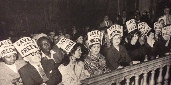
Freeway protesters in City Hall, 1966 Photo: San Francisco Chronicle
Resistance followed redevelopment, and similar projects in the Mission were halted due to opposition. The resistance didn’t stop at car-focused city planning, though, and in the 1950s and 60s a series of protests known as the Freeway Revolt put a stop to the Trafficways plan.
Many people resisted automobile dominance. In the 20s, the San Francisco electorate twice defeated amendments to build underground parking in public parks. Still, the City pushed on, eliminating trolly and cable car lines in favor of the buses that get stuck in car traffic.
BART began providing an efficient public transit alternative to City buses in 1972, at time when more and more people were advocating for environmental sustainability. With only eight stops in San Francisco, the finished system was a far cry from the original proposal, which served far more SF neighborhoods, as well as Marin County. The following year, SFMTA adopted a “transit-first” policy it still has today, though few political leaders have signed on to make the policy a reality.
The 1989 Loma Prieta earthquake changed the landscape yet again, damaging both the Embarcadero and Central Freeways. While the waterfront-hugging Embarcadero Freeway quickly came down, the Central Freeway’s fate was unclear. Cycling and livability advocates were gaining steam, and the issue was put to the voters three times.
“What destroys the poetry of a city? Automobiles destroy it, and they destroy more than the poetry,” Lawrence Ferlinghetti said in his inaugural address as Poet Laureate of San Francisco in 1998.
“All over America, all over Europe in fact, cities and towns are under assault by the automobile, are being literally destroyed by car culture. But cities are gradually learning that they don’t have to let it happen to them.”
Ferlinghetti urged San Franciscans to vote to replace the Central Freeway with a boulevard. A Central Freeway Citizens Advisory Council was established, and ultimately, city street Octavia Boulevard replaced the big, bulky freeway’s right-of-way.
1999 saw the city’s first “road diet” on Valencia Street, transforming the street with new bike lanes and creating a model that would be followed, albeit piecemeal, in street improvements citywide. Widening sidewalks, adding bulbouts, greening with parklets, trees and plants and creating protected better biking and transit infrastructure have become the best practice to create walkable, bikeable streets.
Today, the movement to pedestrianise city streets and reclaim them from cars coincides with movements for transit, environmental and economic justice. After many years, Livable City’s fight to eliminate minimum parking requirements saw a victory this year. While cars still dominate – and the rise of TNCs have dumped thousands more daily on city streets – both major boulevard Market Street and the Mission’s Valencia are continually brought up as ideal streets for year-round car-free spaces. SFMTA has begun to study the feasibility of car-free streets that would be open to pedestrians, bicyclists and city buses. But such a shift to a multi-modal future isn’t easy.
“Optimizing streets for cars is pretty simple,” said Radulovich. “But if you really think multi-modal, you need a much more complex and nuanced vision. Cities are complex, and you have to approach them with a certain level of humility.”
