Poets Plaza, a proposed piazza in North Beach, has been delayed again. Supporters have started an online petition to get the project moving. There will be a public meeting about the piazza on Thursday, March 3 from 6 to 7:30 pm at the Tel-Hi Center, 660 Lombard Street near Mason.
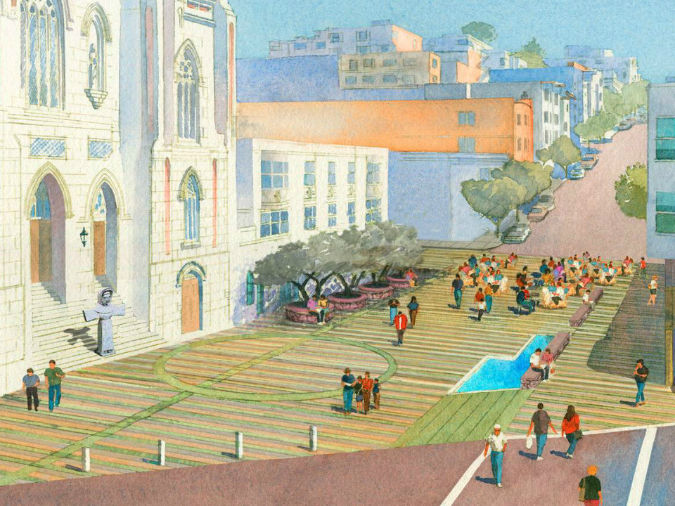
Rendering of Piazza Saint Francis, the Poets Plaza
The plaza, also called Piazza Saint Francis, would reside on the block of Vallejo Street between Grant and Columbus avenues, in front of St. Francis of Assisi Church. Lawrence Ferlinghetti, poet and owner of City Lights Books, first proposed Poet’s Plaza in 1998. “I viewed this plaza as a great public space where writers of all generations and nationalities could come and recite their works (with quotes from great poets incised in the paving stone) — a plaza that would become the active literary center of the city.”
Former City supervisor Angela Alioto is the project’s energetic proponent, and the current design envisions a pedestrian plaza reminiscent of Umbria, an Italian region of hill towns that St. Francis called home – paved in bands of stone incised with lines of poetry, with a fountain, benches, and olive trees.
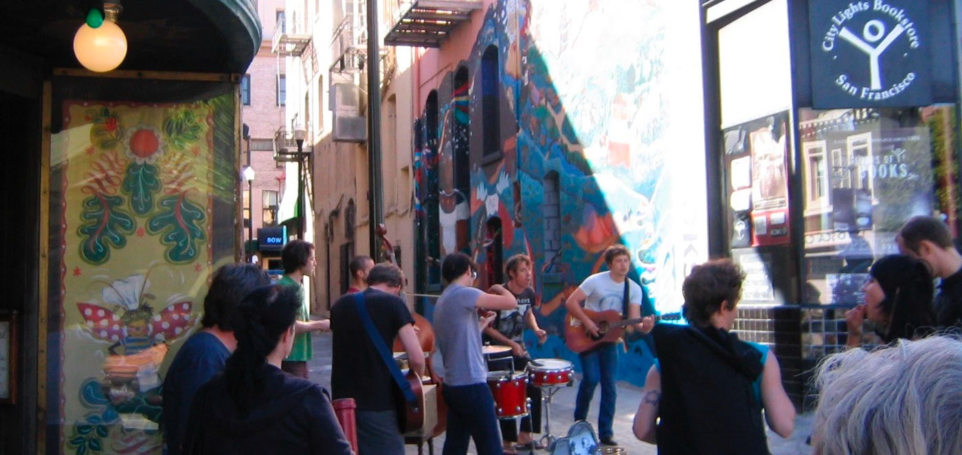
Ferlinghetti also championed improvement of Jack Kerouac Alley next to City Lights Books. The alleyway connects Chinatown and North Beach. It was remodeled and closed to autos in 2007, and its new paving is inset with lines of poetry in English and Chinese.
Ferlinghetti wrote: “Inner cities around the country are learning tardily that they do not have to allow the automobile and its car culture to overrun them.” Projects like Poets Plaza and Jack Kerouac Alley are part of a larger, worldwide movement to reclaim city streets for people. Hundreds of streets across the Americas, Asia, and Europe have become car-free. Car-free streets may be temporary or permanent.
San Franciscans have enthusiastically embraced temporary car-free streets. Portions the roads through Golden Gate Park are car-free every Saturday and Sunday. Starting in 2008 with two events, Sunday Streets has grown to eight annual events that attract tens of thousands of San Franciscans. San Francisco’s street fairs and festivals are a longstanding tradition. Neighbors organize block parties and play streets, and Livable City is working to make the process easier.
San Francisco, like many US cities, has been slow to embrace permanent car-free streets, despite many successful examples around the world, and home-grown successes like Jack Kerouac Alley, Mint Plaza, Maiden Lane, and the City’s wonderful staircase streets. Part of the problem is the lingering notion in planning circles that car-free streets don’t work. In the 1950s and 60s, many American downtowns, large and small, were facing a crisis as the advent of television and the automobile brought about a decline in downtown shopping and theater districts. Several cities experimented with pedestrianizing shopping streets. Pedestrianized streets often continued their decline, and pedestrianization was blamed for making it worse. By the 1970s and 80s many American planners concluded that pedestrian precincts don’t work, and auto traffic to many car-free streets.
Jack Kerouac Alley, Chinatown / North Beach
Urbanists like Jan Gehl and the late John Roberts identified the necessary ingredients of successful city-center car-free streets. Strong character, including great buildings and historic neighborhoods, draws people. A mix of uses and activities – housing, offices, restaurants, bars and cafes, shops, hotels, entertainment, and cultural institutions – creates activity throughout the day and into the night, making streets lively and safe. Sustainable transportation options – public transit, a bicycle network, and a network of walkable streets – provide mobility. Streets and plazas should be well-designed and maintained. Blocks should be short and streets well-connected. Human-scaled buildings are important – buildings tall enough and close enough to create a sense of snugness and enclosure, but not so tall as to put public spaces in permanent shade. In cool and windy San Francisco, sunlight on sidewalks and in parks keeps them comfortable and inviting.
Many San Francisco streets have all the right ingredients to be successful car-free streets – a mix of uses, a strong character, good transit, and human-scaled buildings. North Beach is well-suited to car-free streets – Poet’s Plaza, and also Grant Avenue, as Ferlinghetti and others have noted. As Ferlinghetti said in his inaugural address as Poet Laureate of San Francisco, auto traffic can destroy the poetry of the city. Car-free streets can help us hear it again.
The vision of an interconnected Greenway Network of trails and parks across San Francisco’s San Miguel Hills continues to take shape, with three projects poised to move ahead in the next few months. These open spaces extend from Golden Gate Park to Glen Park. Encompassing peaks, canyons, forests, grasslands, streams, and lakes, the greenway network supports recreation, habitat and watershed restoration, and enjoyment of nature and views.
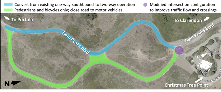
Twin Peaks Figure 8 Pilot Project
On Twin Peaks, SFMTA and Parks and Recreation have proposed closing the eastern half of Twin Peaks Boulevard’s ‘figure 8’ to auto traffic. The eastern roadway would become a car-free space for walking, cycling, and enjoying panoramic views of San Francisco and the bay. Auto traffic will use the western roadway.
SFMTA is holding two public hearings on the pilot project. Supporters are encouraged to attend, or to write an email in support of the pilot.
Tuesday, April 19, 2016 at 1:00 pm*
San Francisco City Hall, Room 400 mtaboard@sfmta.com
* subject to change
Twin Peaks Mt. Sutro Connector Trail
Earlier this month, Parks and Recreation held a public meeting on plans for a walking and cycling trail between Twin Peaks to Mt Sutro. The proposed trail would skirt the Twin Peaks Reservoir and Sutro Tower to connect Clarendon Avenue to Twin Peaks. Recreation and Parks will complete design and environmental review this spring, and will organize volunteers to build the trail this summer.
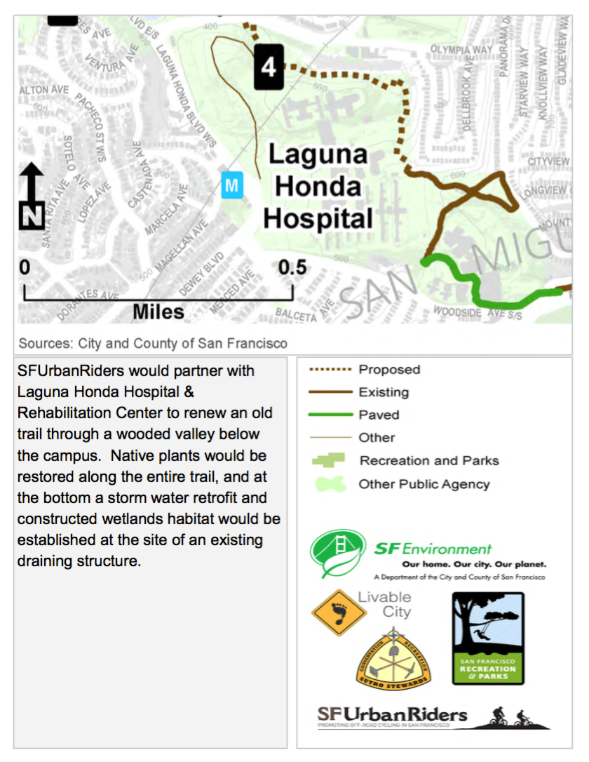
Laguna Honda Community Trail Project
SF Urban Riders are working with the Department of Public Health, Livable City, and other partners to reopen an historic trail through the Laguna Honda Hospital grounds. The trail project parallels a natural creek that drains from Twin Peaks into Laguna Honda, and includes creek, wetland, and native plant restoration. There will be a walking tour and public meeting about the project on Tuesday, March 15. The walking tour is from 5:30 to 6:30, starting at the Forest Hill Muni station, and the meeting is from 6:30 to 7:30 pm in the Laguna Honda Administration Building, room B102.
San Francisco faced big challenges with equity and affordability in 2015. Still, the city made major progress by building and preserving affordable housing, planning better neighborhoods, reclaiming streets for people, making room for nature, lessening automobile dependence, and fostering a shift towards sustainable transportation. Let’s take a look at the year in livability:
San Francisco’s Voice for Livability
Livable City continued to be the city’s leading voice for livability, in the media, in City Hall, and at public forums.
This year, we organized a three-part forum series and brought in the leading experts in seamless mobility, the future of our downtown, and streets as public spaces. Local and national news outlets covered everything from Sunday Streets and Curbing the Caltrain Cluster to planning and zoning changes and the need for reduced minimum parking requirements. Livable City supported four local ballot measures – an Affordable Housing Bond, defining clean energy, a Legacy Business Fund, and Surplus Land for Affordable Housing – which were approved by San Francisco voters in November.
Looking ahead, we’re planning more public forums for 2016 – let us know what topics and perspectives you’d like to see on future panel discussions. We’ll continue advocating for a more livable city while supporting neighborhood projects and initiatives. Two elections next year – June and November – are sure to have ballot measures that impact the city’s livability.
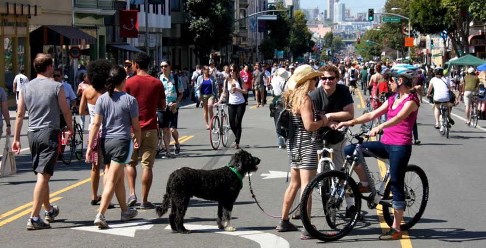
Sunday Streets on Valencia Street in the Mission
Sunday Streets
Sunday Streets celebrated its eighth season with eight monthly events in neighborhoods across San Francisco. Sunday Streets has grown into one of San Francisco’s most popular recreation programs, and this year deepened partnerships with communities, including Excelsior Art Walk and Excelsior Festival, Tenderloin community groups, and in other neighborhoods throughout the city.
Looking ahead, Sunday Streets is planning another eight events for 2016. We are working with SFMTA to make it easier to organize and permit neighborhood play streets events, and beginning planning for weekly car-free space in more parts of the city.
Affordable Housing
Housing affordability remains one of the City’s greatest challenges. Two years ago we published our action plan for housing, 23 recommendations for making San Francisco more affordable while keeping our city livable and green. 2014 saw many successes, with even more in 2015.
Affordable Housing Bond. San Francisco passed its first ever Affordable Housing Bond in November, investing $300 million towards preserving and building affordable housing.
Protecting Existing Housing. Livable City helped author new protections for housing units originally built without permits. These reforms, recently endorsed by the Planning Commission, will help protect an estimated 20-30,000 housing units built since 1960, most of which are rent-controlled.
New Accessory Dwelling Units (ADU). Adding new units in existing buildings is a smart and a green way to add housing in established neighborhoods. Livable City supported planning changes that permit new units in existing buildings in Supervisorial districts 3 and 8. The Planning Department estimates that these measures will create 2,500 new rent-controlled units, and as many as 10,000 if more eligible buildings add units.
Surplus land for affordable housing. Livable City supported the reuse of city-owned parking lots and former freeway parcels in Hayes Valley, SoMa, the Northeast Waterfront, Transbay, Laurel Heights, the Mission, and the Castro for affordable housing. We endorsed a ballot measure prioritizing use of vacant and underutilized city land for housing, which was approved by the voters in November.
Looking ahead, we’re advocating for the City to create its first-ever affordable housing plan, to help ensure that the City’s big commitments of land and funds are used effectively and wisely. We’ll work towards legalizing accessory units in more transit-rich neighborhoods, and lowering parking requirements to increase affordability and reduce traffic. We’ll work to expand protections for rental housing and the San Franciscans who live in them to include units originally built without permits.
Sustainable Transportation
Transit Priority. The approval of last year’s transportation bond helped kick-start transit-priority projects on several of Muni’s most used routes in 2015. Transit priority projects were approved for Market Street, Haight Street, McAllister Street, Fulton Street, and Ocean Avenue. Thanks to the increased funding and advocacy from Livable City and other advocates and neighbors, more of Muni’s transit priority projects includes pedestrian and streetscape improvements, like curb extensions at street corners, moving towards a complete streets strategy that emphasizes safety, walkability, bikeability, greening alongside transit access.
Caltrain. In June, Livable City joined with other advocates to rally for complete funding for Caltrain’s Downtown Extension to the Transbay Transit Center. The idea of removing the northern stub of I-280 gained traction as the Planning Department hired a project manager to advance the proposal. Removing I-280 will allow Caltrain to run underground north of Cesar Chavez street, re-knit the street network to connect Mission Bay with adjacent neighborhoods, reduce deadly traffic in South of Market neighborhoods, and free acres of land for housing and parks.
Vision Zero. The City completed many of its low-cost projects in 2015, including hundreds of small painted safety zones and alterations to increase visibility. Livable City and our fellow Vision Zero Coalition members will advocate for fast-tracking major projects to create permanent safety improvements in our most dangerous corridors in 2016.
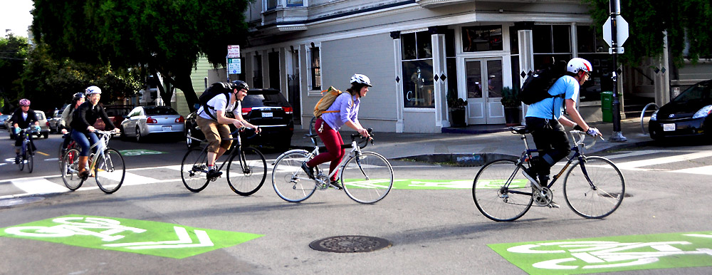
Cycling. San Francisco’s MTA installed its first parking-protected bike lane on Division Street under the Central Freeway, which we will advocate to form the beginning of a citywide network of protected cycle lanes. Approval of a project on The Wiggle is the modest beginning of a bicycle boulevard network for the city. The Metropolitan Transportation Commission funded a major expansion of Bay Area Bike Share, which will begin expanding into more San Francisco neighborhoods in 2016.
The Wiggle offers a relatively flat route between Duboce Park and the Panhandle, enabling bicyclists to avoid some of San Francisco’s notorious hills. Photo by the SF Bicycle Coalition.
Looking ahead, we’re pushing for complete streets – transit, walking, cycling, and greening – on Market, Mission, Geary, Stockton, Van Ness, Third, Fourth, Folsom, Howard, Polk, and the Wiggle. We’ll actively support expansion of Bike Share to other neighborhoods. You can find us working to ensure that updates to the Regional Transportation Plan and Countywide Transportation Plan strengthen sustainable transportation, equity, and smart land use. We’ll speak up for Caltrain modernization, incluing electrification, a new train control system, the Downtown extension, and new or improved neighborhood rail stations in the Bayview, Mission Bay, and Bayshore. To improve mobility and reduce traffic congestion and pollution, we’re building on our successful efforts for further reform of the city’s parking requirements, better management of curb parking and loading, and strengthening incentives for walking, cycling, and transit.
Livable Neighborhoods
In 2015, Livable City worked to secure more public benefits from development. We supported expanding development impact fees to include market-rate housing, and ensure that development fees support walking, cycling, and regional transit. We also helped make sure that large projects provide public benefits and reduce traffic and safety impacts on neighborhoods. For the massive 5M project, we worked the SF Bicycle Coalition and Walk SF to ensure that the project improve safety for walkers and cyclists on surrounding streets, provide public open spaces, and reduce its traffic impact on the surrounding neighborhood.
Looking ahead, we will revive neighborhood planning in San Francisco, increase city funding and maintenance for street trees, reduce flood hazards by integrating greening and permeability into streets and sidewalks, and simplify and modernize the City’s jumbled Planning Code.
Greenway Network
Ten years ago, Livable City launched its greenway network proposal, which envisioned an interconnected network of green streets and parks across the city, supporting active transportation, recreation, and nature.
In 2015, we saw progress in connecting green spaces in the San Miguel Hills, San Francisco’s central mountain range which includes Twin Peaks, Mt. Sutro, Mt. Davidson, Buena Vista, Sunset Heights, and Glen Park. We argued for trail access through the Sutro Tower property as a condition of approving more antennas on the tower. We helped get the San Miguel Hills named a Priority Conservation Area. We worked with city agencies and open space and transportation advocatest on a plan for closing the east side of the figure-8 road atop Twin Peaks to create a bicycle and pedestrian path and viewing area. We are advocating for a Clarendon crosswalk to complete a link in the Bay Area Ridge Trail between Twin Peaks and Mt. Sutro.
On the City’s waterfront, we supported plans for cycle paths on The Embarcadero and Marina Boulevard, and proposed better pedestrian crossings along and across The Embarcadero.
Looking ahead, we will speak up for new and improved waterfront open spaces as part of the Watefront Plan update, and better walking, cycling, and transit access. We’ll work to expand trail and open space connections in the San Miguel Hills, and improve walking and cycling access and road safety in Golden Gate Park and along the city’s Bay shore and Ocean edge.
In 2016, you will see Livable City help create San Francisco’s first affordable housing strategy, and continue to preserve and build the housing our city needs. We will foster the ongoing shift toward sustainable transportation by making the city more bikeable and walkable, and improve transit. We will revive comprehensive neighborhood planning, combining land use, transportation, streets, and public space. Let’s toast to a more livable San Francisco in 2016!
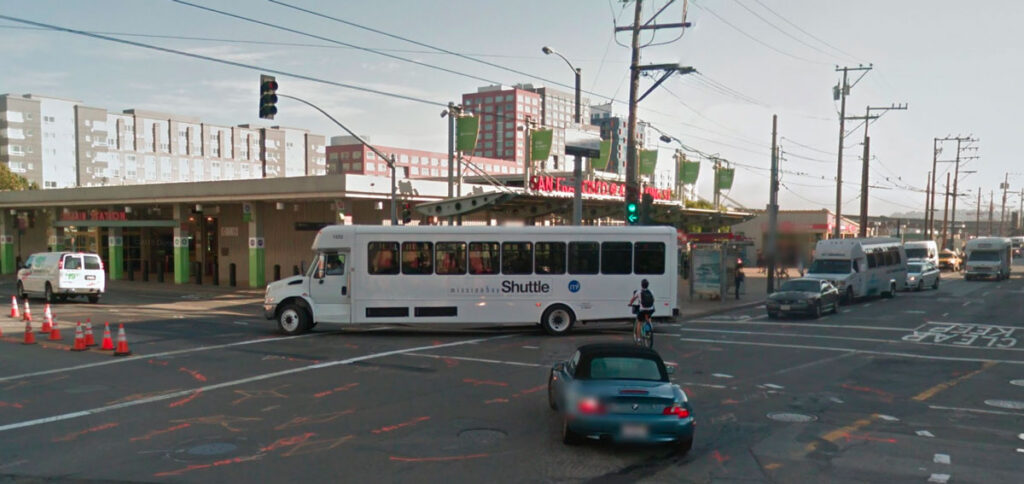
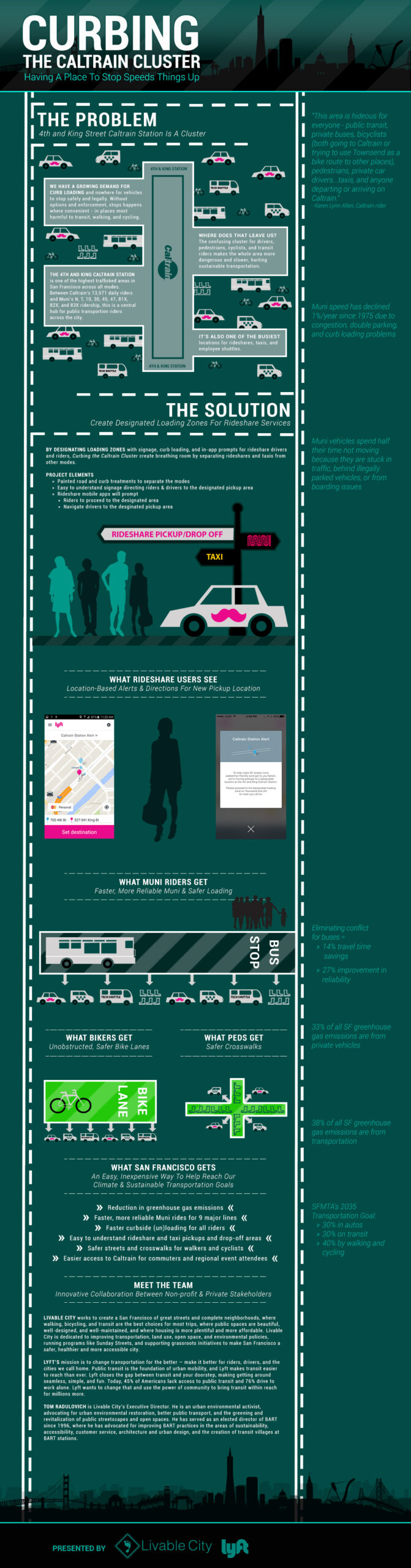
Livable City is proud to announce it is a recipient of the Just Transit SF grant. The grant was administered by the 11th Hour Project, a program of the Schmidt Family Foundation. Livable City, in partnership with Lyft, and in coordination with SFMTA, Caltrain, and other agencies and stakeholders, will immediately begin work to reduce the dangerous congestion at San Francisco’s Caltrain Depot.
The CalTrain Depot at 4th & King Streets
Livable City and Lyft are partnering to streamline multiple modes of transportation at the Caltrain depot by designating loading zones with signage, curb loading markings, and in-app prompts for taxi and rideshare riders and drivers.“Livable City is thrilled to lead this project, which will have an immediate, positive impact on all users near the Caltrain depot,” says Executive Director Tom Radulovich. “By focusing on low-cost design changes, we’ll make the area safer and faster for Muni riders, walkers and cyclists, and taxis, rideshares, and employee shuttles.”
Sunday Streets, a program of Livable City, is San Francisco’s pre-eminent program reclaiming streets as community public spaces.
The Stormwater Design Guidelines, published by the San Francisco PUC, include design standards, plant selections, and application materials for creating green stormwater infrastructure, including permeable pavement, sidewalk plantings, and rain gardens.
Plant SF provides both inspiration and how-to advice on sidewalk landscaping in San Francisco.
Pavement to Parks is a project of San Francisco’s Planning Department that works with neighborhoods to create and tests their ideas for new public spaces, including parklets.
Street Parks is a joint project of the San Francisco Parks Alliance and Department of Public Works to help neighbors transform street rights-of-way into public open spaces.
The Market Octavia Living Alleys Program is a two-year community-based program to design and implement a network of Living Alleys in the Market & Octavia Plan area.
Mint Plaza is a public street reclaimed as a public plaza near the Old Mint in Downtown San Francisco.
Annie Street Plaza is an alleyway in Downtown SF reclaimed as a public plaza by the Yerba Buena CBD.
Linden Living Alley is a Living Alley in San Francisco’s Hayes Valley, which won Livable City’s award for innovation.
The Living Alleys Toolkit is a how-to guide and pattern book for creating living alleys in San Francisco.
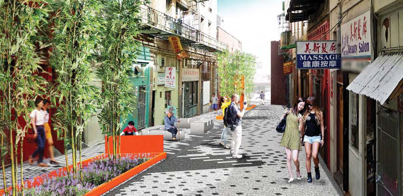
The Chinatown Alleyway Renovation Program is a partnership between CCDC and the Department of Public Works to transform Chinatown Alleyways into people-oriented public spaces.
A rendering from the Chinatown Green Alley project featuring innovative green infrastructure technologies.
National and International
Project for Public Spaces is a nonprofit organization dedicated to creating and sustaining public places that build communities.
City Repair offers photos and notes from a street reclaiming project in Portland, OR.
Gehl Architects ‘urban quality consultants’ based in Copenhagen, led by urbanist Jan Gehl.
Urb-i provides ideas and inspiration for better cities, including galleries showing hundreds of before-and-after images of street reclaiming.
NACTO (the National Association of City Transportation Officials) is a national association dedicated to promoting more people-oriented street design. NACTO’s street design standards have been adopted in a growing number of cities, including San Francisco.
The World Carfree Network is a clearinghouse of information from around the world on how to revitalize our towns and cities by creating car-free spaces.
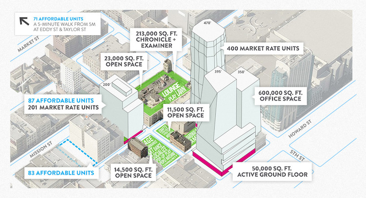
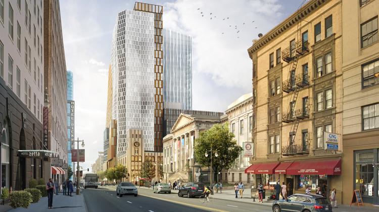
Two big private developments won important approvals in the last month – one from the voters, and the other from the Board of Supervisors. Voters approved Proposition D, approving a height limit increase for the Mission Rock Development on San Francisco’s waterfront, as well as a host of policies related to the development. The Board of Supervisors approved the 5M project, which will occupy the Chronicle Building and several adjacent buildings and parking lots at Fifth and Mission streets.
Mission Rock will occupy a large public trust property, zoned over two decades ago for open space, but leased since then by the Port to the Giants for a stadium parking lot. 5M includes portions of five city blocks, including parking lots and historic buildings. Both projects are radically larger than what the zoning for their sites permitted. Both had politically-connected development teams, including the Hearst media conglomerate and the San Francisco Giants baseball franchise. Each cited a years-long planning and development approval process to legitimize the project, and the exceptions they sought. Both promised big public benefits – open space, and that 40% of the housing they build will be permanently affordable (some of 5M’s affordable units will be off-site in separate projects).
Large projects like these have the potential to transform neglected areas in the city into livable urban neighborhoods, providing needed housing and work spaces while embracing sustainable transportation and building practices, affordability, complete streets, and green public places. 5M and Mission Rock will realize some of that potential, but so far have also fallen short in important ways, especially in transportation. Both projects demonstrated San Francisco’s lack of a cohesive sustainable development strategy, and the limitations of the City’s practice of planning-by-exception.
Incorporating Sustainable Transportation into Big Builds
Good planning creates projects that enhance sustainable transportation access and safety – walking, cycling, and public transit – for the benefit of the project and the neighborhood. Some transportation improvements can be planned and built at a project scale. Others, like transit capacity or bicycle networks, must be planned at a neighborhood or system level.
Both 5M and Mission Rock missed important opportunities to improve local transportation, and to embrace sustainable transportation strategies that reduce or mitigate the impact of auto traffic.
5M: Mega Development in a Mega Transportation Hub
5M is bounded by Mission, 5th, Howard, and 6th streets. Mission, Howard, and 6th are high-injury corridors – the 5% of San Francisco streets where over half of pedestrian deaths and serious injuries occur. Major transit lines run down Mission, and these must already navigate heavy traffic and large garages like that at 5th and Mission. Howard, one block away, is SoMa’s best westbound bicycle route. Fifth Street is part of the City’s bicycle network and is also a heavily-used transit corridor. 5M proposed some modest access improvements – wider sidewalks in places, and a new crosswalk to Mint Plaza. However, new loading zones and garage entrances on both 5th and Howard compromise bicycle safety on these important bike routes, and the added danger to pedestrians from additional traffic and right-turning vehicles is mostly unmitigated.
Livable City worked with other advocates, including Walk San Francisco and the San Francisco Bicycle Coalition, to insist that 5M reduce the amount of commuter and residential parking in the project, and thereby to reduce the traffic burden on adjacent streets. Last month 5M agreed to reduce parking in the project. Although 6th Street has a plan to improve pedestrian safety and provide cycle lanes, 5th, Mission, and Howard do not. In response, we met with the developers and SFMTA to outline a planning study for these streets to make walking and cycling safer, and to better accommodate local transit.
Mission Rock: Too Much Parking in an Over-parked Neighborhood
Notice anything missing from this picture or the campaign literature you likely received? Parking, and lots of it. Prop D proposed the Mission Rock development add over 3,000 parking spaces, including 2,300 in a 10-story parking garage occupying a full city block. This was proposed despite the fact that over 9,000 parking spots already exist within walking distance of the project. Most of these spaces go unused on evenings and weekends. Moreover, the neighborhood is served by Caltrain, the K-T and N Muni lines, and and bus rapid transit is planned for 16th Street.
The common refrain is that we need tens of thousands of parking spaces to accommodate the UCSF’s campus, the Warriors arena, and AT&T Park’s crowds. None of these developments, however, are heavily used 24 hours a day, every day. A neighborhood parking plan, together with improved walking, cycling, and transit access, would accommodate all the reasonable parking needs of Mission Rock development and the proposed Golden State Warriors arena without building more parking in Mission Bay. But the City doesn’t have a plan.
It’s possible that after environmental review and project approvals, the Board of Supervisors may realize that the transportation policies in Proposition D, especially those calling for massive parking structures, are bad for the neighborhood, nearby neighborhoods, and the environment. They may decide that housing and parks are a better use for waterfront public land in an increasingly crowded City.
Livable City has helped shape many neighborhood plans citywide, and we think it’s time to refresh the plan for Mission Bay. We will advocate for a parking and transportation strategy for the whole Mission Bay, since the current plan is almost two decades old. The uses currently proposed in the neighborhood – high-rise development on the Mission Rock site, a basketball arena, and office projects like the proposed Uber headquarters – are very different, and much more intensive, than what was originally studied.
Planning for Livable Neighborhoods
Both 5M and Mission Rock are located in parts of the city that have been the subject of multiple neighborhood plans. Yet in both cases, the projects are very different from what those plans call for. In neither instance was there an implementable plan for street design, or for sustainable transportation. The transportation shortcomings in these two projects point to big flaws in the way the City plans major projects.
5M is within the Planning Department’s Central SoMa Plan area, but the site was carved out and planning for it led by a separate agency, the Mayor’s Office of Economic and Workforce Development. The Central SoMa plan includes street plans for Folsom and Howard, but not 5th. In 2013, Livable City requested that a 5th Street plan be included in Central SoMa, but Planning refused. Planning for 5th Street improvements was promised in 2009 as part of the Market Street Place project approval, but the City has yet to collect the funds or start the plan. 5th Street is the eastern edge of the Eastern SoMa Plan, adopted in 2008, but that plan also neglected 5th Street. The Environmental Impact Report for 5M barely touched pedestrian safety, and didn’t address bicycle safety or access on 5th and Howard. Safety and access would be severely compromised if the development moved forward as planned. Last month, 5M agreed to fund a 5th Street study, which will finally bring 5th Street the attention it deserves.
The planning around Mission Rock is similarly fragmented. The project is on waterfront public land, within the jurisdiction of the Port of San Francisco, but the Planning Department also has land use authority. It is bounded on the west and south by the Mission Bay Redevelopment Area, which is governed by the Office of Community Infrastructure and Investment (OCII – formerly the San Francisco Redevelopment Agency). Planning, the Port, and OCII are overseen by separate commissions, with different policies and priorities around transportation, land use, and urban design. The Environmental Impact Report for Mission Rock is not complete, but, like 5M, it is taking a disconnected view of the project and its transportation needs and impacts, rather than planning Mission Rock and the proposed Golden State Warriors arena next door in the context of Mission Bay as a whole.
Downtown, SoMa, and Mission Bay will add thousands of new residents and new jobs in coming years. 5M and Mission Rock demonstrate how San Francisco’s piecemeal, fragmented, and reactive planning, especially transportation planning, require thorough reform. We need to update neighborhood plans – especially the Downtown Plan, the various SoMa plans, and Mission Bay Plan, to include complete streets, bicycle and pedestrian safety, and strategies to reduce auto traffic and congestion. Environmental review, as San Francisco currently practices it, is an expensive and time-consuming exercise that has repeatedly proven useless for improving pedestrian and bicycle safety, or devising sustainable transportation strategies for neighborhoods and projects.
The city needs to stop working in silos – neglecting the street or building next door – simply because it is outside the immediate project area. By creating or updating neighborhood plans, we can build neighborhoods with unique identities that still allow for growth, safe places for transit, cyclists and pedestrians, and open space. We continue to work with government and private partners to make good projects great for all citizens. As we move into 2016, Livable City will advocate for the City to renew these plans to ensure every neighborhood has a plan for the future.
City Streets comprise 25% of San Francisco’s land area. Most of San Francisco’s street area is used for the movement and storage of private autos, but there is a growing movement to unlock City streets’ potential as temporary and permanent spaces for active transportation, meeting, play, community, greenery, nature, and managing urban waters. This moderated discussion features the region’s foremost leaders in imaginative street and public space design. Together, we will explore the ways San Franciscans are already reclaiming city streets, and the landscape of opportunities that lie ahead.
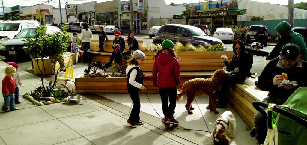
Parklet at 3876 Noriega Street. Photo by the San Francisco Planning Department
Please join us for Tomorrow Transit: Reshaping the Urban Landscape on December 10 from 6:00-8:00 p.m. at the Women’s Building. This free discussion explores the future of our streets and public spaces.
Meet Our Panelists:
Adam Greenfield is a San Francisco-based public space advocate and community organizer. He is founder of Streets For All, an initiative to make San Francisco the block party capital of the United States, which has lead to almost 40 community street events since 2009. Adam is also co-founder and Chair of the Inner Sunset Sundays events, a leading model in San Francisco for how communities can regularly reclaim streets for socializing, play, culture, and general enjoyment. His other projects include Built Curious, a walking experience that raises awareness of urban design principles, and The Public Bench Project, a grassroots initiative to build community through benches. Currently, he is collaborating on a project to create inspiring images of San Francisco’s streets reimagined as civic gathering spaces.
Allan Jacobs is a consultant in city planning and urban design. He twice chaired UC Berkeley’s Department of City and Regional Planning, where he taught for nearly 30 years, along with University of Pennsylvania and University College London. Allan is the former Director of the San Francisco Department of City Planning, author of San Francisco’s Urban Design Plan, and several books, including the forthcoming The Good City: Reflections and Imaginations, Great Streets, Looking at Cities, and Making City Planning Work.
Rosey Jencks leads the Urban Watershed Management Program at the San Francisco Public Utilities Commission where she integrates stormwater management and other water sensitive polices and designs into San Francisco’s landscape. She is currently project manager for the Urban Watershed Assessment a citywide planning effort to identify green and grey infrastructure solutions for the next 20 years and is the technical lead on the SFPUC’s Civic Center Sustainable Utility District. Rosey has a master’s degree in Landscape Architecture and Environmental Planning from UC Berkeley. She has worked as a planning consultant to local governments and in public policy and environmental nonprofits. She was a co-founder of the San Francisco Green Schoolyard Alliance and has focused on urban greening in all her work.
Elizabeth Macdonald is Associate Professor of Urban Design at UC Berkeley’s Departments of City and Regional Planning and Landscape Architecture/Environmental Planning. Her research focuses on the history of urban form, street design, and the post-occupancy assessment of streets and neighborhoods shaped by planning and urban design policy. She is also a partner in the San Francisco-based urban design firm, Jacobs Macdonald: Cityworks. She consults internationally on street design and planning projects and has designed multiway boulevards in San Francisco, Vancouver, British Columbia, and Ahmedabad, India. Elizabeth has authored Pleasure Drives and Promenades: A History of Frederick Law Olmsted’s Brooklyn Parkways, The Boulevard Book: History, Evolution, Design of Multiway Boulevards, The Urban Design Reader.
Blaine Merker is an Urban Designer inspired by the challenge of making cities that support human happiness, equity, health and connectedness. As Head of Team at Gehl Studio San Francisco, he directs fine-grained, catalytic projects that steer cities and organizations towards sustainability, creativity and long-term value creation. Blaine is a seasoned listener and facilitator, engaging communities, governments, developers, academics and cultural institutions in cross-disciplinary collaboration. He comes to Gehl from leading Rebar Art and Design Studio and is a lecturer at the University of California Berkeley College of Environmental Design, where he earned his masters degree.
Livable City’s recommendations for San Francisco’s November 3, 2015 election
Yes on Prop A, Affordable Housing Bond No on Prop D, Mission Rock Development
Yes on Prop F, Short-term rental regulation No on G/Yes on H, Clean energy Yes on Prop J, Legacy Business fund Yes on Prop K, Surplus land for Affordable Housing
Yes on A – Affordable Housing Bond
San Francisco is in a housing affordability crisis. Proposition A will invest $300 million to build and rebuild permanently affordable housing for San Franciscans at a range of incomes.
No on D – Mission Rock Development
The Mission Rock development site encompasses two parcels on San Francisco’s waterfront – Pier 48, an historic pier building, and Seawall Lot 337, bounded by China Basin, 3rd Street, Terry Francois Boulevard, and Mission Rock Street. These lots, and the adjacent public streets, are public trust lands, held in trust for the benefit of all the people of the State, with the Port of San Francisco as trustee. The 1990 Mission Bay Plan designated Seawall Lot 337 as an open space. It is zoned Mission Bay-Open Space (MB-OS) but the park was never built. After 2000 it was leased to the Giants for use as stadium parking. Several years ago the Port signed an exclusive negotiating agreement for development of the site with a development consortium led by the Giants. In June 2014, San Francisco voters approved Proposition B, which requires voter approval to increase the allowable building height on lands in Port jurisdiction. Reuse of Pier 48 is unaffected by Prop B, because it is an existing building in a 40′ height district, but development on Seawall Lot 337, which is zoned for open space, requires voter approval.
Proposition D, authored by the Mission Rock developers, authorizes height increases on Seawall Lot 337, designating a portion, mostly at the north end of the site near China Basin, as open space, creating a pattern of internal streets, and rezoning the rest to allow buildings from 40′ to 190′ in height.
Proposition D also contains various policies which go far beyond permitting height increases. These include:
33% of the housing built should be affordable to households earning up to 140% of median income
The development will include 2300 parking spaces in a new above-ground parking structure, and approximately 800 additional parking spaces.
parking taxes collected on the site, which currently fund Muni operations, would instead be used to pay for transportation improvements specific to the development.
property taxes and jobs-housing linkage fees would also be used by the developer to fund open space and affordable housing on the development site.
After the ballot measure was filed by the developers, Supervisor Jane Kim negotiated a separate agreement with the developer that 40%, rather than 33%, of housing on site would be permanently affordable.
The right combination of open space and mixed-use development, oriented to transit and with a large component of affordable housing, could be a wise use for these public trust lands. However Proposition D falls short, and several of its major provisions led us to recommend a ‘no’ vote:
Ballot box planning. This measure furthers a recent trend towards large projects writing their own rules. Voter approval of height changes is now required, but Prop D goes much further, bundling in voter endorsement of controversial project elements, like the number of parking spaces and uses of public funds, that should be decided through an open and participatory planning process.
Parking and congestion. Mission Bay is already over-parked, and the 2300 parking spaces called for in this project will worsen traffic congestion, pollution, and traffic danger in the neighborhood. Because of its location on landfill, most of Mission Bay’s parking is in freestanding structures, which dominate portions of the neighborhood and its streets. The Warriors arena EIR reveals that over 9000 non-residential spaces already exist in Mission Bay, and most of these are used only during the weekday. If managed intelligently, that parking could also accommodate any reasonable parking needs that the Giants’ and Warriors’ stadiums may have, and new parking structures are unnecessary.
Freestanding parking structure. This project proposes a 10-story freestanding parking structure on public trust land, occupying an entire city block. Waterfront public trust lands are a scarce resource, and freestanding parking structures are a poor use for waterfront lands. Prop D specifies a new aboveground structure, and does not require that it be wrapped in active street-facing uses as generally required by the Planning Code.
Diversion of citywide taxes and fees to fund a private development project. The policies in Prop D direct the city to divert Jobs-Housing Linkage Fees, Infrastructure Finance District (property tax) revenues, and Parking Tax revenues to the project, rather than fund citywide operating and capital needs. This will set a bad precedent for other private projects, and the Warriors arena project is already trying to copy the precedent.
Yes on F – Short-term rental regulation
Short-term rentals through firms like Airbnb have burgeoned in recent years, and without proper regulation could convert thousands of homes and apartments, including many rent-stabilized units, from permanent housing for residents into hotels. The best way to regulate a fast-growing, and fast-changing industry like short-term rentals is through the legislative process, not at the Ballot box. Late in 2014, the Board of Supervisors approved the first comprehensive short-term rental regulation. However, before the administration of that legislation could be set up, the Board voted in June of 2015 to weaken it. Faced with the unappealing dilemma of regulation at the ballot box or weakened legislation, we chose to support Proposition F. It will permit short-term rentals of dwellings up to 75 nights each year, with robust provisions for registration and enforcement.
No on G, Yes on H – Clean energy
San Francisco has been slowly moving towards Community Choice Aggregation (CCA), which will allow the City to broker energy from various providers and offer it to San Franciscans. San Francisco’s program, called Clean Power SF, aims to replace fossil fuel and nuclear power with renewable energy sources to the extent possible, and is an important element of San Francisco’s climate protection strategy. Under Clean Power SF, PG&E would distribute and meter power through its network, but would lose its local monopoly as a power provider.
Proposition G, placed on the ballot by IBEW Local 6, was intended to disadvantage Clean Power SF relative to PG&E. The Board of Supervisors worked with clean power advocates and IBEW on a consensus measure, Proposition H, which sets a goal of 100% clean and renewable power for the Clean Power SF program, and requires reporting on energy sources consistent with the State’s renewable energy standards. IBEW has joined clean power advocates in opposing Proposition G and endorsing Proposition H. When two measures dealing with the same topic appear on the same ballot and both measures pass, the one recieving the most votes prevails.
Yes on J – Legacy Business Fund
Proposition J authorizes a loan fund to support long-term leases for legacy San Francisco businesses, protecting such businesses from displacement in neighborhoods with surging rents, and providing them with capital to make necessary upgrades to their facilities. Legacy Businesses are defined as local businesses that have been continuous operation for two decades. The measure authorizes the City’s Office of Small Business to administer the loan fund and establish criteria. The measure does not set aside funding, leaving it to the Board of Supervisors to decide how much to fund the program through the City budget process, or through grants. As the City grows and changes, Prop J will help stabilize local businesses and preserve the jobs they support.
Yes on K – Surplus Land for Affordable Housing
Current City and State policy requires that surplus public land be made available first to other government agencies, and then for affordable housing. Proposition K will create a procedure within the Mayor’s Office of Housing and Community Development to catalog and document surplus and underutilized public properties in San Francisco, assess them for their suitablity for affordable housing, and recommend to the Board of Supervisors how they should be used. In a compact city, publicly-owned land is a key resource to enhance affordability, and Proposition K will create rigor and clarity around the city’s priorities for vacant and underutilized land, which to date has been a haphazard process.
The Transbay Transit Center project, along with Caltrain’s planned modernization, promises to be one of the most transformative infrastructure projects for San Francisco and the region in both the near term and for years to come.
Phase One of the Transbay Transit Center project is scheduled to open in 2017. It includes an elevated regional bus terminal, connected to via dedicated bus ramps to the Bay Bridge. The new bus terminal will allow AC Transit to greatly expand its Transbay bus service. This couldn’t come soon enough, as BART’s Embarcadero and Montgomery stations are nearing their designed capacity during rush hour, and more Transbay transit capacity is urgently needed. Projects like dedicated bus lanes on the Bay Bridge and on the East Bay’s freeways and streets can make expanded Transbay bus service faster and more reliable. The first phase of Transbay will also complete an underground train station box, designed to accommodate six tracks and their platforms.
Phase Two of the Transbay project will extend the Caltrain line from its current terminus at 4th and King to the new Transbay rail station. Together with Caltrain Electrification and Caltrain’s purchase of new train sets, both currently in the beginning stages, Phase Two will allow electrified Caltrain and future High Speed Rail service to extend Downtown, connecting to Downtown jobs and regional transit on and under Market and Mission streets. This project will finally close the biggest gap in the regional transit network, connecting the region’s two largest Downtowns directly to one another, and to two regional airports and numerous smaller downtowns in between.
California High Speed Rail and Caltrain adopted a blended system strategy on the Peninsula, where Caltrain and High Speed Rail would share tracks and stations, with passing tracks added in key locations to allow express and high-speed trains to pass local trains. Blended service means transforming Caltrain from a mid-20th-Century diesel commuter service to a 21st-century regional metro service. A project to upgrade Caltrain’s signaling system is currently underway. Electrification of the line is scheduled for completion in 2020. Caltrain will replace its current diesel-locomotive-hauled trainsets with electric multiple unit trainsets by 2020. Other integration projects include level boarding platforms for greater accessibility, and full grade separation of the lines to increase speed and safety and eliminate traffic conflicts.
A New Downtown neighborhood at Transbay
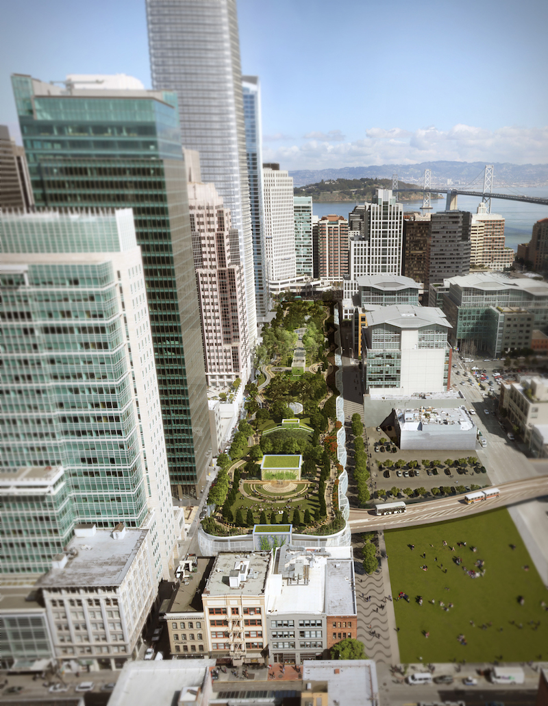
The removal of the Embarcadero Freeway and its tangle of ramps just south of the Transbay Transit Center freed several acres of land to create a new neighborhood. The Transit Center District Plan, completed in 2012, is the blueprint for a high-rise transit-oriented neighborhood surrounding the Transbay Terminal, with thousands of new jobs and new residents. Salesforce Tower, under construction next to the transit center, will, at over 1000 feet, be San Francisco’s tallest building. A condition of the land transfer from the State to the City is that 35% of the new housing built on former freeway land must be permanently affordable to low and moderate-income households.
Regional Metro service for San Francisco and the Peninsula
Electrification of Caltrain, together with passing tracks and grade separation, will enable a robust regional metro service for eastern San Francisco, in addition to high-speed and Peninsula commute service. It would be San Francisco’s first new metro line since BART service opened in 1973 and later extended to SFO and Millbrae. Much development is planned or under construction in the neighborhoods along the Caltrain line, and a high-capacity, fast, and frequent rail service connecting these neighborhoods to both Downtown and Silicon Valley can help San Francisco develop in a much more transit-oriented manner.
Adding or relocating Caltrain stations can better connect Caltrain to adjacent communities and to Muni’s local transit network. The decision decades ago to build BART’s Glen Park, Balboa Park, and Daly City stations alongside freeways demonstrates how entangling stations in freeway ramps and locating them next to uses like maintenance shops can limit safe walking, cycling, and transit access to stations, and compromise the development of livable neighborhoods centered around them. Four decades after BART opened, San Francisco is taking tentative steps to better connect these stations to the surrounding communities, and foster the development of neighborhood centers around them. Fortunately it looks as though San Francisco may learn from the BART experience as it looks to stations along the Caltrain line, with three Caltrain station studies underway.
In the vicinity of Mission Bay, The Railyard-Boulevard Study will examine options for putting the Caltrain line underground, either on its existing alignment or on a new alignment through Mission Bay. It will also look at removing the northern portion of I-280, and replacing it with a system of surface roadways to knit the Mission Bay development into adjacent SoMa and Showplace Square-Potrero neighborhoods. Removal of I-280 also allows for the creation of a vibrant new neighborhood, as freeway removal did at Transbay and in Hayes Valley.
The Bayshore Multi-Modal Facility Study is examining how to connect Caltrain to San Francisco’s transit network in Visitacion Valley. One option is to move the Bayshore Caltrain station a few blocks north to create a closer connection to the T-3rd line and future bus service to Candlestick Point. The project had an open house in early October, and will present plans to the community in 2016. Extending the T-3rd out Geneva Avenue to the multimodal transit hub at Balboa Park Station is a promising idea, one that creates operational flexibility for Muni (linking Muni’s two rail maintenance facilities directly to one another) and providing a needed transit upgrade in a corridor with some large development projects, including Sunnydale and Cow Palace, that could be more transit-oriented.
The Caltrain Oakdale Station Study found that a new Caltrain station at Oakdale Street, close to the Bayview’s commercial and cultural heart near 3rd and Oakdale, is feasible, and also makes connections between Caltrain and Muni’s crosstown 24 and 44 routes.
A Second Bay Crossing
Transbay’s rail station is being built so it can be extended under Beale Street, and could continue east under the bay to provide a second rail crossing under San Francisco Bay. Such a crossing could serve Alameda Point, a former naval base now being redeveloped as a mixed-use neighborhood, and continue into Oakland. A connection to the Capitol Corridor line would connect inner-East Bay neighborhoods like Emeryville and West Berkeley, and Richmond, Martinez, Solano County, and the Sacramento region, to Downtown San Francisco. A through-running terminal at Transbay would increase its rail throughput, as would facilities like yards and rail storage tracks in the East Bay. Upgrades to the Capitol Corridor could open the possibility of high-speed service between San Francisco, Oakland, and Sacramento.
The Future of Downtown Forum
You can learn more about the future of Transbay and downtown this Thursday, October 15 at the San Francisco Public Library’s Koret Auditorium from 6:00-7:30 p.m. 2015 is the 30th anniversary of the Downtown Plan. Our City is vastly different than it was in 1985, but our plan for the downtown community remains a generation behind. Join us and panelists Maria Ayerdi-Kaplan, Executive Director of the Transbay Joint Powers Authority, Kevin Conger, founding partner of CMG Landscape Architecture, and Joshua Switzky, Manager of Community Planning in the Citywide Planning Division of the San Francisco Planning Department to discuss the future of this urban landscape, how we move people from point A to point B, and its increasing role as a central social district. This is a rare opportunity to take a critical look at San Francisco’s downtown and how it can be shaped into a cohesive and thriving economic, social, and residential neighborhood.
San Francisco’s Downtown Plan turned 30 this year. The plan came about in the midst of the 1980s “Planning Wars,” when battles over density, building height, and office uses were fought in City Hall and the ballot box.
The Downtown Plan attempted two reconcile two contending visions of the city – that of postwar Modernism, which had transformed much of San Francisco with steel and glass high rises, freeways, parking structures, and large-scale urban renewal projects which bulldozed entire neighborhoods, and that of traditional urbanism, based on human-scaled buildings, walkability, small blocks, and a fine-grained mix of land uses.
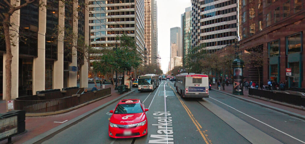
Market Street, Downtown, San Francisco
When the plan was adopted, it won considerable praise for its integrated approach. Architecture theorist and critic Charles Jencks wrote:
It’s virtually the most comprehensive urban development plan ever conceived in the United States. Fundamentally it entails that office development be cut down in size and shape to smaller, thinner towers that prevailed in the International Style blocks of the 1960s, and that speculators will put aside part of their investment to pay for public open space, works of art and public transport . . . Older buildings and districts are to be preserved, mixed use incorporated, housing for secretaries, janitors, and executives provided (those who work in the new office space), one percent of the budget made over to public art works, money put aside for child-care funds and five dollars per square foot of new construction put towards the cost of public transport. In effect Dean Macris [then Planning Director] has managed to pass legation that favors the public over the private realm, and communal open space over the automobile. In America this reversal of prevailing values is unique, at least on such a scale.”
Some of the provisions of the plan praised by Jencks and others were part of Proposition M, a voter-approved measure that passed in November 1986. The adoption of the Downtown Plan, and the passage of Proposition M the following year, have provided the planning framework for Downtown’s growth over the subsequent decades. The Transit Center District Plan, which was approved in 2012, built on the guiding principles of the Downtown Plan – it permits taller towers, but kept the requirements for spacing and tapering to permit sunlight and reduce ground-level winds, further reduced allowable office parking to reduce auto congestion and encourage sustainable transportation, and strengthened the requirements for streetscape improvements and transit funding from new development.
The Downtown Plan built on regional transit investments made in the 1970s, including BART and the Muni Metro underground, and on San Francisco’s Transit First Policy, first adopted in 1973, the year that BART opened in Downtown San Francisco. The plan clustered new office development along Market Street, and set maximum amounts of parking for office and other uses. About 60% of Downtown workers take transit, walk, or bicycle to work, making Downtown San Francisco the most transit-oriented jobs center in the Bay Area, and fourth in the US behind New York, Washington, and Boston.
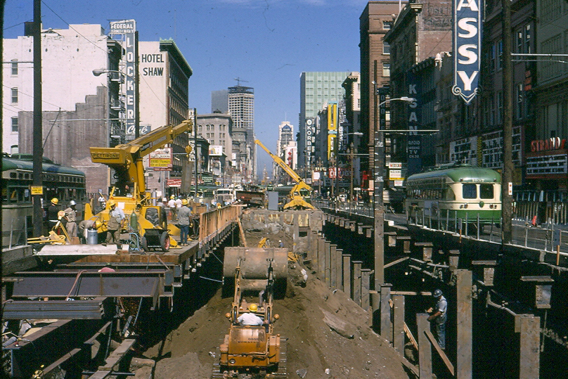
Market & 7th Street during BART construction in the late 1960’s
However, recent years have also seen a resurgence of what John Parman calls the “sorry tradition of case-by-case rezoning in San Francisco.” An increasing number of projects are being brought forward that flout the Downtown Plan’s policies and standards – the excess parking awarded to the Market Street Place shopping mall, the bulky towers proposed by the 5M project, and Trinity Plaza’s vast gray slabs rather than the tapered towers and active street frontage called for in the Downtown Plan. As former Planning Director Allan Jacobs recently observed, “More and more things are being done by discretion rather than by what the zoning laws say. That is always a mistake because when you do that, the party with the most power always wins. And that party is never the city planner.” Five years ago, the Chronicle’s architecture writer John King called for a revived and refreshed Downtown Plan, and noted the cost of not having one: “As long as downtown is up for grabs, in effect, count on the process to grow more strident and cynical.”
The best way forward for Downtown is in accordance with the rule of law and guided by a Downtown Plan that is comprehensive and strategic yet provides necessary flexibility, rather than a further lapse into the corrupting habit of planning-by-exception. Fortunately we have a strong Downtown Plan to build on, one whose key strategies – a compact Downtown oriented to walking and public transit, a proper balance between public and private, well-designed and dignified streets and public open spaces, housing for residents of diverse incomes – are as timely now as they were three decades ago. In some key areas the Downtown Plan has fallen short of its goals. In some cases, it’s because actual planning and zoning controls are out of step with the Downtown Plan’s policies. In others, the Planning Department, other agencies, and/or elected officials aren’t committed to the policies and implementing actions necessary to realize them.
Central Business District or Central Social District?
Post-World War 2 planning placed great faith in functional zoning – physically separating activities like housing, offices, shops, and industry into distinct zones, to rationalize and simplify the city and to prevent potential conflicts between uses. San Francisco had grown and developed for nearly a century without zoning, and uses were mixed together in that perplexed and dismayed postwar planners. Early zoning schemes relied on a simple three-part zoning scheme, which established R (residential) districts for housing, C (commercial) districts for offices and shops, and M (manufacturing) districts for industry. It was presumed that nonconforming uses – uses that didn’t fit the new zoning – would be phased out over time, and order imposed on the chaos of the city. Downtown became the C-3 (downtown commercial) district, dedicated primarily to offices, and secondarily to retail.
The Downtown Plan retained a focus on Downtown as the City’s, and the Bay Area’s, central business district, but acknowledged and encouraged complementary uses, like retail, hotels, and support services.
The Downtown Plan encouraged ground-floor retail uses by providing a density bonus incentive in the Financial District, and requiring ground-floor retail in the Downtown Retail (C-3-R) sub-area around Union Square. Union Square remains the region’s destination retail center, but retail uses elsewhere in Downtown struggle. Union Square is an established shopping district that is enlivened by its diverse mix of uses – offices and retail, but also hotels, housing, convention center, theaters, and museums. The less diverse parts of downtown, like the Financial District, have retail uses oriented to office workers, but little evening or weekend activity. A more diverse Downtown – more residents, more arts and culture – could support more shops and restaurants. Many Downtown streets are too dominated by auto traffic and poorly-designed buildings to support healthy retail districts, as we discuss below.
Downtown is also home to arts and culture, including the theater district west of Union Square, the museums and theater in Yerba Buena, and galleries, performance spaces, and spaces for artists. Mid-Market, which once was home to many theaters and cinemas, now supports a handful. It has, over the years, been proposed as an arts and theater district. One historic theater, the Strand, was recently restored and reopened by ACT, but another, the St. Francis, was demolished for a shopping mall. Downtown’s zoning provides few incentives for art spaces and doesn’t protect them from conversion, so many art spaces, galleries, and arts and culture nonprofits have been priced out of Downtown or are under threat of displacement.
Affordable Housing
During the urban renewal decades of the 1950s and 60s, San Francisco’s Redevelopment Agency demolished hundreds of affordable apartments and residential hotels in Yerba Buena and Golden Gateway. By the mid-70s Redevelopment had reversed course, and redevelopment projects of the 80s and 90s replaced and rehabilitated housing in Yerba Buena and around 6th Street. The Downtown Plan aimed to preserve existing housing by placing strict limits on residential demolition and conversion.
However the plan didn’t contemplate that much new housing would be built Downtown; instead, it called for protecting existing affordable housing in the adjacent Chinatown and Tenderloin neighborhoods, and building new housing in South of Market, Rincon Hill, and the Van Ness corridor. Supervisor Carole Ruth Silver proposed a middle-income housing zone in Mid-Market in the mid-1980s. The notion was revived two decades later in the Mid-Market Redevelopment plan, which then fizzled. High-rise projects have been built in Downtown, but most are expensive towers without on-site affordable units The Market and Octavia Plan rezoned the area around Van Ness and Market for high rise residential, but little of that will be permanently affordable; few developments meet their affordable housing obligations on-site, or in Downtown. Housing in the Transbay Redevelopment Area, around the new Transbay Transit Center, will be 35% affordable by state law. Affordable housing in and around Downtown remains a compelling need.
Livable City worked with Supervisor Chiu to remove the Conditional Use requirement for dense housing downtown, which added risk and cost to both affordable and market-rate housing projects. We proposed a floor-area-ratio exception for affordable housing as an incentive to build affordable units downtown, which was partially enacted this year. More incentives, as well as direct funding for housing through impact fees and the proposed housing bond, could help create more affordable housing downtown. The City could build affordable housing on the site of some of Downtown’s city-owned parking lots and garages, like the Yerba Buena Garage on 3rd Street.
Reducing the amount of off-street parking in Downtown housing decreases the cost to built and to rent housing, and decreases automobile congestion by encouraging residents to use Downtown’s sustainable transportation options. Livable City helped eliminate Downtown’s minimum parking requirements for housing in 2006, and where parking is provided, the cost of parking must now be unbundled from sale or lease costs. Within the last five years, we helped eliminate minimum parking requirements in the neighborhoods adjacent to Downtown – the Tenderloin, Chinatown, and SoMa.
Sustainable Transportation
Downtown has long been the hub of the region’s public transportation system, and was revitalized by in investments in rail transit. In 1962, the voters approved a bond to build the three-county BART system, and the Muni Metro subway. BART service opened in 1973, and the Muni metro opened in the late 1970s. Today both rail systems face capacity constraints and overcrowding, and need major reinvestment in aging infrastructure.
The 1973 Transit First policy included an action plan for prioritizing transit on city streets. Expanding transit priority – dedicated lanes, bus bulbouts, traffic signal priority, etc. – on the bus and light rail lines serving Downtown are essential to improving the speed, reliability, and accessibility of surface transit, and are the focus of SFMTA’s Transit Effectiveness Project and Muni Forward initiatives.
After the flurry of activity in the 70s, little changed in the subsequent three decades. However recent moves to establish transit priority on Market Street have been modest but effective. Better Market Street could restrict private cars altogether.
The Caltrain line has been in operation for over 150 years, and is the region’s oldest passenger rail service. Extending Caltrain Downtown has been talked about for over a century, and by the end of the decade we will see two significant strides towards that vision. The Transbay Transit Center’s first phase, due to open in 2017, will reopen a needed transbay bus terminal and construct the shell of an underground rail station, and electrification of the Caltrain line will begin in the next few years. The second phase of Transbay, extending electrified Caltrain service to downtown, is designed but not fully funded, and completing this regional link ought to be a top priority for the City.
Downtown streets and public spaces
The Downtown Plan prioritized public transit, walking, and cycling, but Downtown’s streets, which had been reengineered in the auto-oriented 50s and 60s, still prioritize the automobile. As a result, surface transit often moves slowly, and conditions for pedestrians and cyclists can be unacceptably dangerous. Adjacent neighborhoods, especially SoMa and the Tenderloin, sacrificed their livability to move downtown traffic.
The Downtown Plan called for a Downtown Streetscape Plan, which was adopted in 1995. The Downtown Streetscape Plan included an action plan for its first year, but the City quickly lost interest, and Downtown streets have seen little improvement since.
Past decades saw an uptick in defensive urbanism, where activities like shopping retreat from city streets into private spaces, mirroring San Francisco’s rising income disparity. One symptom is the increase in enclosed shopping malls in the downtown since the Downtown Plan was adopted. As Enrique Peñalosa observes, “When shopping malls replace public space it is the result of a sick city with poorly performing public spaces. People are not stupid, they go to the shopping malls because it offers a pedestrian environment they can’t find anywhere else.”
Cities around the world, including New York, Paris, London, Copenhagen, are making increasingly bold moves to decongest their downtowns and reclaim downtown streets from traffic. San Francisco saw little action to reclaim downtown streets after the 1970s, but there has been a flurry of activity in the last decade, mostly tactical and tentative, aimed at moving transit on city streets, improving walking and cycling, and reclaiming streets as public spaces.
The biggest effort has been along Market Street, Downtown’s primary street for transit, walking, and cycling. In the past several years, SFMTA has added transit-only lanes, bicycle lanes, and curb extensions to the street to improve the street for transit, walking, and cycling, and required limited auto access to reduce traffic on Market. These modest changes have been effective, and we await the Better Market Street project, which may finally eliminate automobile congestion on Market Street and improve safety and mobility for pedestrians, cyclists, and transit riders. SFMTA recently proposed removing auto traffic from two blocks of Powell Street in Union Square.
Market Street’s main public spaces – The cluster of spaces at the foot of Market Street including Justin Herman Plaza, Hallidie Plaza at Powell and Market, and Civic Center Plaza – have not been very successful, but the past decade’s efforts to activate these spaces with activities like farmers markets have brought life to them.
Some Downtown alleyways have been reclaimed as public open spaces. Maiden Lane, Belden Place, Leidesdorff Street, and Claude Lane have become popular outdoor eating places, and more recently, Mint Plaza and Annie Alley Plaza have become fully pedestrianized.
The Downtown Plan also required POPOS – privately-owned public open spaces – from new developments in the Downtown. Some POPOS have proved popular and genuinely public, while others, by virtue of their design, location, or management, are de facto private spaces.
Some of Downtown’s most successful public open spaces are in Yerba Buena Gardens, an interconnected set of gardens and children’s attractions built by the Redevelopment Agency. The Gardens have their own management and public funding sources, and discussions of how to fund and govern the gardens after Redevelopment is dissolved are currently underway.
The building, planning and management of Downtown’s streets and public spaces has been piecemeal. Downtown would benefit enormously from a revival of the Downtown Streetscape Plan, and a strategy for implementing necessary changes.
Please join us at Tomorrow Transit: The Future of the Downtown Plan on October 15 with downtown movers, shakers, and decisionmakers as we develop the action plan for the neighborhood. We will explore the future of this urban landscape, how we move people from point A to point B, and its increasing role as a central social district.